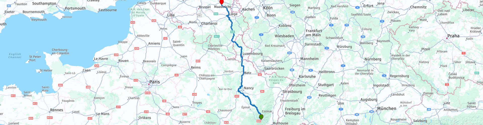
Col de Bussang to Hasselt while driving by the Moselle river and crossing the Ardennes

This route was brought to you by:
RouteXpert Guy Heyns - Sr RouteXpert
Last edit: 10-12-2024
 Route Summary
 Could it be faster, maybe. Could it be more beautiful? Maybe so, but not in one day if you also want to enjoy it a bit. And luckily that is also possible on this route!
This route combines the return to Belgium with a little "hydrocultural" knowledge.
After all, the route runs for a large part via the well-known Moselle and the Canal de l'Est back through Luxembourg to Flanders.
The road may be long, but it is beautiful and there is something to see if you are willing to pay attention to it.
That is why we almost wanted to give this route a five star rating, but at the last minute we withdrew our opinion. Finally, you also do a large part of 'boring', but insurmountable highway kilometers.
Nevertheless, this route is definitely recommended. She will take you where you need to be from the Vosges via fun, interesting roads and you will learn something too!
 Share this route


Animation

Verdict


Duration
9h 41m

Mode of travel
Car or motorcycle

Distance
511.24 km

Countries


 RouteXpert Review
 The ridge that remained formed the border between France and Germany from 1871 to 1918. 1918, you read that right. The end of the First World War. Afterwards, boundaries were literally shifted, but you can already imagine that the terrain of the Vosges during WW I was a particularly turbulent area…
This is the return route that takes you from Col de Bussang in the Vosges back to the Flemish Hasselt in Limburg.
Nevertheless, this route cannot be called traditional as you can also learn something from it. At least if you have an eye and attention for it.
We start in Hotel du Col de Bussang after we have said goodbye to our host and lady.
A first petrol station can be found 27 kilometers after the start of the route. However, remember that refueling in Luxembourg is much cheaper. Fill in appropriately. A small recommendation can also be to stop at an Intermarché or another department store along the way to stock up on a picnic. Really good bars & cafes are harder to find in the first part. Beautiful picnic areas, on the other hand…
Picnic stuff crammed into the suitcases you drive towards rp 15 where you will find a lovely picnic area. You will really have no trouble finding the right place for a short break. If the weather conditions are not ideal for an outdoor break, the boulangerie slightly further away may offer a pleasant and, above all, covered alternative.
But before you arrive at one of these points, you first pass the Moselle and shortly afterwards the Canal de l'Est. I would like to say a few words about that….
The Moselle originates in the Vosges. You may have driven one of the “Ultimate Collection” routes that took you to the source of this all-important river. You probably also remember how small this well actually was.
The Canal de 'l'Est has been an inseparable part of the Moselle since 1874 when they started building the canal.
The canal has a length of no less than 439 km and connects the Saône with the Meuse and the Moselle. It is therefore not surprising that the skippers gave the canal the names 'Canal de la Meuse' and 'Canal des Vosges' for the northern and southern parts of the canal respectively.
A large part of this route goes along the Moselle and the Canal de l'Est, but from rp 16 it gets really interesting.
The Canal de l'Est not only connects the Meuse with the Saône & Moselle, it also 'replaces' the Moselle on those parts that are less navigable or even not navigable at all. The canal must therefore remain close to the Moselle and so it does… The canal sometimes even crosses the Moselle, which really does require some thinking. After all, how do you let a canal, which is fed by the Moselle itself, flow completely over the river without the waters touching? It goes without saying that the 152 locks and pump systems play a very important role in this. But just think… we are talking about construction in 1874….
Near rp 16 near Flavigny-sur-Moselle you can visit such an aqueduct if you wish. Still a bit of a hallucinatory sight... Aqueducts were therefore not only built by the Romans...
From rp 16 it is best to keep the camera or the mounted GoPro at the ready. From now on you will experience a dignified example of hydroponics and that for about 130 km. You literally flirt along the Moselle, the Canal and the many other water features. Those with an eye for it will also see the prosperity and other consequences of the Moselle and associated waterworks.
At rp 19 you can, if desired, take a break where you can enjoy a more extensive lunch along the Terrouin. You are only 174 km away, but you have been in the saddle for almost 5 hours, so think about it.
'Le Terrouin' is an interesting gabber… David who takes on Goliath and wins the battle too. The small, 30-kilometre-long river was solely responsible for the fact that the Moselle, 300 000 years ago and originally flowing into the Meuse, had to shift its bed eastwards in the direction of the Rhine. Today the entire course of the Terrouin is a protected nature reserve. At 'Le Pavillon Blue', our lunch spot, you can see the Terrouin flowing into the Moselle after it has won the battle for the river bed with flying colours.
After lunch we flirt a little further with the river and canal and finally, after the first 200 kilometers, we start the first highway ride.
50 kilometers further and after passing/crossing the cities of Metz & Thionville you can respectfully say goodbye to the mighty Moselle. You pass it for the last time near Thionville.
You quickly reach the border crossing between France and Luxembourg. You can take a coffee stop on the Aire de Berchem. I would postpone refueling for a while and – just like in the approach route – I advise against leaving your motorcycles unattended.
You round Luxembourg city and Ettelbruck, after which the route spoils you with a non-motorway passage. After all, we drive inland via the Parc Naturel de la Haute-Sûre to Pommerloch where we can stock up on the last Luxembourg's valued petrol. If desired, a coffee stop can be arranged in the stylish Pommerloch Hotel just before the petrol stations. The choice is yours, but please note that this is the last stop before we start the last highway trek to the farewell point in Hasselt.
Fortunately, there you will also find the necessary sanitary and other facilities so that you can say goodbye to your travel colleagues – fully illuminated – in one of the restaurants or not.
Due to the many boring highway kilometers, the route cannot of course obtain a five-star rating, but to be honest, because of the aquacultural wealth it really doesn't make much difference. A passage through this area will teach you a lot if you want to pay attention to it. The roads are particularly well laid out and will sometimes pleasantly surprise you – also in terms of views and driving pleasure. Therefore an absolute well-deserved 4 stars for this instructive return route.


 Links
Links  Usage
Usage Want to download this route?
You can download the route for free without MyRoute-app account. To do so, open the route and click 'save as'. Want to edit this route?
No problem, start by opening the route. Follow the tutorial and create your personal MyRoute-app account. After registration, your trial starts automatically.  Disclaimer
Use of this GPS route is at your own expense and risk. The route has been carefully composed and checked by a MyRoute-app accredited RouteXpert for use on TomTom, Garmin and MyRoute-app Navigation.
Changes may nevertheless have occurred due to changed circumstances, road diversions or seasonal closures. We therefore recommend checking each route before use.
Preferably use the route track in your navigation system. More information about the use of MyRoute-app can be found on the website under 'Community' or 'Academy'.

Grand Est
About this region
Grand Est (French: [ɡʁɑ̃t‿ɛst] (listen); Alsatian: Grossa Oschta; Moselle Franconian/Luxembourgish: Grouss Osten;
Rhine Franconian: Groß Oschte; German: Großer Osten [ˈɡʁoːsɐ ˈʔɔstn̩]; English: "Greater East") is an administrative region in Northeastern France. It superseded three former administrative regions, Alsace, Champagne-Ardenne and Lorraine, on 1 January 2016 under the provisional name of Alsace-Champagne-Ardenne-Lorraine (pronounced [alzas ʃɑ̃paɲ aʁdɛn lɔʁɛn]; ACAL or, less commonly, ALCA), as a result of territorial reform which had been passed by the French Parliament in 2014.The region sits astride three water basins (Seine, Meuse and Rhine), spanning an area of 57,433 km2 (22,175 sq mi), the fifth largest in France; it includes two mountain ranges (Vosges and Ardennes). It shares borders with Belgium, Luxembourg, Germany and Switzerland. As of 2017, it had a population of 5,549,586 inhabitants. The prefecture and largest city, by far, is Strasbourg.
The East of France has a rich and diverse culture, being situated at a crossroads between the Latin and Germanic worlds. This history is reflected in the variety of languages spoken there (Alsatian, Champenois, and Lorraine Franconian). Most of today's Grand Est region was considered "Eastern" as early as the 8th century, when it constituted the southern part of the Francian territory of Austrasia. The city of Reims (in Champagne), where Frankish king Clovis I had been baptized in 496 AD, would later play a prominent ceremonial role in French monarchical history as the traditional site of the coronation of the kings of France. The Champagne fairs played a significant role in the economy of medieval Europe as well. Alsace and Lorraine thrived in the sphere of influence of the Holy Roman Empire for most of the Middle Ages and Renaissance, and subject to competing claims by France and German over the centuries.
The region has distinctive traditions such as the celebration of Saint Nicholas Day, Christmas markets, or traditions involving the Easter hare in Alsace and Lorraine. Alsace-Moselle are furthermore subject to local law for historical reasons. With a long industrial history and strong agriculture and tourism (arts, gastronomy, sightseeing), the East of France is one of the top economic producing regions in the country.
Read more on Wikipedia
Rhine Franconian: Groß Oschte; German: Großer Osten [ˈɡʁoːsɐ ˈʔɔstn̩]; English: "Greater East") is an administrative region in Northeastern France. It superseded three former administrative regions, Alsace, Champagne-Ardenne and Lorraine, on 1 January 2016 under the provisional name of Alsace-Champagne-Ardenne-Lorraine (pronounced [alzas ʃɑ̃paɲ aʁdɛn lɔʁɛn]; ACAL or, less commonly, ALCA), as a result of territorial reform which had been passed by the French Parliament in 2014.The region sits astride three water basins (Seine, Meuse and Rhine), spanning an area of 57,433 km2 (22,175 sq mi), the fifth largest in France; it includes two mountain ranges (Vosges and Ardennes). It shares borders with Belgium, Luxembourg, Germany and Switzerland. As of 2017, it had a population of 5,549,586 inhabitants. The prefecture and largest city, by far, is Strasbourg.
The East of France has a rich and diverse culture, being situated at a crossroads between the Latin and Germanic worlds. This history is reflected in the variety of languages spoken there (Alsatian, Champenois, and Lorraine Franconian). Most of today's Grand Est region was considered "Eastern" as early as the 8th century, when it constituted the southern part of the Francian territory of Austrasia. The city of Reims (in Champagne), where Frankish king Clovis I had been baptized in 496 AD, would later play a prominent ceremonial role in French monarchical history as the traditional site of the coronation of the kings of France. The Champagne fairs played a significant role in the economy of medieval Europe as well. Alsace and Lorraine thrived in the sphere of influence of the Holy Roman Empire for most of the Middle Ages and Renaissance, and subject to competing claims by France and German over the centuries.
The region has distinctive traditions such as the celebration of Saint Nicholas Day, Christmas markets, or traditions involving the Easter hare in Alsace and Lorraine. Alsace-Moselle are furthermore subject to local law for historical reasons. With a long industrial history and strong agriculture and tourism (arts, gastronomy, sightseeing), the East of France is one of the top economic producing regions in the country.
View region
 Statistics
  81
81Amount of RX reviews (Grand Est)
 35881
35881Amount of visitors (Grand Est)
 12536
12536Amount of downloads (Grand Est)
 Route Collections in this region
 25 Magnificent trails in France
This MRA route collection contains 25 beautiful motorcycle routes in different parts of France, such as the Ardennes, the Alsace, Vercors, the Drôme, the Ardèche, Cote d'Azure, Gorges du Verdon, the Ariège, the Dordogne and Brittany.
The routes have been carefully created by Bert Loorbach, who is an enthusiastic motorcyclist himself. He lived in France for a year and a half, during which time he devoted himself to mapping the unknown and beautiful back roads of France especially for motorcyclists.
The routes are bundled in the Motortourgids France part 1 of Kosmos publishing house and now also available in MyRouteApp.
I have taken over the routes in MRA and sometimes adjusted them slightly to make them even more interesting for the motorcyclist.
View Route Collection
11 day trip from the Netherlands
8 countries in 11 days; The Netherlands, Germany, Austria, Italy, Switzerland, France, Luxembourg and Belgium. This route collections consists of 10 routes that I have driven with friends in the summer of 2019.
The start is in Geldermalsen Netherlands, the first 7 days you drive through the Netherlands, Germany, Austria, Italy, Switzerland, France and a piece of Luxembourg with overnight stays in hotels.
The last three days you stay in Barweiler (D) in the Eifel and you drive two beautiful tours through the Eifel, Luxembourg and parts of the Belgian Ardennes.
There is no highway in the routes, only beautiful provincial and country roads, many beautiful passes with beautiful panoramas.
Be sure to check whether the passes are open before you leave.
These are routes for experienced drivers.
View Route Collection