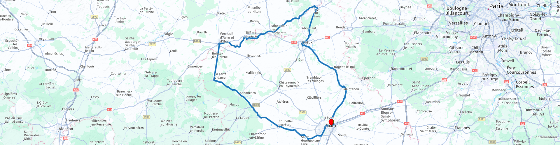
Roundtrip from Chartres to Chartres along the river Eure

This route was brought to you by:
RouteXpert Catherine De Groote RouteXpert
Last edit: 26-05-2022
 Route Summary
 The rich history of this department is reflected in the large number of impressive castles in this region.
Today, the department of Eure-et-Loir is a pleasant holiday destination. It offers a nice combination of historical places such as Chartres and Dreux on the one hand and beautiful nature on the other. There is also no shortage of impressive sights in this region; from the beautiful castle of Maintenon to the beautiful cathedral of Chartres. There is always something to see or experience in this department!
This tour through Eure-et-Loir takes you through a piece of Île-de-France as well as through Normandy. As you drive from castle to castle, the landscape around you is constantly changing. You drive through forests, past lakes and vast wheat fields. The highlight is undoubtedly the magnificent cathedral of Chartres and the royal chapel of Dreux. The roads chosen are generally quiet and of good quality. A route worthy of five stars.
 Share this route


Animation

Verdict


Duration
10h 49m

Mode of travel
Car or motorcycle

Distance
193.02 km

Countries

 RouteXpert Review
 From Saint-Prest you follow the banks of the Eure. The Eure is 225 km long and rises in Marchainville (Orne department) and joins the Seine in Pont-de-l'Arche (near Rouen).
In St-Piat you leave the D6 to pass the Aqueduc de Maintenon not much further. The aqueduct is an unfinished building, located on the domain of the castle of Maintenon in the valley of the Eure. It was an essential part of the Canal de l'Eure with the purpose of supplying the Palace of Versailles with water. King Louis XIV ordered this. The aqueduct would be a maximum of 70 meters high, measured from the valley floor. The plans were based on three arcs above each other to achieve this. Construction started in 1686, two years earlier they had already started digging the canal. In 1688 the work stopped because of the war and the high costs. Only the lower row of arches was completed, and the work remained unfinished. The aqueduct is classified as a historic monument.
Maintenon Castle is an elegant Renaissance building. Louis XIV gave this castle to a young widow, 25-year-old Madame de Maintenon, who became the governess of his children, then his (unofficial) mistress and finally his (secret) wife.
Over the centuries, the Château de Maintenon has undergone many transformations. The defensive character of the primitive fortified castle was definitively erased in favor of the comfortable and modern noble residence. The main changes were made in the 16th and 17th centuries. In the 19th century, the facades of the main courtyard were modified. During the Second World War, the estate was heavily damaged. It was extensively restored in the following years and is now open to the public.
You now follow the course of the Eure to Nogent-le-Roi. This place owes its name to the fact that the kings Philip II and Louis IX successively owned a castle here. The town has preserved many testimonies of its past, such as the typical wooden-walled houses that cluster around the charming church. Located on the banks of the river Roulebois, the Saint-Sulpice church from the 15th and 16th centuries boasts beautiful stained glass windows. The church was built on an old 11th century sanctuary, of which there are no remains, and was connected to the fortified castle. However, the monument was never finished. The nave on the main street was never built, hence the facade on which the ornaments are missing. Through a simple door you enter directly into the choir and the ambulatory, giving the whole a strange feeling of imbalance. The interior is richly decorated with stained glass windows, as well as wooden cenotaphs and altarpieces and an 18th-century choir trellis.
Attention: when leaving the center TomTom gives an error. You have to keep following the main road on the left.
The Eure flows through and past a whole series of villages, before widening into a lake at Mézières-Ecluzelles. Here is a large water sports center.
Then continue to Dreux. The name of this ancient city is derived from the Durocasses, a Gallic tribe. In Dreux you can view the Chapalle Royale, high on the hill. It is a beautiful monument, in the middle of a green park. Built in 1816 on the site of the former fortress, the chapel houses the counts of the Bourbon-Orléans family. The first neoclassical building built by the Duchess of Orléans, it was later enlarged in the neo-Gothic style. From 1830, the chapel became the necropolis of the Maison de France with ubiquitous sculptures, reclining marble figures, allegorical bas-reliefs and a fully sculpted vault. The Manufacture Royale de Sèvres supplied here beautiful painted and enamelled stained glass windows inspired by religious or historical compositions such as 'the life of Saint-Louis', patron saint of the royal chapel.
In the crypt of this neo-Gothic chapel from the 19th century, you will find the tombs of Louis Philip I, the last French king, and the last royal descendants of the House of Orléans.
You leave the city and you follow the D928, which runs like a sunken road between walls of green through the beautiful Fôret de Dreux. You will encounter few bends here, which invites you to accelerate, but make sure you do not exceed the speed limit of 80 km/h and watch out for crossing animals!
You arrive in Anet, where there is a castle from 1547. It was commissioned by Diana of Poitiers, also a widow, royal lover and regent, but this time at the court of King Henry II. The castle is privately owned and only accessible if you request a guided tour. The adjacent burial chapel of Diana is open to the public. Her remains, removed during the French Revolution, have been replaced in the original black and white marble tomb.
Cross the Eure just before entering Ézy-sur-Eure. In restaurant Le Black Bird, an English pub, you can enjoy an abundant lunch buffet.
You then head towards Marcilly where you leave the river valley to head west to the hamlet of Le Brémein. Watch out for the last stretch, because before La Madeleine-de-Nonancourt there is a surprising hairpin bend after a long stretch of straight road.
In Tillières you follow the course of another river, the Avre, which forms the traditional border with Normandy. You can drive quietly through a beautiful green valley to Verneuil-sur-Avre, a medieval fortified town that guarded the old route to Normandy. The environment here is already reminiscent of the Normandy bocage landscape.
Verneuil is really worth a detour. The city was built in 1150 by one of William the Conqueror's sons and has a lot of character: old city walls, reinforced by a moat, a keep, beautiful medieval houses and the large Place de la Madeleine, where the church stands out from a disproportionate bell tower in flamboyant gothic style. The 56 m high tower, visible for miles around, has become the symbol of the city. The church is dedicated to Saint Mary Magdalene. Construction started at the beginning of the 12th century, simultaneously with the foundation and development of the city. The tower was built at the end of the 15th century, but lack of resources interrupted construction for 30 years. It was thanks to the generosity of the Bishop of Senlis, Artus Fillon, a native of Verneuil, that the building was completed around 1525.
In Brasserie de la Place or in Pub de la Madeleine, with a view of the cathedral, you can enjoy a refreshing drink or a delicious coffee on the terrace.
Exit Verneuil-sur-Avre in a southerly direction. You are now entering a completely different landscape. The road continues straight for 15 km between fields, without a single bend, to end in La Ferté-Vidame.
There you immediately see the access road to an imposing castle ruin. Built on the remains of a medieval fortress, the castle was the fief of the courtier Louis de Rouvroy, Duke of Saint-Simon and author of the famous work 'Mémoires', about everyday life at the court of Louis XIV. The castle was extensively renovated in the 18th century (it is said to have had 167 rooms afterwards), but was destroyed during the French Revolution. What remains is the colossal facade and the park of over 900 hectares (free entrance).
If you drive to Senonches, you will see the landscape change again. You now enter one of the most beautiful forests of the Perche and the road winds along enticing lakes (Étang d'Haron, Étang de la Banette, Étang de Tardais).
After Senonches, take the road that continues through the forest towards Pontgouin and follow the signs to the Écluses de Boizard. After another bit through the forest, you come to an old reservoir and an abandoned dam from the time of Louis XIV. The Sun King had wanted to channel the river to supply water to Versailles, 100 km away.
A little further you can visit the enormous domain of the Château de la Rivière. It is an elegant ensemble from the early 17th century that has been little changed over four centuries. The main body of the castle was completed in 1628, the outbuildings in 1629. The architecture is simple and harmonious, using local Grison materials. The castle is built lengthwise, most of the rooms being crossed by light. The outbuildings are U-shaped and close off the courtyard in front of the castle. The whole is surrounded by a network of canals and moats that flow into the Eure that runs between the castle and the star-shaped park. A school for young girls was located here during the Second World War. Between 1954 and 2009 it was owned by a well-known family in film production and distribution. Many film personalities frequented there, such as Michel Audiard, Jean Gabin and Lino Ventura.
Via Pontgouin and Courville you return to Chartres, which is built on a rocky plateau. The city center is traffic-free. You park the motorcycle in one of the car parks that are within walking distance of the center.
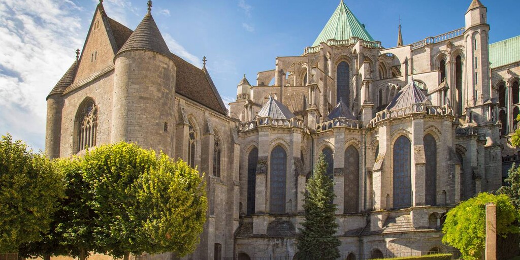
Notre-Dame de Chartres Cathedral is a monument of Gothic architecture and is traditionally considered one of the best-preserved cathedrals of this style for its sculptures, stained glass windows and tiling. It was built at the beginning of the 13th century, for 30 years, on the ruins of an earlier Romanesque cathedral, which was itself destroyed in a fire in 1194. With a relic of the Virgin Mary's veil, it is a major Marian pilgrimage site. The cathedral dominates the city of Chartres and the Beauce Plain and can be seen from over 10 kilometers away. The building is classified as a historical monument on the list of 1862. In addition, it is one of the first monuments to be included in the UNESCO World Heritage List in 1979.
From the gardens of the former bishop's palace you have a beautiful view of the Eure, which flows through the city to the north.
You can enjoy the afterglow of this ride in Restaurant Le Pichet 3. It is located near the cathedral. The restaurant includes three houses from different periods: one from the 1900 World's Fair in Paris, another from the Middle Ages and a more recent one.
Just outside Chartres in the parking lot of the La Madeleine shopping center is the end point of this beautiful route.

 Links
Links  Usage
Usage Want to download this route?
You can download the route for free without MyRoute-app account. To do so, open the route and click 'save as'. Want to edit this route?
No problem, start by opening the route. Follow the tutorial and create your personal MyRoute-app account. After registration, your trial starts automatically.  Disclaimer
Use of this GPS route is at your own expense and risk. The route has been carefully composed and checked by a MyRoute-app accredited RouteXpert for use on TomTom, Garmin and MyRoute-app Navigation.
Changes may nevertheless have occurred due to changed circumstances, road diversions or seasonal closures. We therefore recommend checking each route before use.
Preferably use the route track in your navigation system. More information about the use of MyRoute-app can be found on the website under 'Community' or 'Academy'.

Normandy
About this region
Normandy (/ˈnɔːrməndi/; French: Normandie [nɔʁmɑ̃di] (About this soundlisten); Norman: Normaundie; from Old French Normanz, plural of Normant, originally from the word for "northman" in several Scandinavian languages)[2] is a geographical and cultural region in Northwestern Europe, roughly coextensive with the historical Duchy of Normandy.
Normandy comprises mainland Normandy (a part of France) and the Channel Islands (mostly the British Crown Dependencies). It covers 30,627 square kilometres (11,825 sq mi).[3] Its population is 3,499,280. The inhabitants of Normandy are known as Normans,[1] and the region is the historic homeland of the Norman language. Large settlements include Rouen, Le Havre and Cherbourg.
The cultural region of Normandy is roughly similar to the historical Duchy of Normandy, which includes small areas now part of the departments of Mayenne and Sarthe. The Channel Islands (French: Îles Anglo-Normandes) are also historically part of Normandy; they cover 194 square kilometres (75 sq mi)[4] and comprise two bailiwicks: Guernsey and Jersey, which are British Crown Dependencies.
Normandy's name comes from the settlement of the territory by Vikings ("Northmen") starting in the 9th century, and confirmed by treaty in the 10th century between King Charles III of France and the Viking jarl Rollo. For four hundred years following the Norman conquest of England in 1066, Normandy and England were linked by having the same person reign as both Duke of Normandy and King of England.
Read more on Wikipedia
Normandy comprises mainland Normandy (a part of France) and the Channel Islands (mostly the British Crown Dependencies). It covers 30,627 square kilometres (11,825 sq mi).[3] Its population is 3,499,280. The inhabitants of Normandy are known as Normans,[1] and the region is the historic homeland of the Norman language. Large settlements include Rouen, Le Havre and Cherbourg.
The cultural region of Normandy is roughly similar to the historical Duchy of Normandy, which includes small areas now part of the departments of Mayenne and Sarthe. The Channel Islands (French: Îles Anglo-Normandes) are also historically part of Normandy; they cover 194 square kilometres (75 sq mi)[4] and comprise two bailiwicks: Guernsey and Jersey, which are British Crown Dependencies.
Normandy's name comes from the settlement of the territory by Vikings ("Northmen") starting in the 9th century, and confirmed by treaty in the 10th century between King Charles III of France and the Viking jarl Rollo. For four hundred years following the Norman conquest of England in 1066, Normandy and England were linked by having the same person reign as both Duke of Normandy and King of England.
View region
 Statistics
  15
15Amount of RX reviews (Normandy)
 19682
19682Amount of visitors (Normandy)
 1621
1621Amount of downloads (Normandy)
 Route Collections in this region
 3 day mini break through Brittany and Normandy
The overnight ferry crossing from Plymouth to Roscoff is a relaxing way to begin your 3 days of sightseeing in North West France. Touring the coasts and countryside of Brittany and Normandy, you'll discover beautiful sandy beaches, tiny fishing ports, bustling market towns and iconic and historical sites. Don't forget to sample Brittany's renowned seafood and delicious sweet and savoury pancakes, or Normandy cider and of course their 'hard to say no to' apple brandy, Calvados .
Day 1 takes you along the beautiful and rugged coast to Mont St Michel, a World Heritage site, visible for miles around. This is a wonderful place at any time of year, although be prepared for it to be very busy in summer. Your first hotel is just 30 minutes further along the coast at Hôtel Ibis Avranches Baie du Mont Saint-Michel. Other hotels are nearby and links for this hotel and your second night at Port en Bessin are in the individual route reviews.
Day 2 takes you first to Bayeux, world famous for its astonishing tapestry depicting the Norman Conquest of England in 1066, remarkable as a work of art and important as a source for 11th-century history. Bayeux also has a picturesque old quarter, WW2 museum and cathedral worth visiting (park motorcycles next to cathedral).
Then you can take in the sobering atmosphere at Pegasus Bridge, liberated by the British 6th Airborne Division glider unit, a full size replica of a Horsa glider shown in the picture above is on display, and the tale of the men it transported gives you a remarkable insight into the scale, ferocity and poignancy of Operation Overlord. Arromanches' Mulberry Harbour (Port Winston) and the gun emplacements dotted along the coast that you'll visit are reminders of the combats that took place here over 70 years ago. A great night is guaranteed at your second hotel in the fishing port of Port en Bessin where you can sample local cider (cidre) some of the freshest seafood available, fine wine, and finish off with some local calvados.
Day 3 tells the American story of D-Day with visits to Omaha and Utah beaches, various museums and the first town in France to be liberated during operation Overlord - Sainte-Mère-Eglise where an effigy of private John Steele dangles by his parachute from the church steeple.
Your return to the UK is via Cherbourg, to either Poole or Plymouth depending on the time of year, most sailings are around 17:00 hrs. Details from Brittany Ferries can be found in the link in the first review.
This is a great mini tour that'll give you a good glimpse of what this part of northern France has to offer and will leave you wanting to return.
View Route Collection
The 10 most downloaded routes in France from RouteXpert Catherine De Groote
Hello and welcome to this collection of the Top 10 MyRoute app downloaded routes in France.
A great new event will be announced soon, where all of these routes can be driven.
Download them all now and place them in a new "Top 10" folder so that you always have them at hand.
If you are going to drive one of these routes in the meantime, track them with the MRA Mobile App or with MRA Navigation. Take some photos (moments) along the way as they will come in handy.
Create a travelogue of your Top 10 driven routes and add the recorded track to it.
There will also be some great prizes on offer, so keep an eye on the MRA-RouteXperts page and your email.
View Route Collection