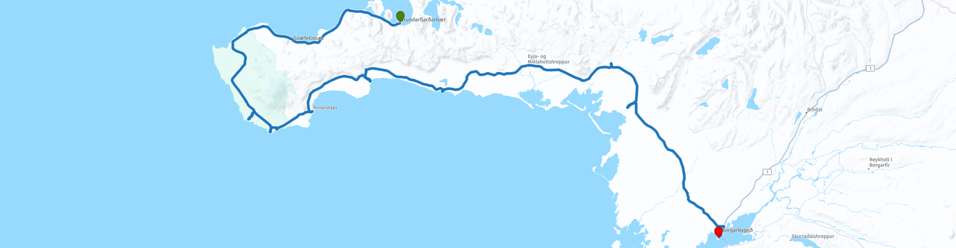
Day 11 of 12 Day Roadtrip Iceland Grundarfjordur Borgarnes

This route was brought to you by:
RouteXpert René Plücken (MRA Master)
Last edit: 24-10-2025
 Route Summary
 Driving in Iceland is a great experience, whether you travel by car or, as described in this review, by motorcycle.
These itineraries are based on information about Iceland found online, particularly from the Guide to Iceland, where you'll find a wealth of information to help you prepare for your trip. The material on this site has been compiled with great care; the link can be found in the review of the first itinerary in this series.
You will drive through landscapes that are varied and beautiful, you will see glacier tongues, volcanic mountains, geothermal areas with active geysers, lava fields, craters, forests, waterfalls and incredibly rugged stretches of coastline.
The routes in the north are part of the Arctic Coast Way.
The main roads are of good quality, but you'll also be traveling on gravel roads, making them unsuitable for road motorcycles. Some of these roads are sometimes closed due to weather. It's therefore important to check the weather forecast and road conditions every day before you leave. This information can be found on the website of the Icelandic Meteorological Office and, for road conditions, on the website of the Icelandic Road and Coastal Administration. Links are included in the review.
Due to the Icelandic climate, this trip can only be done in summer.
Route rating: ★★★★★
In one day, you'll see everything that makes Iceland so special: volcanoes, cliffs, caves, seals, waterfalls, lava fields, and unique coastal landscapes. A perfect ending to your Snæfellsnes trip.
 Share this route


Animation

Verdict


Duration
8h 38m

Mode of travel
Car or motorcycle

Distance
206.44 km

Countries

 RouteXpert Review
 Today we'll drive a short route of approximately 210 kilometers to enjoy the wonders of the Snæfellsnes Peninsula. We'll take our time stopping regularly at unique locations and taking photos as we follow the road around the headland.
Before leaving Grundarfjörður, you can join a whale-watching tour, offering Iceland's best chance of spotting orcas. Laki Tours, located in the harbor within walking distance of the hotel, offers these excursions. Definitely worth it!
After leaving, you'll soon arrive at the iconic Kirkjufell mountain and the nearby waterfall. Kirkjufell was one of the filming locations for Game of Thrones seasons 6 and 7. If you haven't visited it on day 10, now's the time. These spots are perfect for stunning photos.
The rest of the day is dedicated to exploring the incredible nature of Snæfellsnes. You'll have plenty of time to admire Snæfellsjökull National Park, the Lóndrangar cliffs, Rauðfeldsgjá canyon, Ytri Tunga beach, and the Eldborg Caldera, among other sights.
Highlights of the route:
• Snæfellsjökull National Park
Situated between Faxaflói Bay and the Breiðafjörður fjord, the Snæfellsjökull volcano (1,446 m) is covered by an ice cap and visible from Reykjavík in clear weather. The park offers numerous attractions and hiking opportunities.
• Djúpalónssandur
A historic sandy beach and bay, once a fishing village with sixty boats. You can still find the remains of the fishing boat Grimsby Epine (GY7), destroyed in 1948.
• Vatnshellir Lava Cave
During an impressive tour, you'll descend 200 meters into an 8,000-year-old lava cave. You'll discover colorful lava formations on two levels, up to 35 meters deep.
• Gestastofa Visitor Center
An accessible visitor center about the ecology and history of Snæfellsjökull. Free admission and suitable for all ages.
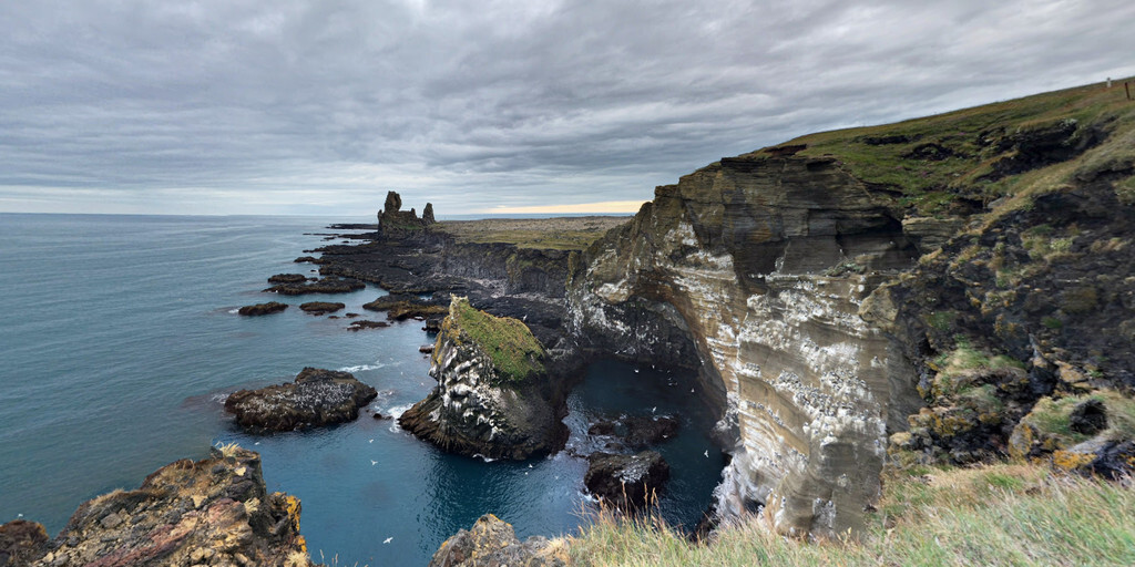
• Lóndrangar Cliffs
Uniquely shaped basalt formations, remnants of an ancient crater, protrude from the sea.
• Arnarstapi
A picturesque village with viewpoints, a natural stone bridge, and cozy cafes. Ideal for a short break.
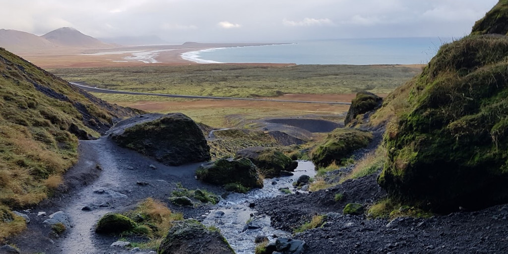
• Rauðfeldsgjá gorge
A narrow gorge in Botnsfjall Mountain. In summer, you can climb into it to a small waterfall. Make sure you wear sturdy, waterproof shoes.
• Búðir
Here you'll find the famous Búðakirkja Black Church, a golden beach, and basalt cliffs. There are also lava fields and a crater.
• Bjarnarfoss waterfall
An 80-foot waterfall, visible from Highway 54, that drops in two steps.
• Ytri Tunga Beach
A golden sand beach, known as the most reliable place in Iceland to spot seals – especially in summer.
• Gerðuberg Cliffs
An impressive row of basalt columns, 12–14 meters high. You can walk along the cliff for spectacular views.
• Eldborg Caldera
A beautifully formed crater, 60 meters high and 200 meters in diameter. The hike from Snorrastadir is 2.5 km through lava fields. You can walk around and on top of the crater.
After all this beauty we drive to the end point in Borgarbyggð, where we spend the night.
 Links
Links  Usage
Usage Want to download this route?
You can download the route for free without MyRoute-app account. To do so, open the route and click 'save as'. Want to edit this route?
No problem, start by opening the route. Follow the tutorial and create your personal MyRoute-app account. After registration, your trial starts automatically.  Disclaimer
Use of this GPS route is at your own expense and risk. The route has been carefully composed and checked by a MyRoute-app accredited RouteXpert for use on TomTom, Garmin and MyRoute-app Navigation.
Changes may nevertheless have occurred due to changed circumstances, road diversions or seasonal closures. We therefore recommend checking each route before use.
Preferably use the route track in your navigation system. More information about the use of MyRoute-app can be found on the website under 'Community' or 'Academy'.