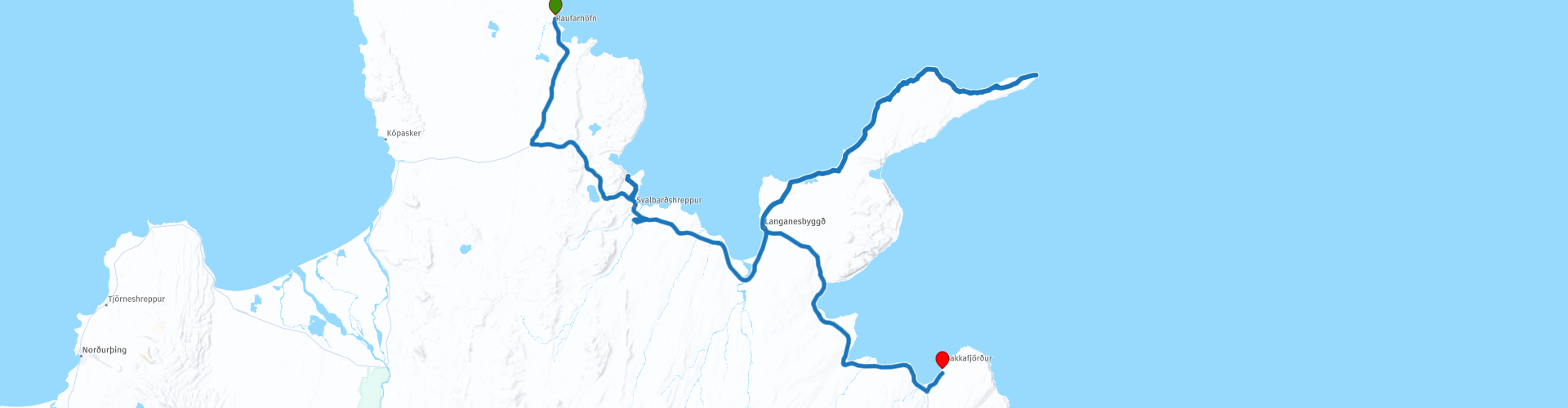
Arctic Coast Way Day 6 Raufarhofn Bakkafjordur

This route was brought to you by:
RouteXpert René Plücken (MRA Master)
Last edit: 16-03-2021
 Route Summary
 The Arctic Coast Way starts in Hvammstangi in the North West and ends in Bakkafjörður in the North East. This approximately 900 kilometer long “Off the Beaten track” route passes through rugged North Iceland and follows the beautiful Fjord coast.
Driving the Arctic Coast Way is different from what you might be used to. It is a true off the beaten track route that takes you through beautiful remote landscapes. This means leaving civilization behind in the spirit of adventure and exploration.
We drive large parts on unpaved roads (about 1/3 part), sometimes with large holes, so this route is only suitable for Adventure or Off Road motorcycles or for cars with 4x4 drive. Drive slowly to enjoy the magical surroundings but because of the sheep and birds that can walk on the road.
The route runs close to the Arctic Circle and many stops are planned along the way to visit Iceland's many highlights. A number of examples are the many waterfalls, glaciers, fishing villages and fjords. In some cases you have to take a walk (hike), these can influence the planning of the rides, so keep that in mind. Due to the slower speed on the unpaved roads and the sights en route, the routes have been kept short.
Enjoy the freedom along the way, but respect nature and keep in mind that wild camping is prohibited, you are only allowed to camp on campsites or with the permission of the owner on his private property. All villages along the route have camping options. All campsites have rubbish bins and sanitary facilities. Do not drive off-road, but stay on the designated roads. Off-road driving is prohibited, with heavy fines.
This is the sixth and last day of the six-day Arctic Coast Way Roadtrip that I rate with 5 ***** Stars for its beautiful nature, beautiful places to visit and the adventurous aspect.
Enjoy!
 Share this route


Animation

Verdict


Duration
15h 4m

Mode of travel
Car or motorcycle

Distance
226.05 km

Countries

 RouteXpert Review
 Along the way there are a number of stops planned to take pictures of the beautiful Icelandic nature, we will also have to walk for a number of points (hiking) but they are definitely worth it.
The route is short but, including the walks, it certainly takes the whole day. The first hike is at the cape of Rauðanes (RP4), which is located in the Þistilfjörður fjord. It is dotted with beautiful and strange rock formations and Sea Stacks, hidden beaches and large caves. The walk on Rauðanes Cape is 7 km long, an easy 2.5 hour hike. The path is marked with numbers 1-16. At the parking lot is a map showing the names of the places indicated on the route. If you do not have a map of the Rauðanes Cape, it is best to take a picture of the map and refer to it during the walk.
After the Hike we drive to the Leader Sheep Center (RP6). This sheep center of Leader Sheeps in Þistilfjörður is unique in the world, because Iceland is the only country in the world where Leader Sheep exist.
You will find collections of photos, stories and information about the Leader Sheep. There is a small shop with handcrafted products made from Leader Sheep's wool, horns, bones and hides. In a small café you can enjoy a special blend of coffee and delicious pastries. Open from 11am to 6pm, July-August and by appointment in the other months.
We drive to Þórshöfn (RP8), a small fishing village on the fjord where we have lunch at the Báran Restaurant, they have the perfect setting to enjoy a delicious meal.
The dining room overlooks the harbor and fishing boats. Báran specializes in preparing fresh local dishes using meat and vegetables from the surrounding farms and local fish from local boats. Recommended!
After lunch, drive to Fontur or “Langanesfontur” (RP9) is the northernmost land point of the Icelandic peninsula Langanes. This cape consists of cliffs of 50 to 70 meters high that rise from the Norwegian Sea. Fontur is accessible via an unpaved road that is only accessible to four-wheel drive vehicles.
A lighthouse was built at Fontur in 1910, which was renovated in 1914 and 1950. Sometimes concerts are organized in this lighthouse. Since 1994 there has also been an automatic weather station at Fontur.
The next stop is also our final destination in Bakkafjörður, ending a beautiful 900-kilometer drive on the Arctic Coast Way. You can spend the night at camping Bakkafjörður.


 Links
Links  Usage
Usage Want to download this route?
You can download the route for free without MyRoute-app account. To do so, open the route and click 'save as'. Want to edit this route?
No problem, start by opening the route. Follow the tutorial and create your personal MyRoute-app account. After registration, your trial starts automatically.  Disclaimer
Use of this GPS route is at your own expense and risk. The route has been carefully composed and checked by a MyRoute-app accredited RouteXpert for use on TomTom, Garmin and MyRoute-app Navigation.
Changes may nevertheless have occurred due to changed circumstances, road diversions or seasonal closures. We therefore recommend checking each route before use.
Preferably use the route track in your navigation system. More information about the use of MyRoute-app can be found on the website under 'Community' or 'Academy'.