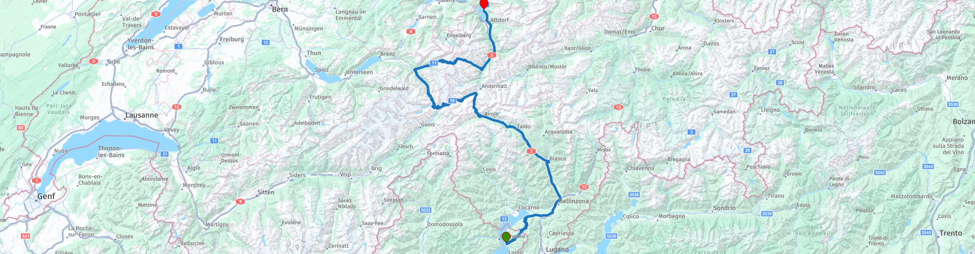
R03 - Maccagno to Sisikon

This route was brought to you by:
RouteXpert Arno van Lochem - Senior RX
Last edit: 30-07-2023
 Route Summary
 The start of this route is at Albergo Paradiso on Lake Maggiore. Via a number of well-known passes such as the St. Gotthard Pass, the Furka Pass and the Grimsel Pass, the route ends at the Tellsplatte hotel. This hotel enjoys a truly breathtaking location on Lake Vierwaldstättersee. Sit on the terrace with a wonderfully cooling Weizen and enjoy the view. Then you almost think "I'm never leaving here!"
The route is for the more advanced motorcyclist given the occasional tight hairpin bends in the Alps. Good engine control is desirable!
This route is part of the collection 'From Innsbruck to Holland in 7 days', see section 'Links' under the photos.
 Share this route


Animation

Verdict


Duration
5h 59m

Mode of travel
Car or motorcycle

Distance
271.59 km

Countries


 RouteXpert Review
 The route starts at Albergo Paradiso on the beautiful Lago Maggiore. You don't get the chance to warm up the bike first, after 350 meters you turn into a narrow, steep street in the center and the climbing is blown. In a short time you climb to a height from which you have a beautiful view over Lake Maggiore.
A little further on, you drive over today's first pass, the Passo dell'Alpe di Neggia, lying at an altitude of 1,395 meters. Not a particularly high pass, but still a beautiful view of the surrounding peaks on top. Definitely worth a moment for a photo.
At the bottom of the descent you drive again along the waterline of Lake Maggiore. At Bellinzona, TomTom does not understand that you can just go straight ahead and turns right into a small road. Don't turn off, just drive straight ahead. Garmin does give the correct indication.
A few kilometers further you reach Biasca. Since you have already covered almost 75 kilometers, it is time for coffee. This is possible at hotel Svizzero, a small but good hotel where they serve delicious coffee.
After coffee, you set course for the beautiful Gotthard Pass. Look out for a while at the second roundabout after Biasca. TomTom clearly indicates the right way ('180 degrees' straight ahead), while Garmin wants you to turn at almost three-quarters of the roundabout. Now that is going to be difficult, because there is a fence. But beyond that lies the old road. If you take the right exit you can immediately turn left onto the old road, but since it is a dead end, you better not do that. Follow the signs 'San Gottardo' then it can hardly go wrong. After just less than 1 kilometer you will see that you are back on the route.
Before you reach the Gotthard Pass you first have the opportunity to visit the waterfall in the river Piumogna. This waterfall has a fall height of 43 meters and is considered one of the most spectacular in this area. It is easily accessible on foot, there are parking lots nearby and it is an unmissable attraction for nature lovers. A suspension bridge over the creek, which gives the name to this wild waterfall, allows visitors to enjoy a natural spectacle of rare beauty in complete safety.
Once you are back on the road you still have about 20 kilometers to go before reaching the Gotthard Pass. Make no mistake, those are 20 beautiful kilometers. Beautiful mountains, nice mountain villages and vast green meadows determine the scenery through which you drive.
At some point you will reach the point where the Gotthard tunnel (17km!) Starts. The routes that run along the top also start there. There is an old and a new part, this climb runs entirely over the old part. Only in the descent do the routes come together at a certain point.
A warning is in order, the pavement of this pass still consists in part of so-called cobblestones, especially in bends. When the road surface is wet, these can be treacherously slippery. With a dry road there is little to worry about, except for the bumping ...
Also pay attention to the higher situated new part of the pass when climbing. The panorama galleries are beautifully visible from the old pass. Only then does it become apparent what a gigantic building this is and what an effort it must have cost.
After the Gotthard you arrive at Hospental, turn left and start the ascent of the Furka Pass. You follow the 19 to Realp. That's where the last part of the climb starts. On top of the pass you have a beautiful view (if the weather cooperates), reason to stop for a few photos.
In the descent you will soon arrive (3rd hairpin bend) at hotel Belvedere. This old hotel is widely known from photos. If you say Furka Pass, you say Hotel Belvedere. Wonderful to stop in the parking lot and take a few pictures.
Another reason to stop here is because if you stand with your back to the hotel in the parking lot, you will see the path that takes you to the Rhône glacier. It's a short walk of approx. 200 meters.
Since the opening of today's Furka pass 150 years ago, thousands of tourists have come to see this unique mountain panorama with the Rhone glacier. Nowadays you park at the Hotel Belvédère and you walk to the ice cave drilled every year. The glacier itself looks white-gray, but in the 100-meter long ice tunnel and in the ice hall, everything lights up in magical subtle shades of blue. The glacier here moves 30 ~ 40 meters per year, sometimes more than 10 cm in a day. Also a lot of ice melts away during the summer; the ice cave is still 100 meters deep at the start of the season, and only 70 meters at the end of the summer. One can enjoy this glacier panorama from the viewing platform and soon also from the platform at the glacial lake. This is because a new glacial lake is created at the foot of the glacier. Take a moment to contemplate this beautiful natural phenomenon!
At the bottom of the pass you come to the mountain village of Gletsch, a hamlet consisting of a large old luxury hotel (royal) with a mountain station and an Anglican chapel. It is part of the village of Oberwald. After being closed for years it has been put back into use as it is considered a monument. Gletsch is deserted in the winter.
After lunch you immediately start climbing the Grimsel Pass. After a number of hairpin bends you arrive at a small lake, the Totesee, located at the top of the Grimselpass. A little further on is the Grimselsee, which is a lot bigger.
To be able to view and photograph the area well, you can turn left just after the water and park at the indicated spot.
A little further there is the possibility to walk over a suspension bridge, the Handeckfallbrücke. The suspension bridge got its name on the one hand because of the place name Handeck and on the other because it crosses several waterfalls. Even though the suspension bridge itself is right next to the valley station of the Gelmerbahn and is also used to cross the motorway below, it is very pleasantly surrounded by beautiful nature and equally well integrated into it. The fact that it is a magnet for suspension bridge fetishists has certainly also been included in the planning of the project.
Some details of the suspension bridge: Wingspan: 70 meters, height: 70 meters and width: 65 centimeters. Bring it on if you dare! And it's free too ...
You continue the route towards Innertkirchen, where the route turns right towards the Sustenpass. This forms the connection between Innertkirchen and Wassen. The pass is located at an altitude of 2,224 meters. The current road was built between 1938 and 1945, making it one of the newer Swiss pass roads. The Susten Pass is rarely used as a transit route and is especially important for tourism. For this reason, the road is not kept free of snow during the winter.
From Innertkirchen the road leads up through the sparsely inhabited Gadmental. The highest point of the route over the Susten Pass is in a short tunnel. There are a few buildings and spacious parking spaces on the Bernese side. The actual Susten Pass can only be reached on foot. The descent takes you through the green Meiental to Wassen. During this descent there is the possibility to stop at Sustenbrüggli for a cup of coffee or something else. This gives you the opportunity to enjoy the Meiental during this break.
From Wassen the route runs over the 2, which meanders along the A2. At Fluelen you can already see the water of the Vierwaltstättersee. A few kilometers further on you turn left for the last time (just before the tunnel!) To arrive at today's end point. That is hotel Tellsplatte in Sisikon. A hotel in a beautiful location with an even better view. Enjoy with a capital G.
Have fun driving this route!


 Links
Links  Usage
Usage Want to download this route?
You can download the route for free without MyRoute-app account. To do so, open the route and click 'save as'. Want to edit this route?
No problem, start by opening the route. Follow the tutorial and create your personal MyRoute-app account. After registration, your trial starts automatically.  Disclaimer
Use of this GPS route is at your own expense and risk. The route has been carefully composed and checked by a MyRoute-app accredited RouteXpert for use on TomTom, Garmin and MyRoute-app Navigation.
Changes may nevertheless have occurred due to changed circumstances, road diversions or seasonal closures. We therefore recommend checking each route before use.
Preferably use the route track in your navigation system. More information about the use of MyRoute-app can be found on the website under 'Community' or 'Academy'.