Veendam Drentsche Aa

This route was brought to you by:
RouteXpert Gerard Martens Route Expert
Last edit: 11-02-2019
 Route Summary
 You pass through old villages and along heathlands, and drive through the woods.
In Zeegse you can have lunch at Het Witte Huis or Het Texas Ribhouse. The second stop is at the Infocentrum of the Boomkroonpad.
 Share this route


Animation

Verdict


Duration
3h 4m

Mode of travel
Car or motorcycle

Distance
119.50 km

Countries

 RouteXpert Review
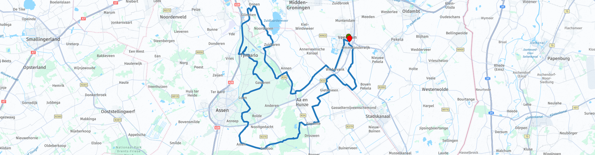
 Via Eexterzandvoort we dive into the National Park Drentsche Aa at Eext. The Nationaal beek- en esdorpenlandschap Drentsche Aa is a national park in the Dutch province of Drenthe. It was established on 4 December 2002 and covers over 100 km² with 16 villages and hamlets. At Zuidlaren known from the Zuidlaardermarkt we go towards Onnen. At Onnen we drive over the Railway yard of the NS via an iron viaduct, this is a beautiful photo opportunity. Then we drive back to the National Park Drentsche Aa and hold a short break in Zeegse. After old villages such as Oude Molen and Gasteren we pass through the Balloërveld. The Balloërveld is a hamlet and a 367 hectare measuring field in the municipality of Aa and Hunze, in the Dutch province of Drenthe. The heath field is located between Gasteren, Rolde en Loon. The Balloërveld owes its name to the nearby village of Balloo. Arrived in Grolloo who became known as the hometown of Harry "Cuby" Muskee and he was the singer of the blues band Cuby and the Blizzards. From Grolloo came the GP sidecar team Streuer and Schnieders. After Grolloo we drive through the Gasselterveld and arrive at our last break point Het Boomkroonpad. The outdoor center Boomkroonpad is a visitor center of Staatsbosbeheer in the province of Drenthe. The center is located in Drouwen along the N34 at Borger and is part of the Boswachterij Gieten-Borger. We drive further through Gasselte and continue via beautiful country roads towards Veendam. Arriving in Veendam is the end of our routes at Mulders Motoren.
This route has been adapted for MRA Navigation / Garmin and TomTom.
This route is rated 3.5 star because of the beautiful roads and beautiful nature reserves.


 Usage
Usage Want to download this route?
You can download the route for free without MyRoute-app account. To do so, open the route and click 'save as'. Want to edit this route?
No problem, start by opening the route. Follow the tutorial and create your personal MyRoute-app account. After registration, your trial starts automatically.  Disclaimer
Use of this GPS route is at your own expense and risk. The route has been carefully composed and checked by a MyRoute-app accredited RouteXpert for use on TomTom, Garmin and MyRoute-app Navigation.
Changes may nevertheless have occurred due to changed circumstances, road diversions or seasonal closures. We therefore recommend checking each route before use.
Preferably use the route track in your navigation system. More information about the use of MyRoute-app can be found on the website under 'Community' or 'Academy'.