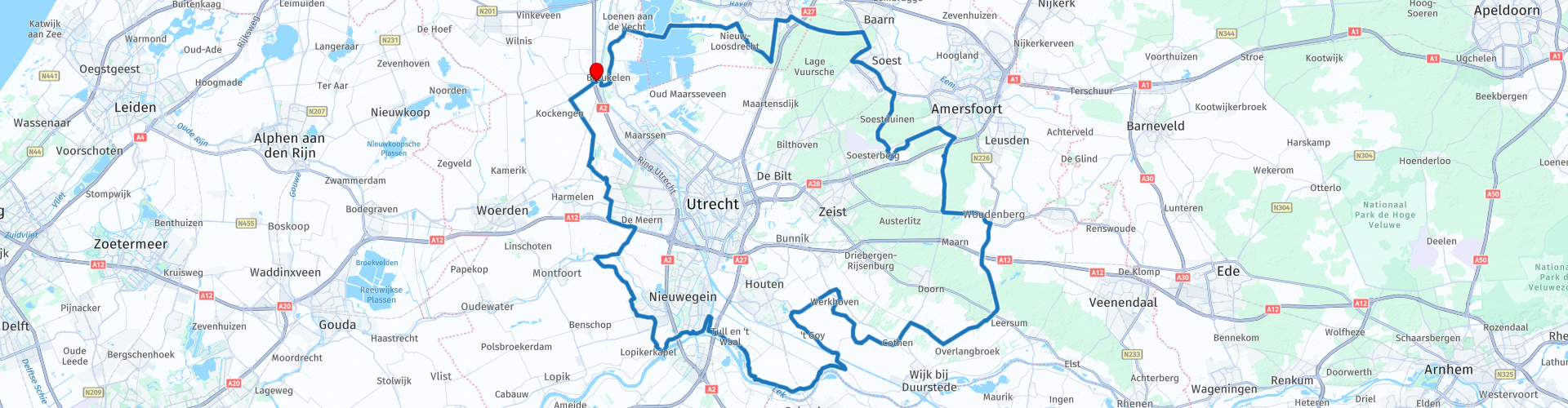
Rondrit Breukelen Utrechtse Heuvelrug en Lage Vuursche

This route was brought to you by:
RouteXpert Dick Schaap
Last edit: 07-03-2023
 Route Summary
 A beautiful route on well-maintained roads. This route deserves more than 5 stars.
Start and end route:
Van der Valk Hotel Breukelen,
Stationsweg 91, 3621 LK Breukelen
 Share this route


Animation

Verdict


Duration
4h 56m

Mode of travel
Car or motorcycle

Distance
144.06 km

Countries

 RouteXpert Review
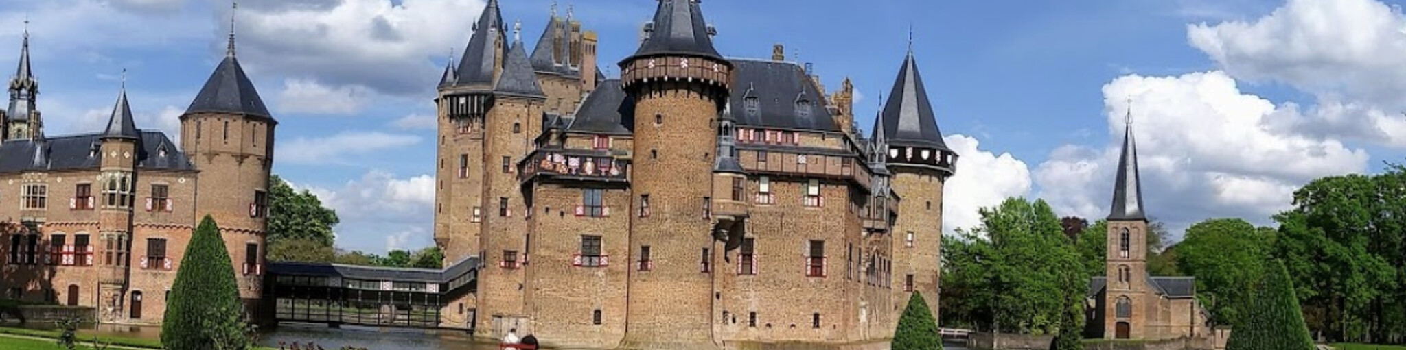
 It goes in the direction of Haarzuilen, past the Gatehouse of Castle De Haar. De Haar is one of the most beautiful and also the largest castle in the Netherlands. It was built from 1892 on the ruins of the old castle. Turn left immediately after the gatehouse to turn around before the gate. There is a nice place to see the gate and to make a photo opportunity of it.
The route then goes over the Parkweg in the direction of Vleuten. Before Vleuten, the Hamtoren with Poortgebouw is passed. Also turn right here to get a good view of the Hamtoren. The Hamtoren is the remnant of Den Ham Castle, located on an old road to Harmelen. It is first mentioned in a charter from 1325. The castle was initially built as a residential tower, probably around the year 1260. In 1536, the States of Utrecht recognized it as a knight's court city, the residents were then admitted to the knighthood. Turn before the tower and back on the route to Vleuten/De Meern.
In Vleuten on the Veldhuizerweg, in the middle of the buildings, the remains of the foundation of a Roman watchtower are marked. After De Meern through the polder towards Montfoort. In the polder, the route turns left for a crossing of the Hollandsche IJssel and continues towards IJsselstein and Nieuwegein.
In IJsselstein it goes right past the Gerbrandytoren, also known as the Zendmast Lopik. It is a tower with a transmission mast for FM radio and television broadcasting, (mobile) telecommunications and data storage. The television transmitter was put into operation on January 17, 1961. At 372 meters, the Gerbrandytoren is the tallest structure in the Netherlands.
In Nieuwegein, the village of Vreeswijk, it is crawling and sneaking through to cross the Princess Beatrix lock on the parallel road. On the Voorhavendijk, along the Lek, before the Voorhaven, the route passes the high earthen embankment of Fort Vreeswijk on the left.
Fort Vreeswijk was built around 1853 and is part of the Dutch Waterline. It is located right next to the Lekdijk. The fort has a rich history. It is hidden in the built-up area of Nieuwegein. Initially, the fort was built by the French in 1672 as a redoubt, composed of low ground walls. Immediately after the Fort is a machine gun casemate on the right. This casemate was also part of the New Dutch Waterline and protected the entrance to the Lek Canal. It was built in 1936.
The Beatrix lock is then crossed over the parallel road, next to the bridge. Here is a nice view of the old lock and the lock gates with a weight of 490,000 kg each. The Beatrix lock is a national monument from 1938 with a renovation and the installation of a 3rd chamber (lock) in 2019.
After the lock, the route passes the Kazemat Vreeswijk Oost. It seems as if this Casemate from 1936 is sinking into the ground. Nothing is less true. The Casemate had to make way for the construction of the 3rd chamber in the Beatrix lock. The 1.2 million kilo heavy bunker was moved over a distance of 150 meters. To clarify that it was newly laid there, it was tilted.
The route now follows the Lekdijk past Fort Honswijk. Fort Honswijk, originally called Fort Willem II, is also a fort of the New Dutch Waterline, built in 1841-1848. Last manned during mobilization for WWII. On May 14, 1940, Fort Honswijk was taken by the German army without a fight. After the Second World War, NSB members and possibly the Three van Breda were imprisoned in Fort Honswijk. The Fort remained in use by the Ministry of Defense until 2012. The Fort is now owned by the municipality of Houten and can be visited freely.
The Lekdijk is followed further to the recreation area Heulsewaard. There is a rest area with a beautiful view of the Lek.
After the break, the route follows a beautiful winding through the polder landscape past 't Goy and Houten to Kasteel Beverweerd. Beverweerd is an originally 13th-century castle and former knight's court town that is located on an island along the Kromme Rijn near the village of Werkhoven. After the castle Beverweerd it goes towards lunch in the town of Cothen. On the way, the route passes the Water Tower of Werkhoven.
NB! After Castle Beverweert there is a short unpaved stretch along the N229 to finally cross the N229.
After lunch the route is picked up by Langbroek towards Doorn and the Utrechtse Heuvelrug. In this beautiful green area it goes past Woudenberg to the Leusderheide. The Leusderheide is a military training area and not accessible. The heath has a military history. After 1954, the Dutch cavalry started intensive tank training here in the context of the Cold War. After the Netherlands put the tanks on sale in 2011, the site is now intensively used by other units stationed around Amersfoort and Soesterberg. The route therefore continues past a number of these barracks; including the major Scheick barracks, Du Moulink barracks, Camp Soesterberg and soldier Ketting Olivier barracks. You can also visit a number of museums and historical collections in these areas, in particular from the Military Administration Corps, the Supply and Transport Troops and the Technical Troops Regiment.
The route follows its way along Soestduinen, through Soest and in Baarn past Soestdijk Palace. From 1937 to 2004, this (former) palace was the residence of Crown Princess and later Queen Juliana (1909-2004) and Prince Bernhard. After this, the route passes the entrance gate of Kasteel de Hooge Vuursche, a former 17th-century country house, now owned by the Heineken Exploitatiemaatschappij.
The next and last part of the route goes past Hilversum and Loosdrecht, through Oud-Loosdrecht with a crossing of the Loosdrecht lakes. On the right you can take a look at Fort Spion. The fort is a defense structure that was built between 1844 and 1847. In 1803 there was already a battery on the site that was part of the Old Dutch Waterline.
After the Loosdrecht lakes, another beautiful part of the route along the Vecht. On this road past Fort Nieuwersluis with a view over the Vecht to the barracks of the Fort.
The route ends again at the Kortrijkse Molen and the van der Valk Hotel Breukelen.


 Links
Links  Usage
Usage Want to download this route?
You can download the route for free without MyRoute-app account. To do so, open the route and click 'save as'. Want to edit this route?
No problem, start by opening the route. Follow the tutorial and create your personal MyRoute-app account. After registration, your trial starts automatically.  Disclaimer
Use of this GPS route is at your own expense and risk. The route has been carefully composed and checked by a MyRoute-app accredited RouteXpert for use on TomTom, Garmin and MyRoute-app Navigation.
Changes may nevertheless have occurred due to changed circumstances, road diversions or seasonal closures. We therefore recommend checking each route before use.
Preferably use the route track in your navigation system. More information about the use of MyRoute-app can be found on the website under 'Community' or 'Academy'.