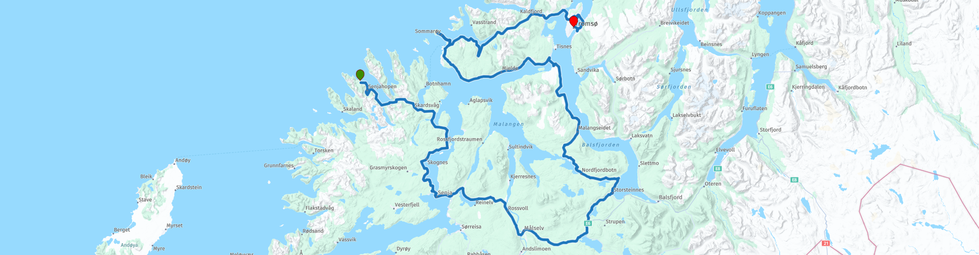
Day 10 North Cape Tour Senjahopen Tromso

This route was brought to you by:
RouteXpert René Plücken (MRA Master)
Last edit: 18-01-2026
 Route Summary
 You drive longer distances in Norway without encountering a gas station or restaurant, keep this in mind before you drive. Make sure your tank is full and bring food and drinks. Bring a few bottles of water or Camel bag and fill it up when you stop to refuel. A number of breaks are scheduled along the way for refueling, eating and drinking.
You have the choice to stay overnight at campsites or in hotels. Hotel prices in Norway are not particularly high and breakfast is usually included. Camping is free almost everywhere, except on private property or where camping is prohibited, indicated by prohibition signs. If you don't want to camp, there are often cabins for rent on the campsites. For a trip through Norway it is always advisable to bring a tent and other camping gear.
I rate this route with 5 ***** Stars because of the beautiful roads, views and bridges. There are not many sights to stop, but there is the possibility to take a nice hike.
 Share this route


Animation

Verdict


Duration
9h 5m

Mode of travel
Car or motorcycle

Distance
321.32 km

Countries

 RouteXpert Review
 If necessary, you can refuel in Senjahopen. There's also a small supermarket there where you can stock up on provisions for the journey.
The journey largely follows the fjord coastline, allowing us to enjoy beautiful panoramas with water on one side and mountains and unspoiled nature on the other. There are several parking areas along the route where you can stop for a picnic, take photos, and enjoy the scenery. The larger parking areas also have restroom facilities. Several of these stops are included in the route.
We'll also be riding through some tunnels. These are quite narrow and can be slippery due to wet conditions, so please be extra careful and considerate of cyclists.
In Silsand, on the island of Senja, we can stop for lunch. There's a restaurant and a snack bar, and the village also has a supermarket where you can buy food and drinks for the journey. This is especially recommended if you plan to hike to Hillesøytoppen; bringing plenty of water is important.
We leave Silsand via the Gisund Bridge (Norwegian: Gisundbrua). This bridge spans the Gisundet Strait and connects Senja with the town of Finnsnes on the mainland. The bridge is 1,147 meters long and has 25 spans, the main span of which is 143 meters. The maximum vertical clearance is 41 meters. Bridges in Scandinavia are often built so high that ocean-going vessels can pass without obstructing road traffic. From this height, you also have a magnificent view of the surrounding area.
On the mainland, we continue along the Fv855 and the E6, through a green and mountainous landscape—no fjords for now. We stop at the Sami Shop Heia souvenir shop, which sells local products. Restrooms are also available.
Then we drive through the Rya Tunnel (Norwegian: Ryaforbindelsen or Ryatunnelen) to the island of Kvaløya. This is an undersea tunnel beneath the Straumsfjorden, between the village of Larseng and the Balsnes area on the mainland. The tunnel is 2,675 meters long, reaches a maximum depth of 87 meters below sea level, and has a maximum gradient of 7.8%.
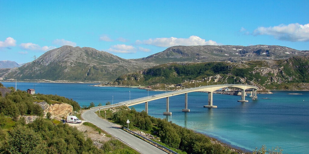
Before crossing the Sommarøy Bridge (Norwegian: Sommarøybrua) from Kvaløya to Sommarøy, we stop to photograph this beautiful bridge. The prestressed concrete bridge is 522 meters long, with a maximum span of 120 meters. The Sommarøy Bridge is equipped with traffic lights to prevent accidents on the narrow bridge. In bad weather, these may sometimes be out of order; in such cases, be extra vigilant for oncoming traffic.
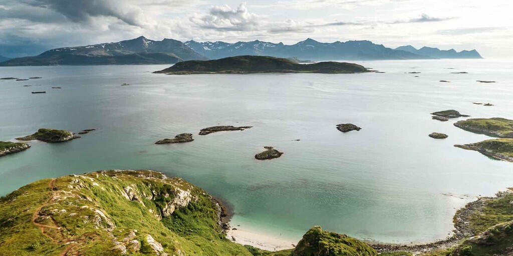
We continue to the youth center on Hillesøy, where we can start the hike to Hillesøytoppen. This is a small mountain—more like a hill, really—with a height of 211 meters, beautifully situated in the sea, just outside Tromsø.
The hike up is quite steep, but not dangerous, and the path is well marked. Along the way, you can choose an alternative route that's less steep and offers breathtaking views of small bays with white beaches and turquoise water. Once at the top, turn left to follow this alternative path. The path runs straight down towards the ocean, after which you turn left towards the houses on Sommarøy and then walk back to the parking lot.
After the hike, we'll return the same way, crossing the Sommarøy Bridge and continuing our route for the final 65 kilometers to our final destination, Tromsø. There will be a stop for fuel and refreshments along the way. We'll travel from Kvaløya to the island of Tromsøya via the Sandnessund Bridge (Norwegian: Sandnessundbrua).
In Tromsø, you can stay overnight in one of the many hotels in the city center or at Tromsø Camping. Tromsø is also known as the "Paris of the North" and offers a wealth of activities and sights. It's definitely worth staying here for several days.
 Links
Links  Usage
Usage Want to download this route?
You can download the route for free without MyRoute-app account. To do so, open the route and click 'save as'. Want to edit this route?
No problem, start by opening the route. Follow the tutorial and create your personal MyRoute-app account. After registration, your trial starts automatically.  Disclaimer
Use of this GPS route is at your own expense and risk. The route has been carefully composed and checked by a MyRoute-app accredited RouteXpert for use on TomTom, Garmin and MyRoute-app Navigation.
Changes may nevertheless have occurred due to changed circumstances, road diversions or seasonal closures. We therefore recommend checking each route before use.
Preferably use the route track in your navigation system. More information about the use of MyRoute-app can be found on the website under 'Community' or 'Academy'.