Day 01 North Cape Tour Oslo Geiranger

This route was brought to you by:
RouteXpert René Plücken (MRA Master)
Last edit: 06-04-2021
 Route Summary
 You drive longer distances in Norway without encountering a gas station or restaurant, keep this in mind before you drive. Make sure your tank is full and bring food and drinks. Bring a few bottles of water or Camel bag and fill it up when you stop to refuel. A number of breaks have been planned along the way for refueling, eating and drinking.
You have the choice to spend the night at campsites or in hotels. Hotel prices in Norway are not particularly high and breakfast is usually included. Camping is free almost everywhere, except on private property or where camping is prohibited, indicated by prohibition signs. If you don't want to camp, there are often cabins for rent on the campsites. For a trip through Norway it is always advisable to bring a tent and other camping gear.
I rate this route with 4 **** stars because of the beautiful roads, beautiful nature and some beautiful places to stop.
 Share this route


Animation

Verdict


Duration
11h 0m

Mode of travel
Car or motorcycle

Distance
434.09 km

Countries

 RouteXpert Review
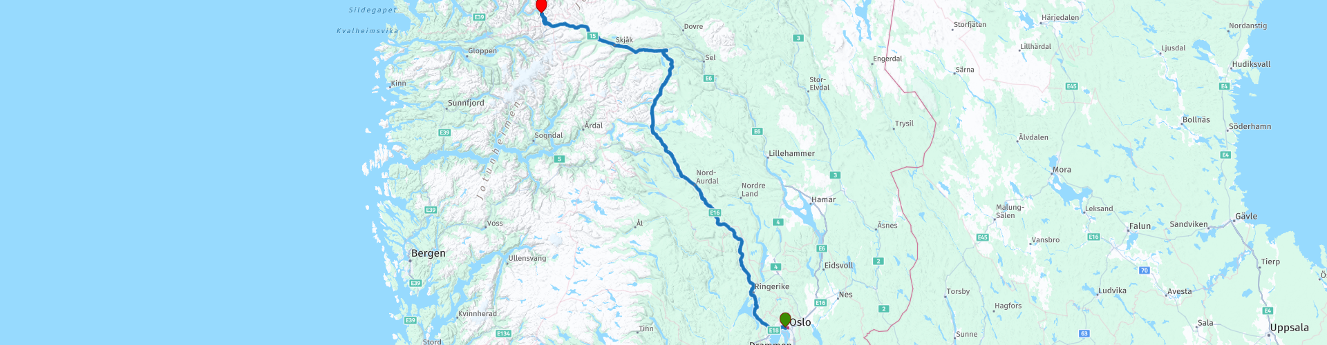
 We leave the town and drive to Sandvika where we take the E16 to the North, on the left side we have an occasional view of the beautiful Tyrifjord. At RP4 we can alternatively take the coastal road Fv155, which winds along the coast of the Tyrifjord.
After about an hour's drive, there is an opportunity to stop at RP6 for a cup of coffee with a sandwich and enjoy the view of the Tyrifjord.
We drive on and follow the course of the river Ådalselva that flows into the lake Sperillen (RP9). Sperillen is a lake in the Norwegian province of Viken. It is located in the Ådal in the municipality of Ringerike and is Norway's 33rd largest lake with an area of approximately 37 km². The lake is 123 meters at its deepest point and it is 150 meters above sea level. While driving along the lake you can enjoy the beautiful panorama.
Lunch is scheduled at Valdresporten Cafeteria (RP10). After this stop we continue along the river Begna further to the North, a beautiful road through the rolling green landscape with its characteristic red wooden houses.
In Bagn (RP11) you can either go straight through the tunnel (4.5km) to gain time, it is better to follow this beautiful route to take the nicer E16-Valdresvegen. Adventure Bike riders can then turn left at RP12 onto Reinlivegen to the next Restaurant (RP15), parts of this road are unpaved, so not suitable for road bikes.
At RP14 you have a nice view of the Strondafjorden, this is a lake that is located in the municipality of Nord-Aurdal and Vestre Slidre in the province of Innlandet, Norway. The lake is part of the Begna basin. The northwestern end of the lake is traversed by the Ulnes Bridge. It has an area of 13.24 km² and is 46.01 km around. It is located at an altitude of 355 m above sea level.
At RP15 we stop to refuel and here is also the opportunity to have a drink and eat at The Scandinavian Restaurant “Fagernes Gjestegård” across the street from the gas station. Other options for something to eat are also in the towns of Beitostølen (RP20) about 30km, Lom (RP24) about 140km or at Grotli Høyfjellshotel (RP25) about 200km.
At RP26 we turn right to drive to Dalsnibba (RP27), the highest European fjord view and the Geiranger Skywalk. It is about 1500m drive from the route and well worth a visit. The view is truly spectacular. Here we have a beautiful view over the snow-capped mountains and the Geirangerfjord, part of the West Norwegian fjords that are a UNESCO World Heritage Site. The way up is open from May to October. Opening times may vary slightly depending on weather conditions. Here you have to pay toll. Those who want to skip this part of the route can continue to the end point.
The end of the journey is in Geiranger, where there are several campsites and hotels to stay overnight. But before we arrive here we are treated to a beautiful mountain road (Fv63) with lovely hairpin bends and a nice viewpoint at RP29, Stop to admire the view of the Flydalsjuvet viewpoint. Flydalsjuvet offers an impressive view and is an excellent point to take beautiful pictures of Geiranger and the Geirangerfjorden with the many cruise boats.


 Links
Links  Usage
Usage Want to download this route?
You can download the route for free without MyRoute-app account. To do so, open the route and click 'save as'. Want to edit this route?
No problem, start by opening the route. Follow the tutorial and create your personal MyRoute-app account. After registration, your trial starts automatically.  Disclaimer
Use of this GPS route is at your own expense and risk. The route has been carefully composed and checked by a MyRoute-app accredited RouteXpert for use on TomTom, Garmin and MyRoute-app Navigation.
Changes may nevertheless have occurred due to changed circumstances, road diversions or seasonal closures. We therefore recommend checking each route before use.
Preferably use the route track in your navigation system. More information about the use of MyRoute-app can be found on the website under 'Community' or 'Academy'.