03 Christchurch to Omarama

This route was brought to you by:
RouteXpert Nick Carthew - (MRA Master)
Last edit: 04-05-2021
 Route Summary
  Share this route


Animation

Verdict


Duration
9h 22m

Mode of travel
Car or motorcycle

Distance
431.07 km

Countries

 RouteXpert Review
 Don’t you just love that feeling when you’re all packed up and heading down your driveway about to embark on a road trip. Freedom, adventure, escapism, fun; this route encapsulates all of these.
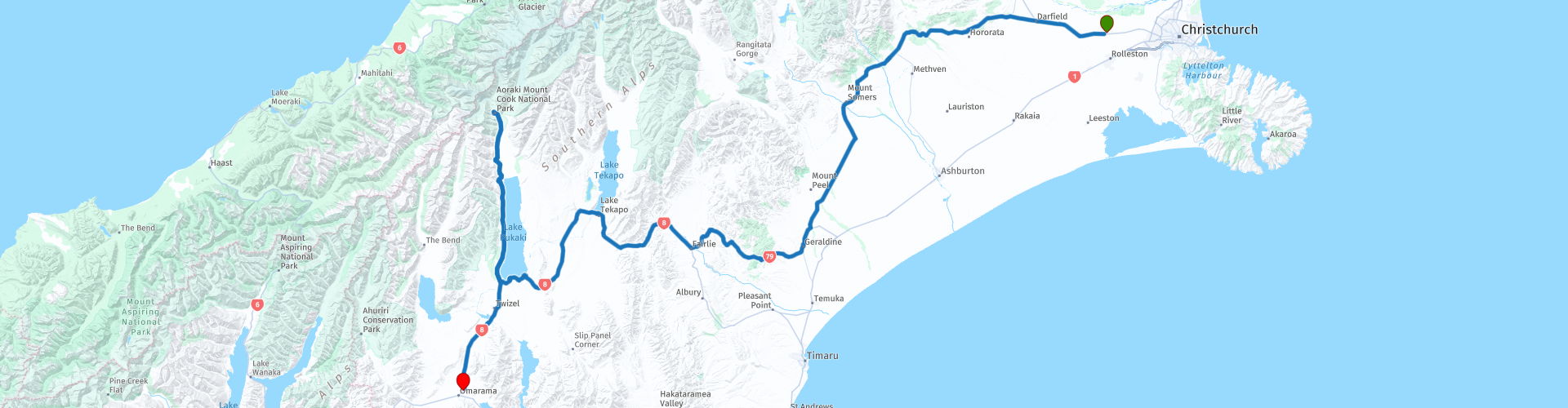
Leave Christchurch heading west using the Inland Scenic Route 72 to Geraldine, you soon feel a sense of openness with the Southern Alps right in front of you and spacious farmland all around.
This road is a delight to travel on and you'll soon be at the historic Rakaia Gorge bridge. Constructed between 1880 and 1882, the Rakaia Gorge Bridge is made of wrought iron and timber and only wide enough for single vehicles. The 55-metre single span bridge, features a timber deck and handrail atop its wrought iron plate girder and truss. This unconventional truss has no bottom chord and its ties fan out from the gorge’s edge carrying the load forces to the bridge’s anchors. The Rakaia Gorge Bridge also has significance as one of the oldest wrought iron bridges in New Zealand. It's definitely worth a photo stop as the views of the turquoise braided Rakaia river and Southern Alps are stunning.
The Mt Hutt Range dominates your view for the next few kilometers as you make your way to Geraldine.
Geraldine is a pretty country town set among exotic trees alongside the meandering Waihi River. It is a town with a strong artistic streak which is reflected in the variety of boutique shops offering unique art, crafts and giftware. The Barkers Foodstore and Eatery is a foodies delight. A modern and relaxing cafe with a unique sampling concept. As you walk in all the dips, chutneys, jams and juices are laid out and ready to sample. What’s not to like about that! I have suggested a coffee stop and maybe some takeaways here.
The ride from Geraldine to Lake Tekapo is superb. The road becomes bendy and hilly now as you leave the Canterbury Plains and get into the foothills of the Southern Alps. Lots of green to start with that slowly turns to tussock. Since the end of 2016, Mount Cook Road and the State Highway number 8 connecting Fairlie to Twizel have been officially renamed “Starlight Highway” in order to make the region an internationally go-to place for stargazing. In 2012, a 4300 sq km area around Twizel, Tekapo and Aoraki/Mount Cook National Park was also classified as a “Dark Sky Reserve”, with the intent of controlling light pollution and restricting the use of artificial light. It’s the biggest of its kind in the world, and the only one in the Southern Hemisphere.
Next is the historic village of Burkes Pass, located between Fairlie and Lake Tekapo, on the ‘pass’ or route discovered by Europeans in 1855 leading to vast inland plains to graze their sheep. A totally unexpected experience described in Lonely Planet as a ‘must see’ is Three Creeks, where retro collectables, artwork, furniture, great coffee and conversation can be found in a general store surrounded by classic cars, a 1950’s service station and memorabilia. I've suggested another coffee stop here even though it's only an hour on from the last stop - in my eyes you can never have too much coffee!
The village was the last outpost of civilization for Europeans in the early days and has remained relatively unchanged since. The early pioneers, who came to graze their sheep in this area, built a tiny wooden church, opened in 1872, now the oldest union church in New Zealand.
The pass leads you closer to the mountains and to Lake Tekapo.
Lake Tekapo is the second-largest of three roughly parallel lakes running north–south along the northern edge of the Mackenzie Basin, it covers an area of 83 square kms, and is at an altitude of 710 m above sea level. It is perhaps one of the most beautiful sights in the whole of New Zealand. Lake Tekapo is also one of the sunniest places in New Zealand with annual sunshine hours averaging more than 2,400 each year. A photo stop here is a must.
40 kms further on is Lake Pukaki, the twin brother of Lake Tekapo: the same extraordinary turquoise colour, surrounded by the same beautiful mountains. There's one thing that might make this view even better though: on a clear day, you can see the silhouette of Mount Cook (or its Maori name Aoraki), the highest mountain of New Zealand (3724m).
This route now follows the bank of Lake Pukaki to the village of Mount Cook for lunch. On the way, don’t miss the Alpine Lavender farm a free entrance, allowing you to walk between the rows of lavender, breathe the lovely smell and observe the bees flying from one flower to another. Then Peter’s lookout, where you would be able to take a perfect postcard picture of the road, the lake and the majestic mountain in the background.
Mount Cook village sits amongst sky-scraping peaks, phenomenal glaciers, permanent snow and all beneath a stunning star-studded sky. The village is at the base of New Zealand’s highest mountain, Aoraki/Mount Cook. This dazzling peak, known to Māori as Aoraki or Cloud Piercer, is one of 28 mountains in this alpine backbone which peak at over 3,050 metres, and hundreds of others not far short of that all making up the famous Southern Alps. Enjoy your lunch here surrounded by the breathtaking beauty of the Southern Alps.
The road back from the village, although it's the same road, the views are completely different. From Mt Cook village to the end of the route at Omarama is approximately 1½ hours, enjoy this outstanding landscape.
Nestled in a broad basin between mountain ranges, Omarama is well known to glider pilots. Omarama means the place of light and glider pilots love the air above the small township near the southern end of the Mackenzie Basin.
As a junction town, Omarama is naturally a great place to stop and stay if you're coming from Christchurch. I have included some links for accommodation below this review.
After a long day travelling, have a relaxing soak in a private hot tub filled with pure mountain water at Hot Tubs Omarama under the starry night sky. Maybe even stop for two nights and have a flight in a glider to see this stunning landscape from the air.
Whatever you decide, enjoy.


 Links
Links  Usage
Usage Want to download this route?
You can download the route for free without MyRoute-app account. To do so, open the route and click 'save as'. Want to edit this route?
No problem, start by opening the route. Follow the tutorial and create your personal MyRoute-app account. After registration, your trial starts automatically.  Disclaimer
Use of this GPS route is at your own expense and risk. The route has been carefully composed and checked by a MyRoute-app accredited RouteXpert for use on TomTom, Garmin and MyRoute-app Navigation.
Changes may nevertheless have occurred due to changed circumstances, road diversions or seasonal closures. We therefore recommend checking each route before use.
Preferably use the route track in your navigation system. More information about the use of MyRoute-app can be found on the website under 'Community' or 'Academy'.