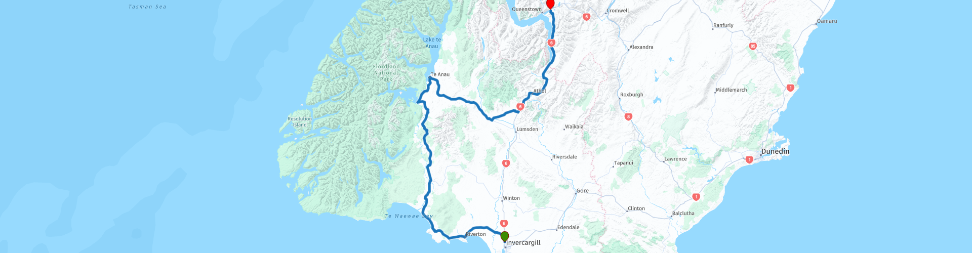
06 Invercargill to Queenstown

This route was brought to you by:
RouteXpert Nick Carthew - (MRA Master)
Last edit: 04-05-2021
 Route Summary
 This route travels along the edge of the unique Fiordland National Park and then on to Lake Wakatipu along the Southern Scenic Route. Never far away from the majestic Southern Alps. Exceptional views and landscapes await you on very good roads with lots of excellent attractions. It's another 5***** star route to join the others in this tour.
 Share this route


Animation

Verdict


Duration
7h 19m

Mode of travel
Car or motorcycle

Distance
348.40 km

Countries

 RouteXpert Review
 Starting from a fuel station with a full tank of fuel, you'll soon be travelling through fields of rich pasture on the Southern Scenic Route (SSR). The previous route of this tour 05, joined the Southern Scenic Route at Dunedin and this route takes you to the other end at Queenstown.
The Southern Scenic Route is a road trip like no other.
This incredible journey has been ranked one of the top 10 drives of the world, and for good reason. It is just over 600 km of spectacular natural and cultural attractions. Picturesque coastlines, remote beaches, lush native rainforests, pristine lakes and stunning mountain vistas are just some of the highlights along this epic route. It is an ideal drive for those who want to explore everything southern New Zealand has to offer.
Thirty kms from Invercargill is the seaside town of Riverton, one of the most popular towns in Western Southland and is a great stop on the Southern Scenic Route. The township is nestled at the western end of Oreti Beach, set in a picturesque location that spans Jacob’s River Estuary, the fondly named “Riviera of the South”. Nearly 200 years old, Riverton (Aparima) is the oldest Pākehā settlement in Southland and one of the earliest European settlements in New Zealand. Pākehā is a Māori-language term for New Zealanders primarily of European descent.
A short ride from here takes you to McCracken's Rest.
McCracken's Rest is a lookout and rest area perched on the edge of the cliff with commanding views of Te Waewae Bay and the tiny one million year old Solander Islands, formed by the eroded skeleton of a volcano. According to Maori legend, the Solanders are the broken tooth and crumbs tossed aside by Kewa the whale, when it chewed between Stewart Island (Rakiura) and the mainland. You may even catch a glimpse of New Zealand’s largest pod of Hector’s Dolphins! McCracken's Rest is the perfect place to pause in your journey to take in the scenery and fresh air, and of course to take the classic traveller's photo in front of the signpost. This is the last you'll see of the sea as the route now turns north and heads inland.
Another short ride sees you arriving at Tuatapere for a coffee break.
Tuatapere not only sits on the edge of wilderness amid spectacular unspoilt scenery and lush rolling farmland. It is the launch pad to accessing the variety of natural environments and adventure activities in Western Southland, including world-class jet boating and hiking. Lying on the Southern Scenic Route, it is an increasingly well-travelled place to stop.
Tuatapere has a rich sawmilling history and is home to a fascinating logging museum, along with many other quaint reminders of the town’s pioneering history. The tranquil town of Tuatapere built around the Waiau River is where the Southern Scenic Route was originally conceived and is also the homebase for the World Famous Tuatapere Sausage, the town is known as the sausage capital of New Zealand!
Another short ride (this route is a collection of these!) and you'll be crossing the Waiau River with a view of the historic Clifden Suspension Bridge to your left.
The historic Clifden Suspension Bridge was an important transport link in what was a relatively remote part of Southland; opening up of the area east of the Waiau River. It was built in 1898-99 to replace a punt which had operated since the early days of settlement. At that time the Waiau River was often swift and dangerous, but the flow has since been severely reduced by hydroelectric development on Lake Manapouri.
Staying on the SSR, you're carried closer and closer to the mountains on what has been up until now, a relatively flat road. A section of twisty bends that continuously climb takes you over Blackmount and then gently back down on the other side. The snow capped Hunter Range of mountains are on your left with the less dramatic Takitimu mountains to your right as you head for Lake Manapouri.
Nestled amongst the Kepler Mountains, Turret Range and the Hunter Mountains, Lake Manapouri and surrounds offer stunning scenery and numerous activities to enjoy. Often described as New Zealand’s most beautiful lake, Lake Manapouri has stunning sandy beaches and her deep blue waters can make you feel like you are on a pacific island, not in the deep south of New Zealand. Measuring 444 metres deep, the lake is New Zealand’s second deepest. Formed by a glacier, Lake Manapouri has been cut deep into the ground - the bottom of the lake now lies 267 metres below sea level.
A short ride from here is the town and lake sharing the same name; Te Anau.
The picturesque township of Te Anau is the main visitor base for the glacier-carved wilderness that is Fiordland National Park making it a natural place for another coffee stop,
Lake Te Anau is the largest body of freshwater not only in NZ but the whole of Australasia, stretching 65 km south to north, with three deep arms spreading west into Fiordland National Park wilderness. The lakes of Te Anau and Manapouri are connected by the mighty Waiau River.
Turning away from Fiordland the route passes through the foothills of the Livingstone and Eyre mountains to the north with the Takitimu mountains south of you as you head towards the small town of Mossburn for lunch.
A conspicuous stag monument proclaims Mossburn ‘the venison capital of the world’. New Zealand’s first deer farm was established nearby in 1972 and a game-processing works has been in operation since 1962. Venison burger for lunch?
An hours ride after lunch and you'll be crossing the regional border from Southland to Otago and arriving at Kingston on the southern tip of Lake Wakatipu. Kingston is home to The Kingston Flyer.
The Kingston Flyer is New Zealand's famous vintage steam train set in the spectacular mountain scenery of the Queenstown Lakes District. When gold was discovered in the Wakatipu district in 1862 the need to connect the district by steamships and steam trains became apparent. The railway line at last reached Kingston on July 10, 1878 and a public holiday was declared by Queenstown Borough and Lake County Councils.
Sadly, the service was replaced by buses and passenger numbers declined through the 1950's. The final Kingston Flyer operated during the Easter holiday of 1957.
Several attempts at restoration have been thwarted but the good news is; all going well, the Kingston Flyer will be operating again on the 14 km stretch of track from Kingston to Fairlight by November 2022.
I mentioned that Kingston was on the southern tip of Lake Wakatipu, well in my opinion the lake is the jewel in the crown of this route. Lake Wakatipu fills a deep valley carved into the mountains by ancient glaciers. Shaped like a lightning bolt and with a length of 80 km, it is New Zealand's longest lake. Because of its unusual shape, Lake Wakatipu has a 'tide' (more correctly, an unusually large seiche or "standing wave"), which causes the water to rise and fall about 10 centimetres every 25 minutes or so. Maori legend links this phenomenon to the heartbeat of a huge monster named Matau, who is said to be slumbering at the bottom of the lake.
The SSR is known as The Devil's Staircase because of the undulations in the road as it runs alongside the lake offering breathtaking views. You'll never forget riding The Devil's Staircase!
The end of the route is at a McDonald's in Frankton just 5 km from Queenstown. I ended the route here to enable you to have a coffee while you work out where your accommodation is. Queenstown is very popular as a holiday destination so the choice of accommodation is almost endless. I have included a few links below this review. Queenstown accommodation ranges from cosy backpacker dorms to world-class luxury lodges. Most places to stay have great views and easy access to nearby activities. Staying in downtown Queenstown will ensure you are close to the thriving nightlife and many excellent restaurants of the town.
Out in the Gibbston, you'll find places to stay in vineyards, while in the direction of Glenorchy there are plenty of bed and breakfasts and boutique lodges along the lakefront.
Arrowtown is 15 minutes away from central Queenstown and offers a quieter and often cheaper alternative to the hustle and bustle.
Wherever you choose to stay - enjoy.


 Links
Links  Usage
Usage Want to download this route?
You can download the route for free without MyRoute-app account. To do so, open the route and click 'save as'. Want to edit this route?
No problem, start by opening the route. Follow the tutorial and create your personal MyRoute-app account. After registration, your trial starts automatically.  Disclaimer
Use of this GPS route is at your own expense and risk. The route has been carefully composed and checked by a MyRoute-app accredited RouteXpert for use on TomTom, Garmin and MyRoute-app Navigation.
Changes may nevertheless have occurred due to changed circumstances, road diversions or seasonal closures. We therefore recommend checking each route before use.
Preferably use the route track in your navigation system. More information about the use of MyRoute-app can be found on the website under 'Community' or 'Academy'.