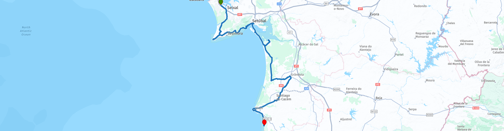
Corroios near Almada to Porto Covo

This route was brought to you by:
RouteXpert Nick Carthew - (MRA Master)
Last edit: 23-12-2020
 Route Summary
  Share this route


Animation

Verdict


Duration
5h 31m

Mode of travel
Car or motorcycle

Distance
217.91 km

Countries

 RouteXpert Review
 Starting from a McDonald's in Corroios, you will soon be leaving the busy town behind you and you'll be travelling through sandy soil and pine trees as the route heads towards Cape Espichel.
The Cabo (Cape) Espichel is a wild and barren headland on the southwestern tip of the Setubal Peninsula. This is a dramatic region formed of wind-blasted landscapes and towering cliffs, which are ceaselessly pounded by the ferocious Atlantic Ocean.
As you approach the cliffs and with the lighthouse in view, you'll see an ancient aqueduct serving The Sanctuary of Our Lady of Cape Espichel.
There are five major tourist attractions at the Cabo Espichel:
• The Santuario de Nossa Senhora and the pilgrim’s accommodation (Sanctuary of Our Lady of Cape Espichel).
• The lighthouse (Farol do Cabo Espichel).
• The small Chapel or hermitage of Ermida da Memória.
• The Pedra da Mua dinosaur tracks.
• The Lagosteiros dinosaur footprints.
Along this exposed & weathered coastline are 2 different sets of tracks; one from the Late Jurassic (called the Pedra da Mua) and one from the Cretaceous period (the Jazidas de Lagosteiros). It is fascinating to realise that these 2 sets of prints are separated by a distance of less than 500 m, but span a time of almost 50 million years. The dinosaur tracks are a 20 minute walk along the cliffs but for any paleontologists, the short walk is worth it. The desolate cliffs of Cabo Espichel have always spurned superstition and medieval customs, which, after the Christian Crusades of Portugal (1170s), slowly amalgamated into the Order of Our Lady of Cabo Espichel. The Espichel coastline was the setting for multiple miracles and religious visions, and this ensured the region remained an important pilgrimage destination during the 13th-18th centuries.
The most fascinating vision occurred in the 15th century, when an apparition of the Virgin Mary appeared riding a giant mule, and ascended the steep cliffs from the ocean. On reaching the top of the cliffs (and more significantly the Chapel of Ermida da Memória) Mary vanished, leaving just the footprints of the giant mule. These giant mule tracks actually do exist, and can be seen as part of the Pedra da Mua, originally being formed by a huge Sauropod dinosaur.
There is a small cafe here for a coffee break before moving on.
Next comes that short section of gravel road, it's well maintained and even novice riders shouldn't have any problems. This leads to a great road high above the sea that offers spectacular views all along it, with many viewpoints to stop and take photos. The road leads you to Setubal.
Setubal is a busy working port and major commercial fishing centre, which unashamedly does not try to mask its heritage and history. Setubal is a destination that will polarise tourists, some will adore the raw character and intriguing sights, while others will despise the gritty industrial nature of the city. Setubal is a city that has always had a close connection to the sea, and this is celebrated along the newly rejuvenated waterfront, which encompasses the colourful fishing harbour, the popular urban park and the Troia Peninsula ferry terminal. Within the charming historic centre is a maze of narrow alleys, hidden plazas, and family-owned shops, along with Portugal’s largest fish market. I have suggested a lunch stop here where you can eat the freshest sardines that you'll ever taste. Or try the local speciality of choco frito (fried cuttlefish) in one of the restaurants that line the harbour front.
After lunch you hop on the ferry for a short voyage across the Sado River to the Troia Peninsula. Prices in 2020 are 9,90€ for a motorcycle. No need to book, just turn up.
The Tróia Peninsula is a 13 mile long, narrow sand spit that offers tranquil pine forests and some of the best beaches in the area.
There is a Rice Museum at RP 23 where you can learn about the history of rice production in this region. You will see some of the paddy fields as you visit Carrasqueira and the wooden shacks built on stilts. A very beautiful scene and a great place for some photography. This wild place has long been kept secret by regular visitors, who appreciate the ‘tranquilidade’ of this distinctive region. And although spending holidays here is becoming more and more ‘trendy’, make no mistake, this isn’t the new Ibiza. This is the epitome of slowness and simplicity; a little corner of paradise, suspended between the ocean and the rice paddies.
Then it's more pine forest until you reach the small town of Mendes where the route heads east to enjoy the mountain-like road that leads to the town of Grandola. The route turns around here and travels back to the coast but if you wanted to visit, it's just a case of taking another exit from the roundabout.
The road back to the coast is the N120 and this passes through areas that have a lot of ancient history attached to them. At RP 29 you can see the remains of a small Roman dam and when you reach the town of Santiago do Cacém there are substantial Roman ruins to visit.
Next comes the coastal town of Sines.
Sines is an industrial town dominated by its oil refinery with its towers and pipelines, and the deep sea port with its huge container ships and tankers. This offers a complete contrast to the previous areas that this route travels through and there are plenty of things to see as you travel around the extremity of the town.
A short section of coastal road with great views takes you to the end of the route at Porto Covo.
If the archetypal traditional Portuguese fishing village still exists then maybe Porto Côvo is this. Even the name translates as port of the fishing net. A jumble of whitewashed cottages, cobbled streets and pretty squares perched on the low cliff tops of the Alentejo coast. Porto Côvo is undoubtedly pretty but these days it is perhaps best to describe it as a former fishing village since the village's economy is now driven by tourism. At the heart of Porto Covo is the attractive cobbled square of Praça Marquês de Pombal which is a nod to the great architect of Lisbon's downtown grid layout, which to a very minor degree has been implemented in this section of Porto Côvo. Unsurprisingly, all roads in the old village lead to the little fishing harbour which clings to the side of a deep natural inlet. A few boats still fish from here but much of the traffic is from boat trips out to and around the nearby Ilha do Pessegueiro.Translating as Peach Tree Island the actuality of this treeless island is somewhat less romantic than it sounds. Located around 300 metres offshore the island is of some historical interest and is home to both a 15th century fort and Roman ruins.
I have included a link below this route to a rather nice hotel.


 Links
Links  Usage
Usage Want to download this route?
You can download the route for free without MyRoute-app account. To do so, open the route and click 'save as'. Want to edit this route?
No problem, start by opening the route. Follow the tutorial and create your personal MyRoute-app account. After registration, your trial starts automatically.  Disclaimer
Use of this GPS route is at your own expense and risk. The route has been carefully composed and checked by a MyRoute-app accredited RouteXpert for use on TomTom, Garmin and MyRoute-app Navigation.
Changes may nevertheless have occurred due to changed circumstances, road diversions or seasonal closures. We therefore recommend checking each route before use.
Preferably use the route track in your navigation system. More information about the use of MyRoute-app can be found on the website under 'Community' or 'Academy'.

Setubal
About this region
Setúbal (, US also , Portuguese: [sɨˈtuβal, -βɐl] (listen); Proto-Celtic: *Caetobrix) is a city and a municipality in Portugal. The population in 2014 was 118,166, occupying an area of 230.33 km2 (88.9 sq mi). The city itself had 89,303 inhabitants in 2001. It lies within the Lisbon metropolitan area.
In the times of Al-Andalus the city was known as Shaṭūbar (Andalusian Arabic: شَطُوبَر [ʃeˈtˤuːbɑr]). In the 19th century, the port was called Saint Ubes in English, and Saint-Yves in French.
The municipal holiday is 15 September, which marks the date in 1860 when King Pedro V of Portugal officially recognised Setúbal as a city.
Read more on Wikipedia
In the times of Al-Andalus the city was known as Shaṭūbar (Andalusian Arabic: شَطُوبَر [ʃeˈtˤuːbɑr]). In the 19th century, the port was called Saint Ubes in English, and Saint-Yves in French.
The municipal holiday is 15 September, which marks the date in 1860 when King Pedro V of Portugal officially recognised Setúbal as a city.
View region
 Statistics
  1
1Amount of RX reviews (Setubal)
 9270
9270Amount of visitors (Setubal)
 31
31Amount of downloads (Setubal)