D09 Sandpoint Colville

This route was brought to you by:
RouteXpert Hans van de Ven (Mr.MRA)
Last edit: 02-05-2021
 Route Summary
 The roads are very good, the surroundings beautiful, enjoy the many lakes along the way and a stop along the glittering chain created by the Little Pend Oreille River is a must.
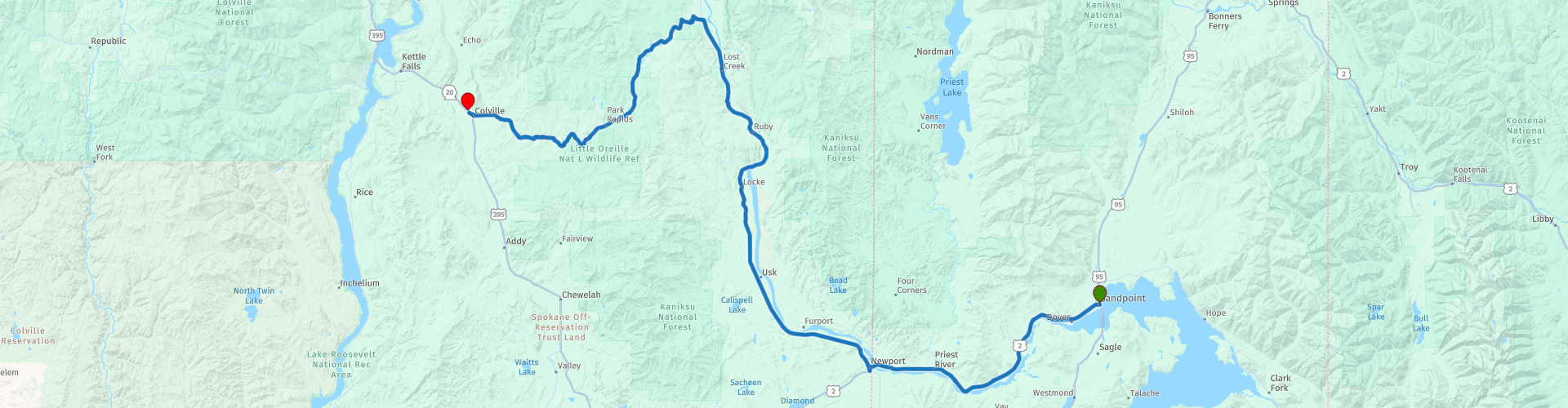
Starting point: Best Western Edgewater Resort
End point: Comfort Inn Colville
The route has been made the same for TomTom, Garmin and MyRoute-app Navigation users.
Thanks to Richard & Lisa for the information!
 Share this route


Animation

Verdict


Duration
4h 7m

Mode of travel
Car or motorcycle

Distance
182.30 km

Countries

 RouteXpert Review
 The Bitterroot Salish (or Flathead, Salish, Selish) are a Salish-speaking group of Indians and one of the three tribes of the Confederated Salish and Kootenai Tribes of the Flathead Nation in Montana.
The Flathead Reservation is also the home base for the Kootenai and Pend d'Oreilles tribes. Bitterroot Salish of Flathead originally lived in an area west of Billings, Montana that extends to the continental gorge in the west and south of Great Falls, Montana that extends to the border between Montana and Wyoming. From there they later went west to the Bitterroot Valley. Upon request, a Catholic mission was built here in 1841. In 1891 they were forcibly moved to The Flathead Reservation.
-----
The Pend d'Orille, also known as the Kalispel, are indigenous peoples of the Northwest plateau. Today, many of them live in Montana and eastern Washington. The Kalispel peoples referred to their primary tribes as Kaniksu.
Their traditional territory was along the banks of the Flathead River, Clark Fork and Pend Oreille rivers. It stretched from the current Plains, Montana, westward along the Clark Fork River, to Lake Pend Oreille and Priest Lake in Idaho, and the Pend Oreille River (Ntxwe, meaning "river") in East Washington and into British Columbia (Canada).
They traditionally lived in many tribes, originally probably eleven tribes, and are generally geographically and culturally divided into two groups:
1. The "upstream people" or Upper Kalispel (or "Upper Pend d'Orille") are commonly called the Pend d'Oreille. They were also known as Kullyspelm or Ql̓ispé ("Camas People") and are now registered in the federally recognized Confederated Salish and Kootenai Tribes of the Flathead Nation in Montana.
2. The "downstream people" or Lower Kalispel (or "Lower Pend d'Orille") are commonly called the Kalispel. They were also known as Silkatkmlschi or Sɫq̓etkʷmsčin̓t ("People who live along the banks of the broad water") because they were located around Lake Flathead (Čɫq̓étkʷ - "Broad water"). Today they are enrolled in the Kalispel Tribe or Indians in Washington and some families are part of the Coeur d'Alene Tribe in Idaho.
Some Kalispel are registered in the Confederated Tribes of the Colville Reservation in East Washington. Prior to colonization by European Americans, Chewelah was home to a band of the Lower Kalispel people. The band was known as the Slet̓éw̓si, meaning "valley people". The Chewelah Band of Indians is currently part of the Spokane Tribe of Indians of Washington.
-----
Kootenai, historically, Kootenai tribes occupy areas along the Kootenai River in parts of Montana, Idaho, and British Columbia. Although they did not share a common language with another group, they were closely associated with the Flatheads and the Kalispel Pend Oreilles through common areas and marriages. Their lifestyle depended on hunting, fishing and collecting carrots and berries. The mainstay of their diet was salmon, starchy roots and bulbs. Their culture was semi-nomadic, with permanent winter villages in the vicinity of good fishing spots. Their social structure was based on the extended family groups. Clothing was made from woven bark and plant fibers; Lodges were conical huts built from a pole frame covered with storm mats. Basketry supplies most utensils, including cups, bowls and storage bags. As with other tribes, the Dawes law of 1877 lost the popular allocations and the popular assignments they had received from the 1855 Convention. Much of their original territory is now in the hands of non-Indians. They currently live on a reservation of 2,695 hectares. They operate under a constitution written after the Wheeler-Howard Act.
In this 4-star route you will drive along beautiful good roads, and through a beautiful environment, culture sniffing in the Indian reservation where you will certainly stop 1 or more times.
History:
John Work, an agent for The Hudson's Bay Company, founded Fort Colvile near the fur trade Kettle Falls in 1825. It replaced the Spokane House and the Flathead Post as the main trading center on the Upper Columbia River.
Americans also wanted to operate in this territory. The border dispute in Oregon (or the Oregon issue) arose in the first half of the 19th century as a result of competing British and American claims on the Pacific Northwest. It was governed by the Oregon Treaty of 1846, which laid the new border between Canada and the United States on the 49th Parallel, north of Fort Colville. The post was used for some time as a center for mining and transport / supply support in connection with gold rush in the 1850s and 1860s, especially with the Holcomb Valley Gold Rush in California. After it was abandoned in 1870, some buildings stood until late in 1910. The site was flooded by Lake Roosevelt after the construction of the Grand Coulee Dam on the Columbia River.
The Kettle Falls archaeological district, including 17 pre-contact sites, as well as Fort Colville and St. Paul's Mission, were added to the National Register of Historic Places in 1974. Some archaeological studies were done in the 1960s when the lake was lowered for additional dam construction and others were undertaken. The district is very important for pre-contact and later native American and American history.
In 1859, the US Army established a new Fort Colville in Pinkney City, Washington, about 3 miles NE of the current city of Colville. That fort was abandoned in 1882. At the end of 1871, with the resolution of Hudson's Bay Company land claims, Governor Edward Selig Salomon ordered John Wynne to accept those countries, including those currently part of the city of Colville. Urban development moved to its current location in the Colville River Valley before 1882. In January 1883, WF Hooker submitted the first flat in Stevens County with the name "Belmont" or "Bellmond". He was encouraged to change the name to Colville so that the provincial capital could be moved to this location. On December 28, 1883, the Stevens County Board of County Commissioners, including district commissioner John U. Hofstetter, held a special session on removing district records to Colville from the provincial capital of Pinkney City. In that meeting, commissioners had the city prison moved to Colville if the owners provided a piece of land for provincial offices. County officers were allowed to move to a building by John U. Hofstetter. On January 1, 1884, the courthouse moved from Stevens County to Colville. City tradition says that Colville was founded by John U. Hofstetter. It was officially incorporated as a city on June 7, 1890.
In the 1950s, the Colville Air Force Station was developed and operated in the hills above the city as part of the Air Defense Command radar station network. Today there are still a few buildings on the site. It is largely used by paintballers.


 Links
Links  Usage
Usage Want to download this route?
You can download the route for free without MyRoute-app account. To do so, open the route and click 'save as'. Want to edit this route?
No problem, start by opening the route. Follow the tutorial and create your personal MyRoute-app account. After registration, your trial starts automatically.  Disclaimer
Use of this GPS route is at your own expense and risk. The route has been carefully composed and checked by a MyRoute-app accredited RouteXpert for use on TomTom, Garmin and MyRoute-app Navigation.
Changes may nevertheless have occurred due to changed circumstances, road diversions or seasonal closures. We therefore recommend checking each route before use.
Preferably use the route track in your navigation system. More information about the use of MyRoute-app can be found on the website under 'Community' or 'Academy'.