Day 07 TCH Calgary to Medicine Hat

This route was brought to you by:
RouteXpert René Plücken (MRA Master)
Last edit: 01-11-2025
 Route Summary
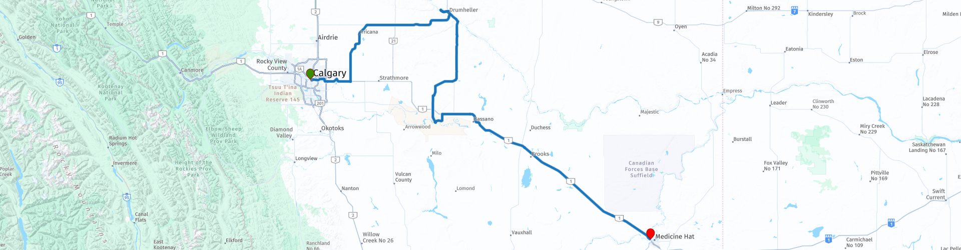
 This is section 7 which runs from Calgary to Medicine Hat.
The Trans-Canada Highway passes through all of the country's southern provinces. The route can be driven in various ways, as there are several alternative routes that also belong to the Trans-Canada Highway. The total distance is around 8,000 km. We won't be driving solely the Trans-Canada Highway, but will be taking as much of the country's back roads as possible, as highway driving alone is too boring, and Canada boasts many beautiful roads through its stunning landscape.
You'll drive through all the provinces and through very diverse and picturesque landscapes, from the Rockies in the west, the Central Prairies to the eastern Maritimes and the northern forest.
The riding season is generally from April to October with longer seasons on the west coast and southern Ontario.
Make sure you have good all-season clothing or bring rain gear. Depending on the province and the season, the weather can change suddenly and you might be surprised by a rain shower, or even a snow or hail shower, so be prepared.
In Canada, the metric system is used, so speeds are indicated in km/h. Helmets are mandatory throughout Canada (DOT approved).
Throughout Canada, you'll see plenty of wildlife. Similar animals vary from province to province, including deer, buffalo, moose, caribou, wolves, cougars, bears, mountain goats, sheep, lynx, coyotes, foxes, raccoons, badgers, various rodents, and a variety of birds.
Even though it is very tempting to stop for a photo, don't do it, it can be very dangerous.
I rate this route 4**** stars because of the beautiful sights at the beginning. The ride itself is rather dull, except for the AB-10X with its 11 bridges.
 Share this route


Animation

Verdict


Duration
9h 31m

Mode of travel
Car or motorcycle

Distance
469.53 km

Countries

 RouteXpert Review
 The Calgary skyline slowly fades from the rearview mirror as we start the engine for a long drive to Medicine Hat. Today, we have a stretch of almost 300 kilometers ahead of us, and let's be honest: most of this road is straight, flat, and not very exciting. But as always, the adventure lies in the details. And those details are especially evident at the beginning of this leg.
We'll start with a bit of city atmosphere. The imposing Calgary Tower rises 190 meters above downtown, an icon since 1968. A little further on lies Olympic Plaza, built for the 1988 Winter Games. The square is bustling with life, even now, decades later. On the right, historic City Hall gleams in the sun.
Just outside the city, the road glides past Chestermere Lake, a man-made reservoir once used for irrigation but now a haven for water sports enthusiasts. The water sparkles, surfers carve the waves, a final burst of dynamism before we enter the endless plains of the Palliser Triangle. Here, the land is dry, the roads are perfectly straight, and the horizon seems endless.
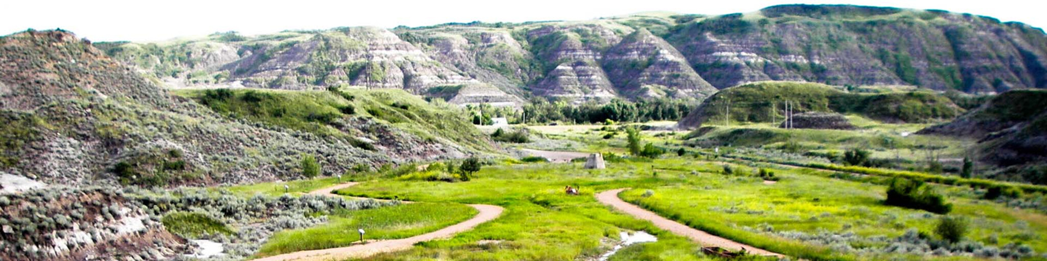
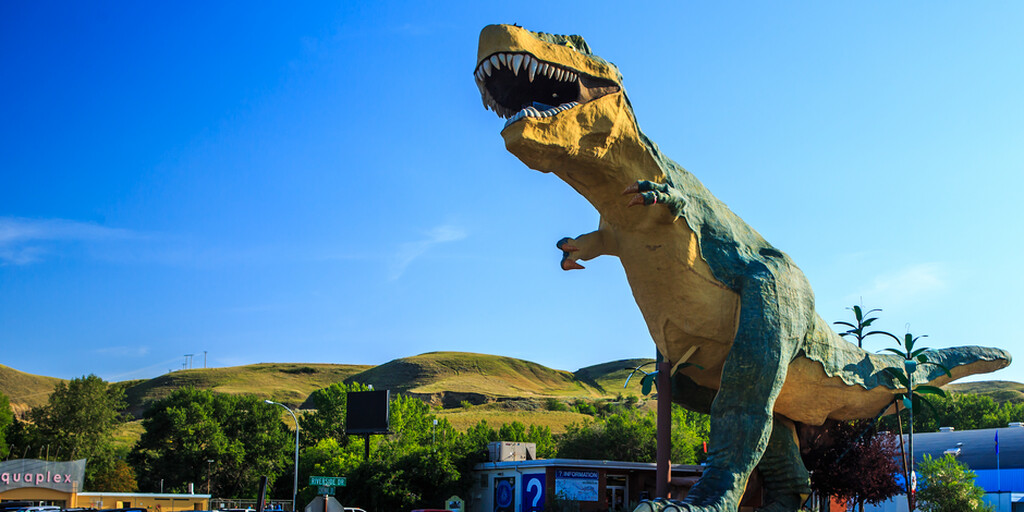
Towering high above the Drumheller Valley, Tyra, the world's largest dinosaur, offers a unique and breathtaking view of the badlands. Climb the 106 steps inside the dinosaur to experience the Drumheller Valley from Tyra's gaping mouth. At the foot of the dinosaur, you'll find official merchandise featuring "Tyra," the world's largest dinosaur, and a selection of locally produced items in our gift shop.
To add some color to the journey, we'll stop at a series of unique spots. Midland Provincial Park tells the story of Alberta's coal mining. We'll walk past old mining buildings and follow the Interpretive Trail, a step back in time.
A little further on, a world of prehistory awaits: the Royal Tyrrell Museum. Here, we'll come face to face with dinosaurs, fossils, and stories from millions of years ago. It's a place that sparks the imagination. For a touch of nostalgia, we visit the Homestead Antique Museum, where furniture, tools, and artifacts bring pioneer life to life.
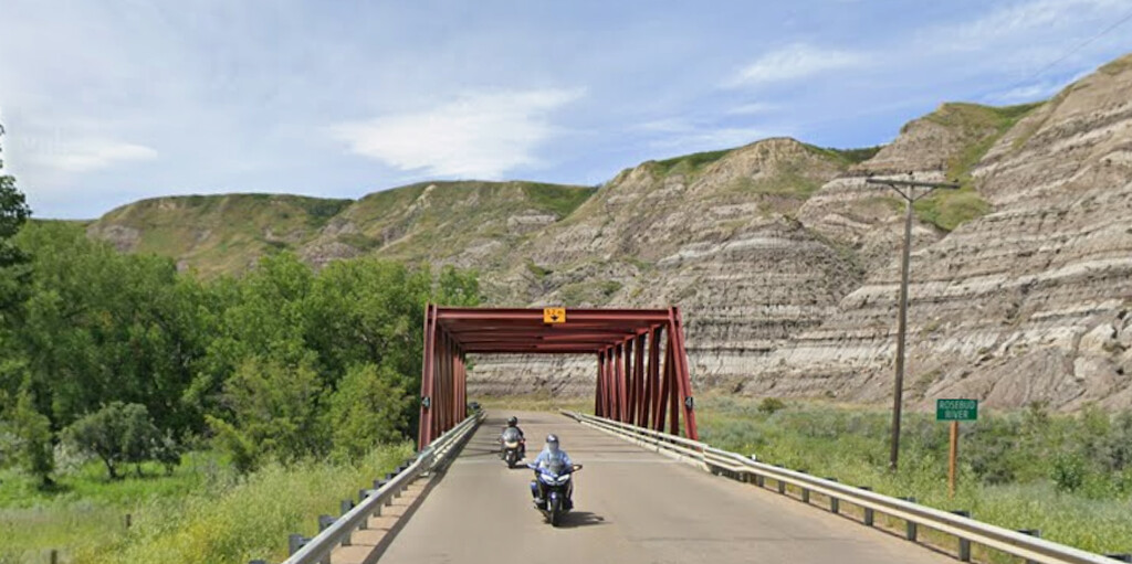
After a lunch stop in Drumheller, we drive along the AB-10X, which follows the course of the Rosebud River to Wayne. There are 11 old bridges that cross the river; stop frequently to enjoy the scenery and take photos. This is the most scenic part of the route.
At the Siksika 146 Indian Reserve in Alberta, we delve back into history at the Blackfoot Crossing Museum. Here, at the site where Treaty No. 7 was signed in 1877, we learn about the culture and traditions of the Siksika (Blackfoot) Nation. The museum is more than just a building; it's a deeply moving experience.
Then it's time to turn back onto the Trans-Canada Highway. Ahead of us lie another 170 kilometers of asphalt, straight and unforgiving. The prairie stretches to the horizon, beneath a sky that seems to end in eternity. It's a drive that gives your mind space, a moment to reflect on everything we've seen today.
When we reach Medicine Hat, the sun is low and golden. I give this stage three stars: not for the road itself, but for the stories, museums, and encounters that brightened the start of the day. Tomorrow awaits a new chapter, and hopefully more twists and turns.
 Links
Links  Usage
Usage Want to download this route?
You can download the route for free without MyRoute-app account. To do so, open the route and click 'save as'. Want to edit this route?
No problem, start by opening the route. Follow the tutorial and create your personal MyRoute-app account. After registration, your trial starts automatically.  Disclaimer
Use of this GPS route is at your own expense and risk. The route has been carefully composed and checked by a MyRoute-app accredited RouteXpert for use on TomTom, Garmin and MyRoute-app Navigation.
Changes may nevertheless have occurred due to changed circumstances, road diversions or seasonal closures. We therefore recommend checking each route before use.
Preferably use the route track in your navigation system. More information about the use of MyRoute-app can be found on the website under 'Community' or 'Academy'.