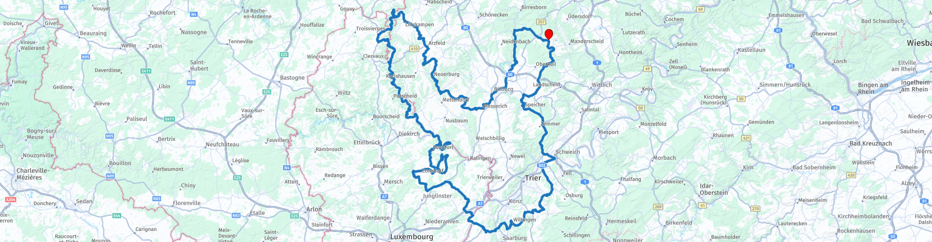
Roundtrip Deudesfeld Muellerthal Berdorf Vianden Bittburg Deudesfeld

This route was brought to you by:
RouteXpert René Plücken (MRA Master)
Last edit: 20-08-2025
 Route Summary
 I created and rode this route in 2014. Our base was a holiday home in Deudesfeld, near Daun, in the Volcanic Eifel.
This route goes through the Volcanic Eifel, Luxembourg and a small part through Belgium, with many beautiful winding roads. You pass several villages and towns where you can stop for a drink, something to eat or to see something.
Along the way you will see castles and other historical buildings, some of which are open to visitors.
It is a long route of about 375 kilometers, so if you want to visit sights and take part in guided tours of castles, you will have to shorten the route a bit, there are several options included in the route to shorten the route.
It is also possible to visit the Bitburg Beer Brewery.
I rate this route with 5 stars.
 Share this route


Animation

Verdict


Duration
9h 52m

Mode of travel
Car or motorcycle

Distance
372.64 km

Countries


 RouteXpert Review
 This route starts in Deudesfeld, a village in the German Eifel, but runs for a large part through Luxembourg and even a small part through Belgium. The total ride is 375 km, so you are on the road all day. Plan in advance which sights you want to visit, more information is included in the links in this review.
The winding roads of Luxembourg are a paradise for motorcyclists and popular destinations in the Luxembourg Ardennes include Beaufort, Vianden, Echternach, Berdorf and Larochette, several of which are also on the route. The countryside in Luxembourg is beautiful and there are many historical sights, such as castles and fortresses, so there is plenty to see along the way.
One of the most popular areas is the Mullerthal, which is characterized by large and often jagged rocks and fairytale forests with streams and waterfalls, the most beautiful is the Schiessentümpel waterfall, for which a POI and Route point are included in this route. The many hairpin bends and the beautiful nature between the rocks in the Mullerthal make the area a popular destination for motorcyclists, but also for cyclists, hikers and other tourists. So keep in mind that it can be very busy and be considerate of each other. Larrochette is a popular village, where motorcyclists like to plan a break, this is included as a lunch stop in the route.
Along the route there are a number of sights that you can visit, as described below.
The Aquatower in Berdorf is a 55-meter high water tower. In addition to an impressive view of Berdorf and the surrounding area, they offer an exhibition with various interactive consoles on the theme of "water and geology".
Beaufort Castle and Renaissance Palace where you can experience the history of Luxembourg from the Middle Ages to the present. Explore the medieval castle, built and expanded in four periods between 1015 and 1650, features different architectural styles such as Romanesque, Gothic and Renaissance. The more than 350 year old palace with four wings in French Renaissance style.
Vianden is a lovely town in the Grand Duchy of Luxembourg. The imposing medieval castle on top of the hill makes it look like a fairytale. With only 2,000 inhabitants and its picturesque houses, Vianden does not feel like a town at all, but more like a cozy village. Definitely worth a visit.
When leaving Vianden you drive past the dam in Vianden, which has been transformed into a gigantic work of art. The German artist Klaus Dauven creates, with the help of the company Kärcher (manufacturer of high-pressure cleaners), a "Reverse Graffiti" artwork. The artwork shows the faces of five workers who were involved in the construction of the structure.
Towards the end of the tour we drive through Bitburg, where you will find the Bitburg Brewery and its visitor centre. For over 200 years, one of the most famous German beers has been brewed here. The Bitburger Experience offers visitors an insight into the family brewery, its success story and the entire world of beer brewing. See, hear, smell and taste what makes Bitburger Premium Pils so special during a guided tour. At the historic brewery location, you can experience the fascinating world of beer on 1,700 square metres: the tour leads through our historic brewhouse with its gleaming copper vats and ends in the old boiler house with its extra-high ceilings, where you can taste the beers in the Bit-Lounge.
From Bitburg it is about a 45-minute drive to the holiday home.


 Links
Links  Usage
Usage Want to download this route?
You can download the route for free without MyRoute-app account. To do so, open the route and click 'save as'. Want to edit this route?
No problem, start by opening the route. Follow the tutorial and create your personal MyRoute-app account. After registration, your trial starts automatically.  Disclaimer
Use of this GPS route is at your own expense and risk. The route has been carefully composed and checked by a MyRoute-app accredited RouteXpert for use on TomTom, Garmin and MyRoute-app Navigation.
Changes may nevertheless have occurred due to changed circumstances, road diversions or seasonal closures. We therefore recommend checking each route before use.
Preferably use the route track in your navigation system. More information about the use of MyRoute-app can be found on the website under 'Community' or 'Academy'.

Rheinland Pfalz
About this region
Rhineland-Palatinate (German: Rheinland-Pfalz, [ˈʁaɪ̯nlant ˈp͡falt͡s] (listen)) is a western state of Germany. It covers 19,846 km2 (7,663 sq mi) and has about 4.05 million residents. It is the ninth largest and sixth most populous of the sixteen states. Mainz is the capital and largest city. Other cities are Ludwigshafen am Rhein, Koblenz, Trier, Kaiserslautern and Worms. It is bordered by North Rhine-Westphalia, Saarland, Baden-Württemberg and Hesse and by the countries France, Luxembourg and Belgium.
Rhineland-Palatinate was established in 1946 after World War II, from parts of the former states of Prussia (part of its Rhineland province), Hesse and Bavaria (its former outlying Palatinate kreis or district), by the French military administration in Allied-occupied Germany. Rhineland-Palatinate became part of the Federal Republic of Germany in 1949 and shared the country's only border with the Saar Protectorate until the latter was returned to German control in 1957. Rhineland-Palatinate's natural and cultural heritage includes the extensive Palatinate winegrowing region, picturesque landscapes, and many castles and palaces.
Read more on Wikipedia
Rhineland-Palatinate was established in 1946 after World War II, from parts of the former states of Prussia (part of its Rhineland province), Hesse and Bavaria (its former outlying Palatinate kreis or district), by the French military administration in Allied-occupied Germany. Rhineland-Palatinate became part of the Federal Republic of Germany in 1949 and shared the country's only border with the Saar Protectorate until the latter was returned to German control in 1957. Rhineland-Palatinate's natural and cultural heritage includes the extensive Palatinate winegrowing region, picturesque landscapes, and many castles and palaces.
View region
 Statistics
  140
140Amount of RX reviews (Rheinland Pfalz)
 48077
48077Amount of visitors (Rheinland Pfalz)
 27841
27841Amount of downloads (Rheinland Pfalz)
 Route Collections in this region
 Top 5 Car and Motorcycle Routes in the Eifel
The Eifel is the eastern part of the medium plateau Eifel-Ardennes. It is located north of the Moselle and west of the Rhine. The largest part is in Germany, a small part is in Belgium, in the East Cantons. The German part of Eifel is located in the federal states of North Rhine-Westphalia and Rhineland-Palatinate. The highest point is the Hohe Acht with 747 meters.
Several chains can be distinguished in the Eifel:
The northernmost part is called the Nordeifel, which in Belgium connects to the High Fens;
To the east of this is the Ahrgebirge, this part is located north of the Ahr in the Ahrweiler district;
South of the Ahr is the Hohe Eifel (or Hocheifel), of which the Hohe Acht (747 m) is the highest point, and also the highest point in the entire Eifel region;
To the west, near the Belgian border, the hills are known as Schneifel, part of the wider Snow Eifel area with peaks reaching up to 698 metres;
South and east of the Hohe Eifel is the Volcano-Eifel, a volcanic area with many crater lakes (Maare).
The southern part of the Eifel is less high. The area is bisected by streams and rivers running southwards. These streams flow into the Moselle. The largest of these rivers is the Kyll; the hills around this river are known as the Kyllwald;
In the south, the Eifel ends in the Voreifel.
In the north of the Eifel there are some large reservoirs. The largest of these is the reservoir in the Roer that was created by the construction of the Roerdal dam.
The Nürburgring is also located in the Eifel, a well-known car circuit for Formula 1 races, among other things. Since 2004, part of the north of the Eifel has become the Eifel National Park. This National Park falls entirely within the German-Belgian nature park High Fens-Eifel. Another part of the Eifel falls within the South Eifel Nature Park.
Well-known throughout the Netherlands and Belgium by car and motorcyclists, so reason enough for the MyRoute app RouteXpert to compile a Top 5 of Car and Motorbike routes for you.
All routes in this collection have been checked and made equal for TomTom, Garmin and MyRoute-app Navigation by a MyRoute-app RouteXpert.
If you think, I have a very nice route that should certainly not be missing from this collection, send it to:
email: routeexpert@myrouteapp.com
Subject: New Route for the Top 5 collection Eifel composed by Hans van de Ven.
The route will then be reviewed and then added to the Top 5. To make the Top 5 also the Top 5, 1 route will have to disappear from the Top 5, you can indicate this when submitting the new route.
Have fun with this collection and while driving one of these routes. Enjoy all the beauty that the Eifel has to offer. Click on “View route” to read the review of the chosen route.
I would like to hear your findings about the route(s).
View Route Collection
Route collection hairpins in the Eifel
This collection is composed of the most beautiful and winding roads in the Eifel. Forget Bundesstraßen, forget the road along the Moselle, if you have driven these roads, you can really say that you have been to the Eifel.
No less than 6 routes and 1,800 kilometers are waiting for you!
No less than 6 routes and 1,800 kilometers are waiting for you!
View Route Collection