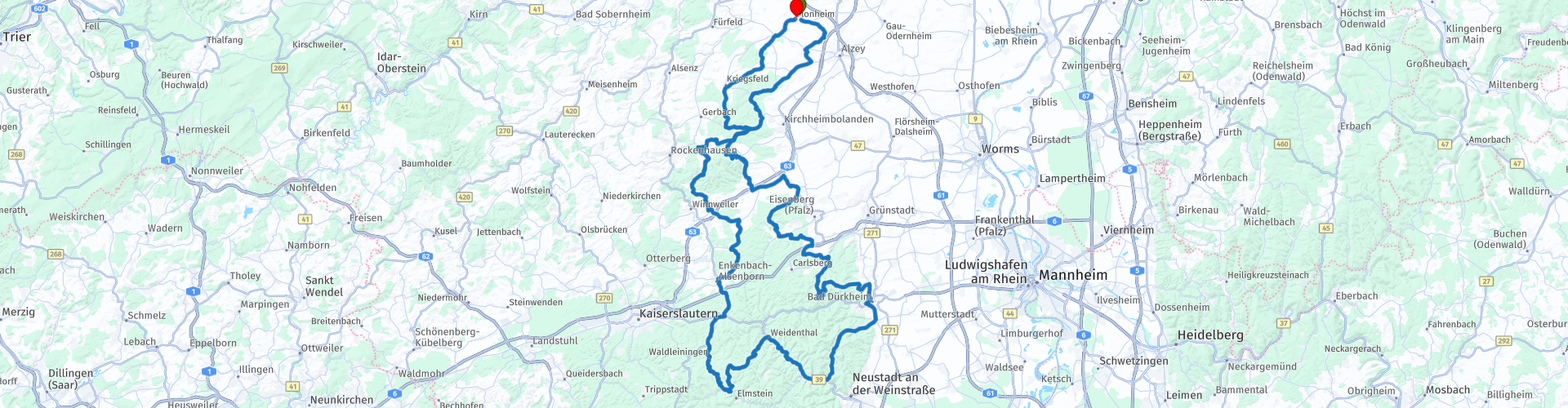
02 Rondrit Pfalzerwald via Donnersberg en Burgruine Falkenstein

This route was brought to you by:
RouteXpert Leonor Orban - Sr. RouteXpert
Last edit: 07-12-2024
 Route Summary
 If the points system would allow 6 stars, this route would definitely get them. It is a wonderful old-fashioned “driving day”. Many large and small bends, wonderfully smooth asphalt, good restaurants along the way with nice terraces... Now all we need is nice weather to enjoy it to the fullest!
 Share this route


Animation

Verdict


Duration
7h 52m

Mode of travel
Car or motorcycle

Distance
209.37 km

Countries

 RouteXpert Review
 From Flonheim you head south, with the early morning sun slowly rising above the landscape. The first special place on the route is the gate of the former Augustinian abbey Kloster Höningen. This historic monastery site, founded in the 12th century, was once a cultural centre and has a turbulent history of prosperity and decline. The gate you drive through is still a reminder of this past.
Your motorbike continues to glide over the smooth asphalt of the winding roads through the forest, with the scent of pine trees as a constant companion. After more than two hours of riding, it is time for a well-deserved break at Lindemannsruhe. This restaurant, hidden between the trees, offers a nice place to recover. Park the motorbike on the left side of the road, cross the road and enjoy a cup of coffee or a hearty lunch in the open air.
After the break, the tour continues and takes you through Bad Dürkheim, where an optional stop at the Dürkheimer Riesenfass is possible. This immense wine barrel, which serves as a restaurant, is a sight in itself with its 13.5-metre diameter. For those who fancy a short break, this is a great opportunity to look around or have a drink.
Further along the route, the Wachtenburg looms on the left. This 12th-century castle ruin towers above the landscape and offers breathtaking views of the Rhine Valley. Although the ride continues, it is impressive to be able to view this medieval fortress from the road.
About an hour and a half after the first break, it is time to get off again, this time at Forsthaus Silbertal. This forest restaurant, right in the heart of the Palatinate Forest, is an ideal place to have a drink and enjoy the peace that the surrounding forest offers.
After the break, the engines are started again and the route continues through the green. After about 140 kilometers there is a possibility to refuel, if the engine has become thirsty from all the hilly roads and sharp bends.
Not much later you will pass the Falkensteiner Schlucht, an impressive gorge where a short photo stop is definitely worthwhile. Park on the right and capture the spectacular view of the road along the dripping rock face. After this it is time to focus fully on the road again, because a steep and narrow road lies ahead. This part of the route requires your full attention and at the same time offers one of the most challenging parts of the ride.
Almost at the end of the climb, Burg Falkenstein awaits you, a medieval castle with a rich history. Among other things, the Sachsenspiegel, the first German law book, was written here. The castle now houses a museum and a falconry. If you take the time to look around, you can immerse yourself in history or enjoy a bite to eat and a drink in the restaurant next to the castle. For those who prefer to drive a bit further, Restaurant Falkensteiner Hof is located a little further along the route. This restaurant has a terrace with a beautiful view of the castle and the valley.
After the last optional stop, it is another 40 kilometres back to Flonheim. The sun is slowly starting to set, while the motorbikes make their last kilometres on the German roads. Back at Hotel Dohlmühle, a relaxing end to the day awaits: a good glass of wine from the local winegrower on the terrace. A perfect moment to talk about the beautiful route and the special places that passed by today. Tomorrow, the return journey to the Netherlands awaits, but tonight it is time to enjoy good food and delicious wine.


 Links
Links  Usage
Usage Want to download this route?
You can download the route for free without MyRoute-app account. To do so, open the route and click 'save as'. Want to edit this route?
No problem, start by opening the route. Follow the tutorial and create your personal MyRoute-app account. After registration, your trial starts automatically.  Disclaimer
Use of this GPS route is at your own expense and risk. The route has been carefully composed and checked by a MyRoute-app accredited RouteXpert for use on TomTom, Garmin and MyRoute-app Navigation.
Changes may nevertheless have occurred due to changed circumstances, road diversions or seasonal closures. We therefore recommend checking each route before use.
Preferably use the route track in your navigation system. More information about the use of MyRoute-app can be found on the website under 'Community' or 'Academy'.

Rheinland Pfalz
About this region
Rhineland-Palatinate (German: Rheinland-Pfalz, [ˈʁaɪ̯nlant ˈp͡falt͡s] (listen)) is a western state of Germany. It covers 19,846 km2 (7,663 sq mi) and has about 4.05 million residents. It is the ninth largest and sixth most populous of the sixteen states. Mainz is the capital and largest city. Other cities are Ludwigshafen am Rhein, Koblenz, Trier, Kaiserslautern and Worms. It is bordered by North Rhine-Westphalia, Saarland, Baden-Württemberg and Hesse and by the countries France, Luxembourg and Belgium.
Rhineland-Palatinate was established in 1946 after World War II, from parts of the former states of Prussia (part of its Rhineland province), Hesse and Bavaria (its former outlying Palatinate kreis or district), by the French military administration in Allied-occupied Germany. Rhineland-Palatinate became part of the Federal Republic of Germany in 1949 and shared the country's only border with the Saar Protectorate until the latter was returned to German control in 1957. Rhineland-Palatinate's natural and cultural heritage includes the extensive Palatinate winegrowing region, picturesque landscapes, and many castles and palaces.
Read more on Wikipedia
Rhineland-Palatinate was established in 1946 after World War II, from parts of the former states of Prussia (part of its Rhineland province), Hesse and Bavaria (its former outlying Palatinate kreis or district), by the French military administration in Allied-occupied Germany. Rhineland-Palatinate became part of the Federal Republic of Germany in 1949 and shared the country's only border with the Saar Protectorate until the latter was returned to German control in 1957. Rhineland-Palatinate's natural and cultural heritage includes the extensive Palatinate winegrowing region, picturesque landscapes, and many castles and palaces.
View region
 Statistics
  140
140Amount of RX reviews (Rheinland Pfalz)
 48078
48078Amount of visitors (Rheinland Pfalz)
 27841
27841Amount of downloads (Rheinland Pfalz)
 Route Collections in this region
 Top 5 Car and Motorcycle Routes in the Eifel
The Eifel is the eastern part of the medium plateau Eifel-Ardennes. It is located north of the Moselle and west of the Rhine. The largest part is in Germany, a small part is in Belgium, in the East Cantons. The German part of Eifel is located in the federal states of North Rhine-Westphalia and Rhineland-Palatinate. The highest point is the Hohe Acht with 747 meters.
Several chains can be distinguished in the Eifel:
The northernmost part is called the Nordeifel, which in Belgium connects to the High Fens;
To the east of this is the Ahrgebirge, this part is located north of the Ahr in the Ahrweiler district;
South of the Ahr is the Hohe Eifel (or Hocheifel), of which the Hohe Acht (747 m) is the highest point, and also the highest point in the entire Eifel region;
To the west, near the Belgian border, the hills are known as Schneifel, part of the wider Snow Eifel area with peaks reaching up to 698 metres;
South and east of the Hohe Eifel is the Volcano-Eifel, a volcanic area with many crater lakes (Maare).
The southern part of the Eifel is less high. The area is bisected by streams and rivers running southwards. These streams flow into the Moselle. The largest of these rivers is the Kyll; the hills around this river are known as the Kyllwald;
In the south, the Eifel ends in the Voreifel.
In the north of the Eifel there are some large reservoirs. The largest of these is the reservoir in the Roer that was created by the construction of the Roerdal dam.
The Nürburgring is also located in the Eifel, a well-known car circuit for Formula 1 races, among other things. Since 2004, part of the north of the Eifel has become the Eifel National Park. This National Park falls entirely within the German-Belgian nature park High Fens-Eifel. Another part of the Eifel falls within the South Eifel Nature Park.
Well-known throughout the Netherlands and Belgium by car and motorcyclists, so reason enough for the MyRoute app RouteXpert to compile a Top 5 of Car and Motorbike routes for you.
All routes in this collection have been checked and made equal for TomTom, Garmin and MyRoute-app Navigation by a MyRoute-app RouteXpert.
If you think, I have a very nice route that should certainly not be missing from this collection, send it to:
email: routeexpert@myrouteapp.com
Subject: New Route for the Top 5 collection Eifel composed by Hans van de Ven.
The route will then be reviewed and then added to the Top 5. To make the Top 5 also the Top 5, 1 route will have to disappear from the Top 5, you can indicate this when submitting the new route.
Have fun with this collection and while driving one of these routes. Enjoy all the beauty that the Eifel has to offer. Click on “View route” to read the review of the chosen route.
I would like to hear your findings about the route(s).
View Route Collection
Route collection hairpins in the Eifel
This collection is composed of the most beautiful and winding roads in the Eifel. Forget Bundesstraßen, forget the road along the Moselle, if you have driven these roads, you can really say that you have been to the Eifel.
No less than 6 routes and 1,800 kilometers are waiting for you!
No less than 6 routes and 1,800 kilometers are waiting for you!
View Route Collection