Biarritz to Isaba

This route was brought to you by:
RouteXpert Jannes van Dijken
Last edit: 14-04-2024
 Route Summary
 From the charming seaside resort of Biarritz in the French part of the Basque Country, the route goes via the westernmost spur of the Pyrenees deep into the Spanish part of the Basque Country to the small and quiet village of Isaba in the mountains. The transition from hustle and bustle on the coast to total tranquility in the mountains is breathtaking and unforgettable. From wide good roads to narrow mountain roads, this route has them all.
I gave this route 4 stars because the roads are generally good, the landscape and views sometimes take your breath away and the nature and total tranquility are really impressive.
 Share this route


Animation

Verdict


Duration
8h 44m

Mode of travel
Car or motorcycle

Distance
256.75 km

Countries


 RouteXpert Review
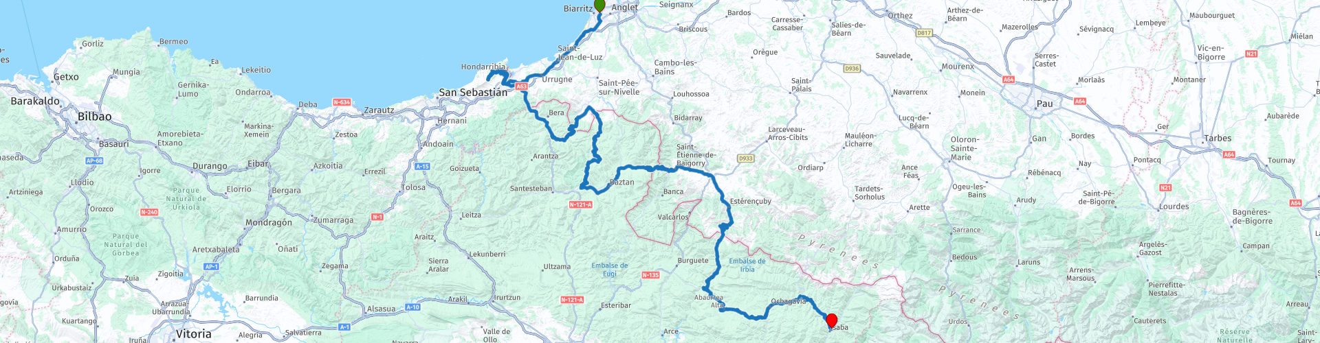
 The fashionable Biarritz in France, also seen as a surfers' paradise, is the starting point of the route. The route goes along the coast towards Saint-Jean-de-Luz. This picturesque coastal town has everything you expect from a French coastal town. 15km further on you cross the border for the first time today. Hondarribia, is the first Basque town on this side of the border. It is a charming town with colorful houses, narrow streets and a medieval castle. Just outside the city is the Jaizkibel, in cycling the Jaizkibel is included every year in the Clásica San Sebastián. So you can meet many cyclists here. You must pass this at a minimum distance of 1.5 meters. At the highest point there is a beautiful viewpoint with a view of the coast and the ocean. After the descent back to Hondarribia it is time for coffee. Panaderia Ondare is a beloved bakery of the locals. Highly recommended.
Continuing the route you follow the Bidasoa river for a while before leaving the main road and heading into the mountains. 15 kilometers further you have already conquered the first mountain of the day. You are now back in France. Here the roads are narrow, mind your speed. Another 15 kilometers further you drive back into Spain. The roads are narrow again and the quality is not always the best. Watch out for stray cattle!
Descending gently you arrive back in a more inhabited area. That's a good thing because it's time for lunch. In Elizondo, Restaurant–Bar Juli is a hidden gem. A small restaurant with an enthusiastic owner and delicious dishes.
After lunch the route climbs again. The border is again at the next mountain pass. This is a viewpoint with a view over the valley that runs deep into France. The way down will also have several points where you may want to stop for a photo. When the route bends south again, the road goes up again. The last border crossing of today is coming up. Here you will find the megalithic (sanctuary or funerary monument) complex of Cromlech de Organbide. One of many in the area. The road slowly brings you back to civilization. For a while then, because after Aribe, where there is still a small supermarket and a gas station, towns become smaller again and the roads are quieter again. The route continues for another 50 kilometers through wooded areas before you reach the end of the route.
Isaba is at the end of the route. This picturesque little village is the stopping place for active sports enthusiasts in both winter and summer. The hotels and restaurants in the village are small-scale and clearly not aimed at mass tourism.


 Links
Links  Usage
Usage Want to download this route?
You can download the route for free without MyRoute-app account. To do so, open the route and click 'save as'. Want to edit this route?
No problem, start by opening the route. Follow the tutorial and create your personal MyRoute-app account. After registration, your trial starts automatically.  Disclaimer
Use of this GPS route is at your own expense and risk. The route has been carefully composed and checked by a MyRoute-app accredited RouteXpert for use on TomTom, Garmin and MyRoute-app Navigation.
Changes may nevertheless have occurred due to changed circumstances, road diversions or seasonal closures. We therefore recommend checking each route before use.
Preferably use the route track in your navigation system. More information about the use of MyRoute-app can be found on the website under 'Community' or 'Academy'.

Navarre
About this region
Navarre (English: ; Spanish: Navarra [naˈβara]; Basque: Nafarroa [nafaro.a]), officially the Chartered Community of Navarre (Spanish: Comunidad Foral de Navarra [komuniˈðað foˈɾal de naˈβara]; Basque: Nafarroako Foru Komunitatea [nafaro.ako foɾu komunitate.a]), is an autonomous community and province in northern Spain, bordering the Basque Autonomous Community, La Rioja, and Aragon in Spain and Nouvelle-Aquitaine in France. The capital city is Pamplona (or Iruñea in Basque). The present-day province makes up the majority of the territory of the medieval Kingdom of Navarre, a long-standing Pyrenean kingdom that occupied lands on both sides of the western Pyrenees, with its northernmost part, Lower Navarre, located in the southwest corner of France.
Navarre is in the transition zone between Green Spain and semi-arid interior areas, and thus its landscapes vary widely across the region. Being in a transition zone also produces a highly variable climate, with summers that are a mix of cooler spells and heat waves, and winters that are mild fir the latitude. Navarre is one of the historic Basque districts: its Basque features are conspicuous in the north, but virtually absent on the southern fringes. The best-known event in Navarre is the annual San Fermín festival held in Pamplona in July.
Read more on Wikipedia
Navarre is in the transition zone between Green Spain and semi-arid interior areas, and thus its landscapes vary widely across the region. Being in a transition zone also produces a highly variable climate, with summers that are a mix of cooler spells and heat waves, and winters that are mild fir the latitude. Navarre is one of the historic Basque districts: its Basque features are conspicuous in the north, but virtually absent on the southern fringes. The best-known event in Navarre is the annual San Fermín festival held in Pamplona in July.
View region
 Statistics
  9
9Amount of RX reviews (Navarre)
 26452
26452Amount of visitors (Navarre)
 391
391Amount of downloads (Navarre)
 Route Collections in this region
 Pyrenees from West to East
The Spanish Pyrenees are a majestic mountain region in the north of Spain, stretching along the border with France. This enchanting landscape offers a rich mix of natural beauty, historic towns and adventure opportunities.
This collection of 4 routes makes a complete route from Biarritz over the northernmost paved roads in the Spanish Pyrenees, with small side trips into France, to Cap de Creus. The viewpoint on Monte Jaizkibel, the westernmost point, where you have a view of the Bay of Biscay, is the starting point of this trip. The routes are divided into day routes. So a route every day.
The end point is Cap de Creus, the easternmost point of mainland Spain. The last route offers space to drive to your overnight stay in peace and quiet after the last route point.
Use the collection as you wish. Drive from West to East or use the individual routes as an idea for your own Pyrenees adventure.
View Route Collection
Santander to Roscoff via Picos de Europa Pyrenees West coast of France
A tour with 9 routes that all link up, starting from the ferry port of Santander to Potes using lots of twisty roads. The next route is a truly memorable round tour from Potes of the ever popular Picos de Europa. Then the tour heads south and east past reservoirs and picking up the mighty Ebro river and follow it to Miranda de Ebro. Route 4 carries on east towards the Pyrenees with more twisty roads to the destination of Sos del Rey Catolico, a fantastic fortified hilltop village. The next route takes you over the Pyrenees with the chance of a cable car ride up a mountain for lunch. Route 6 is the first day in France and it is a pleasant ride past fields of sunflowers and maize, pine forests and through the Landes de Gascogne Regional Natural Park. Then you cross over the mighty Gironde estuary by ferry and head to the finish at the popular costal town of La Rochelle. We stayed for two night in La Rochelle to sample the delights of this delightful town. Route 7 hugs the coast as it travels north and then crosses the mighty Loire river for a night in Saint Nazaire. Route 8 starts off with a visit to the U boat submarine pens in Saint Nazaire, then through the salt production 'fields' of Guerande and onto Concarneau, another historic walled city that must be visited. The final route takes you to Pointe du Raz then onto Locronan, a medieval village listed as one of the most beautiful villages of France. Then it travels over the Térénez bridge, the world's first curved cable-stayed bridge. Then you enter and travel through the Armorique Regional Natural Park to spend the night at a B&B hotel in Morlaix ready for a short ride in the morning to catch the ferry at Roscoff.
View Route Collection