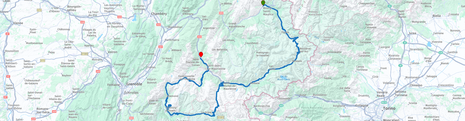
R04 - Bourg St Maurice to St Etienne de Cuines

This route was brought to you by:
RouteXpert Arno van Lochem - Senior RX
Last edit: 01-02-2021
 Route Summary
 The route starts in Bourg-Saint-Maurice at the hotel Relais de la Venoise. A number of beautiful cols are conquered today, including the Col de l'Iseran, Col de la Madeleine, Col du Télégraphe and the Galibier. The route also passes several large lakes.
The route ends in Saint-Etienne-de-Cuines at Ibis Budget hotel Saint-Jean-de-Maurienne.
The route is for the more advanced motorcyclist given the occasional tight hairpin bends in the Alps. Good engine management is desired!
 Share this route


Animation

Verdict


Duration
6h 30m

Mode of travel
Car or motorcycle

Distance
307.45 km

Countries

 RouteXpert Review
 The route starts at Hotel Relais de la Venoise, a small but cozy typical French hotel in Bourg-Saint-Maurice, a small town along the Isère. The Isère is a river of 290 kilometers that originates from the Col de l'Iseran. Winding along this river you leave the D902 just before Lac du Chevril. Via a smaller road, the D87B, you drive after a few kilometers over the 'Barrage du Chevril'.
This Chevril dam is also called Tignes dam because this dam (under much protest) flooded Tignes. The protest was to no avail and construction started in 1948. The dam was completed in 1952. After the 'drowning' of the place Tignes, this city was rebuilt at a different location.
The dam, with a height of 181 meters, was once the highest arch dam in Europe. That is now outdated, but it is still the highest arch dam in France.
Shortly after the Chevril dam you enter Val d'Isère, a village situated at an altitude of 1850 meters. Quite quiet in the summer, in the winter a busy winter sports resort. Unlike many other French ski resorts, Val d'Isère tries to preserve the character and appearance of a French mountain village. The buildings in and around the center have the architectural style of authentic chalets and farms. This is due to a maximum building height. The large concrete complexes often built in other French resorts are missing from the center. That enhances the appearance of the village, it sometimes seems as if time has stood still here and it certainly improves the atmosphere.
After leaving Val d'Isère it is time for the first col of today, the Col de l'Iseran, The Col de l'Iseran with its 2770m is one of the highest paved mountain passes in the Alps. Along the way, hairpin bends, of course, but also many beautiful views. In fact, you would like to stop at every turn to take a picture, always a great view. At RP5 you have a fantastic view over the valley in which Val d'Isère lies.
The route winds further up until you have reached the highest point of 2770 meters. Worth stopping for a moment and enjoying the great view.
The descent on the other side winds through the side valley of the Maurienne, very green in summer, which lies entirely in the Parc National de la Vanoise. With a bit of luck you can spot marmots or perhaps a chamois here. While descending, you can enjoy the great piece of nature you drive through again. Take the time for a photo every now and then!
During the descent you actually drive unnoticed over the Col de Madeleine, a mountain with a pass height of 1746 meters. Only a small sign on the side gives away the name of the Col. And that while the mountain is a very well-known col in the Tour de France. The col has already been included in this cycling tour of France 25 times, the first time in 1952, the last time in 2018.
The route runs for a while on the D902, which turns into the D1006 at Lanslebourg-Mont-Cenis. You keep driving along a river, the Arc. The Arc is a tributary of the Isère in the Maurienne Valley. This valley runs from the source of the river Arc, on the south side of the Col de l'Iséran, to Albertville, where the Arc flows into the Isère. The valley is of great economic importance because of the motorway to Italy.
In Sollières-Sardières, the route takes a detour to the D83, a beautifully winding road through the Maurienne Valley. This road has some climbs, which in turn guarantees beautiful views. In Aussois the D83 changes into the D215, which you keep following until Modane. After a roundabout the road is number D1006 again. Do you still understand? Actually, the road number does not matter, after all, it is about the beautiful environment you drive in!
Arriving in Saint-Michel-de-Maurienne, turn left onto the D902, towards the Col du Télégraphe, with a pass height of 1566 meters. This col is also well known in the Tour de France, the col is often included in the round. The combination with the Galibier, which is on the route after the Col du Télégraphe, is a favorite, a real calf-biter. Fortunately, the engine has less trouble with it.
As mentioned, the D902 also runs over the Galibier with a pass height of 2642 meters. Really a great climb, although you have to watch out for the many cyclists. Once at the top, the first thing you notice is the crowds in the parking lot. Lots of tourists, but also a lot of people waiting for their cycling companion.
From the top a footpath leads to a viewpoint at 2704 meters. The view from this high point is formidable in all directions. Clear weather is necessary, of course, in the fog you can actually save yourself this climb.
In the descent of this imposing mountain you also pass the Col du Lautaret with a height of 2058 meters. The Jardin Botanique Alpin is located on this col, after another short climb to 2100 meters. This botanical garden, also called Jardin d'Altitude des Cinq Continents, is part of the Alpine Joseph Fourier Station. In this garden, created in 1899, plants from the Alps, the Caucasus, the Andes, the Himalayas and the polar regions are grown.
After this botanical splendor, follow the route on the D1091, which takes you past Lac du Chambon, among other things. A small river, the Romanche, also runs along the D1091. The Romanche is a 78 km long river that has its source in the Pelvoux massif. The Romanche flows into the Lac de Chambon, but on the other side of the lake this river continues its way.
Just after the Lac du Chambon you leave the D1091 in the place Le Freney-d'Oisans and follow the D211A. It is obvious to keep following the D1091 to Alp d'Huez, but just pay attention to what a beautiful view this D211A will offer you. You shouldn't have a fear of heights by the way ....
The D211A with its old viaducts leads to the D211, which takes you towards Alp d'Huez. Of course 'world famous' from the Tour de France. The climb to this place is often included in one of the stages, where the finish is usually in the village. Once arrived in Alp d'Huez, the route goes up through the village, it is striking that in the summer (except for the stage of the Tour de France) there is not much to do in the village. It is truly a winter sports resort. When you drive out of the village, turn off to the D211B. On this D211B you will soon drive over the Pas de la Confession, a pass with a height of 1542 meters. From this 'pass' you have a beautiful view of the surrounding mountains.
The D211B turns into the D44B, which takes you towards Lac de Verney. This is a reservoir where swimming is not allowed, but various water sports such as canoeing and pedal boating can be practiced.
After the Lac du Verney you continue the route on the D526, a beautiful road through a truly beautiful area. Nice long turners alternate with shorter turns, making it great to steer on this road. After enjoying this road for about 16 kilometers, you will arrive at the Lac du Grand Maison reservoir. The lake was created by the construction of the Grand Maison dam which was completed in 1985.
Shortly after the Lac du Grand Maison, the D526 changes into the D926. The road number may be different, but the number of great curves is no different from the D526. While turning these wonderful curves you will pass today's last col, the Col de la Croix de Fer at an altitude of 2067 meters. This mountain pass serves as a passage between the departments of Savoie and Isère in summer, but is closed in winter due to the many snow that falls there. Of course you can often ski on this mountain.
In the descent of the Col de la Croix de Fer you are treated to a few beautiful hairpin bends. For now you follow the D926 where you still encounter bend after bend. In Saint-Jean-de-Marienne, the fun is over and you are (again) on the D1006. This takes you, again parallel to the river Arc, towards Saint-Etienne-de-Cuines. However, just before the end you can beautifully see the first few very tight hairpin bends of the Col du Chaussy at RP30, as if these bends are glued to the mountain wall. Great to see.
Shortly afterwards you turn off and drive the last kilometers to hotel B&B Hotel Saint-Jean-de-Maurienne, today's end point. If you want to fill up the engine for a while, you can find two petrol stations near the hotel, one of which can be seen from the hotel parking lot, the other is 100m away.
If you want a bite to eat and a drink in the evening, you can go to restaurant and bar l'Inter. Simple set up, but the food and beer taste good after a hard day's work on all those cols!
Have fun driving this route!


 Links
Links  Usage
Usage Want to download this route?
You can download the route for free without MyRoute-app account. To do so, open the route and click 'save as'. Want to edit this route?
No problem, start by opening the route. Follow the tutorial and create your personal MyRoute-app account. After registration, your trial starts automatically.  Disclaimer
Use of this GPS route is at your own expense and risk. The route has been carefully composed and checked by a MyRoute-app accredited RouteXpert for use on TomTom, Garmin and MyRoute-app Navigation.
Changes may nevertheless have occurred due to changed circumstances, road diversions or seasonal closures. We therefore recommend checking each route before use.
Preferably use the route track in your navigation system. More information about the use of MyRoute-app can be found on the website under 'Community' or 'Academy'.