R01 - Girona to Sant Julia de Loria

This route was brought to you by:
RouteXpert Arno van Lochem - Senior RX
Last edit: 27-07-2021
 Route Summary
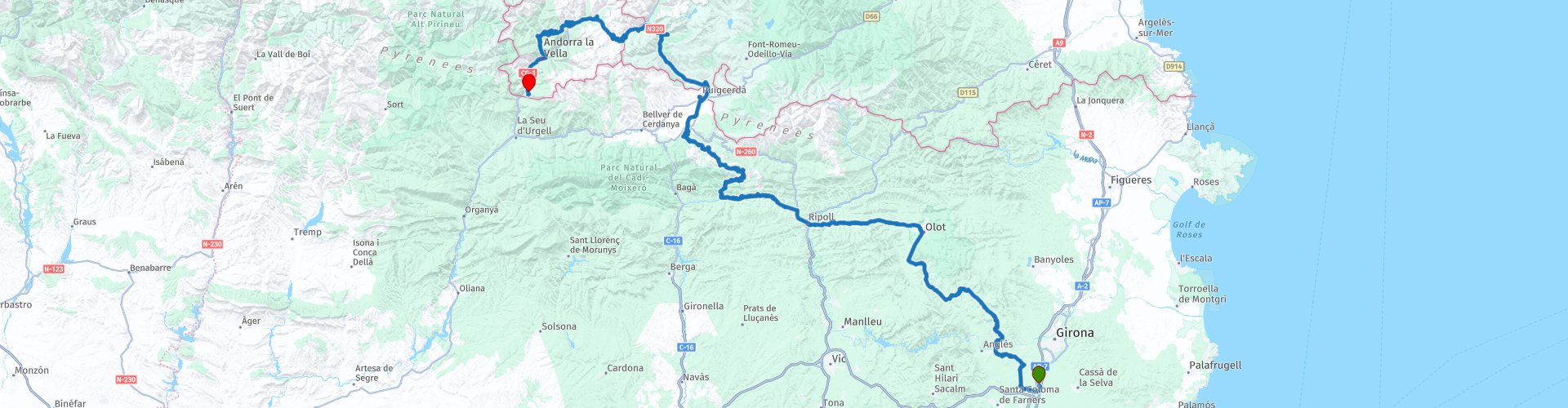
 Barcelona, the capital of Catalonia, is known as a beautiful city. But the hinterland of Catalonia is also to die for. And that's where this route starts: Close to Girona airport.
You set course through the 'Natural Park of the Volcanic Area of the Garrotxa' and the 'Regional Natural Park of the Catalan Pyrenees' towards Andora. The route ends there, in Sant Julià de Lòria at the Hotel Coma Bella.
This route is part of a tour through Catalonia, Andorra and the Pyrenees. This tour is divided into seven routes, of which this is the first part.
The route is for the more advanced motorcyclist. Especially the last part requires good engine management given the (tight!) Hairpin bends.
 Share this route


Animation

Verdict


Duration
8h 26m

Mode of travel
Car or motorcycle

Distance
269.13 km

Countries


 RouteXpert Review
 Given the beautiful environment in which the roads are really formidable and provide a lot of driving pleasure, I rate this route with 5 stars.
If you do not have access to your own motorcycle, you can rent a motorcycle. A motorcycle rental company is included in the links below, but there are several rental companies in the area where you can rent a motorcycle.
The route starts just below Girona, at Hotel Eden Park. A very suitable hotel to plan the first night after arrival at Girona airport, in order to get rid of any possible jet lag.
After 5 kilometers there is an opportunity to fill the tank if necessary. There are plenty of petrol stations along the way, but if possible it is better to wait until you have arrived in Andorra before refueling, given the price for a liter there.
The first part of the route you meander nice and quiet through the Spanish landscape. What is striking is the wonderful green environment. After a few kilometers, turn left onto Gi-540. This one starts with some straights, but soon it turns into the better cornering. This will remain the case for the rest of the route, except for a few kilometers. What a punishment!
You will soon reach the Natural Park of the Garrotxa Volcanic Zone. With 40 dead volcanoes and more than 20 basalt lava flows, this protected natural area is the most important exponent of a volcanic landscape in the Iberian Peninsula. The nature park covers 15,000 hectares with lush vegetation in which oak, holm oak and beech forests are strongly represented.
A very beautiful area. It is possible to visit a higher point from where you have a beautiful view over this natural park. At RP7 you then have to turn right and follow the road to the end. From there it is a short 150 meters on foot to enjoy the view.
Once back on the route, you happily meander along the wonderful roads that feature numerous bends further to the northwest. Soon you will reach the first cols with a height above 1000 meters. You notice that you are now driving in the Pyrenees. Although still in the middle of the green, you climb higher and higher and a straight piece of asphalt longer than 200 meters is becoming a rarity. Amazing, right?
After conquering a few more steps, you will arrive at la Pobla de Lillet via the lovely Gi-402. In this town you will find the Cement Train. The train covers a distance of 3.5 kilometers to the Artigas gardens and the cement museum.
The train was built by the General Society of Asphalt and Portland "Asland" to transport cement from the Clot del Moro plant. The tour started in the same factory and went to Guardiola Berguedà where it was connected to the Catalan railways and where cement and other goods were transferred. In the early years the railway only transported cement and coal, but from 1914 onwards passengers were also taken. The train covered a distance of 11 kilometers, calling at five stations. The last regular voyage was on October 14, 1963, until this line was restored in 2005. Currently you can be a part of this history by using this train. In the midst of a beautiful landscape where you can occasionally see the banks of the river Llobregat, you will experience a journey of approximately 20 minutes. The train is powered by a two-car diesel locomotive with a total capacity of 50 people.
The Artigas gardens were designed by Antoni Gaudí in the early twentieth century. The garden was a symbol of gratitude on behalf of the Artigas family: they offered Gaudí their home so that he could stay there while he worked on the construction of Villa Catllaràs as housing for workers and engineers, who extracted coal for the Asland cement factory.
The Cement Museum is located in the old cement factory, which was open from 1904 to 1975. Today, the remains are still visible as a symbol of one of the most incredible factories during the Catalan industrialization.
The cement museum allows you to travel back in time to discover the history of the factory and its surroundings. Today it offers a wide variety of leisure and cultural performances: permanent and traveling exhibitions, guided tours, theater visits and workshops.
The route winds further north, with the passes already reaching heights of almost 2000 meters. Shortly after Puigcerdà you will cross the French border. You drive here in the Regional Natural Park of the Catalan Pyrenees.
This nature park groups three areas on an area of 138,000 hectares and an altitude between 300 and 3,000 meters. The vast plains, the special flora and a record number of hours of sunshine, as well as the presence of the famous Canigou mountain range and the famous valley of Eyne will certainly appeal to lovers of nature and outdoor activities!
After driving about 30 kilometers through France you will reach the border with Andorra. Don't be surprised if rows of cars stop here. Lots of people who come to refuel. But apparently they think there is only one gas station, they are all in front of the first in line. Carefully drive past it and look for the next gas station. There are plenty!
The roads in Andorra are also of good quality: soon asphalt! Delicious steering on these roads. The first introduction to Andorra is a very good one! It is a pity that it is small, it is not called a dwarf state for nothing.
Andorra has an area of 468 km². The principality has 120.3 kilometers of land borders: 56.6 kilometers with France and 63.7 kilometers with Spain. The capital Andorra la Vella is also the largest city in the country with about 22,500 inhabitants. This is followed by Escaldes-Engordany (14,002 inhabitants), Sant Julià de Lòria (7,652) and Encamp (7,473).
Shortly before Canillo you will pass the National Automobile Museum of Andorra. A museum at the bottom of a parking garage with some interesting items. The 1885 Pinette steam engine is the oldest piece in the museum. Considered one of the largest in Southern Europe, the collection includes approximately eighty vehicles, sixty motorcycles and one hundred bicycles. This collection is supplemented by a series of objects related to the automotive world: miniatures, posters, advertisements, accessories, etc. Nice to take a walk in between!
In the aforementioned town of Sant Julià de Lòria you will arrive at the hotel where this route ends: Hotel Coma Bella. A wonderfully quiet hotel with beautiful views. The last bit of asphalt to the hotel is delicious again, just call it dessert!
Have fun driving this route!


 Links
Links  Usage
Usage Want to download this route?
You can download the route for free without MyRoute-app account. To do so, open the route and click 'save as'. Want to edit this route?
No problem, start by opening the route. Follow the tutorial and create your personal MyRoute-app account. After registration, your trial starts automatically.  Disclaimer
Use of this GPS route is at your own expense and risk. The route has been carefully composed and checked by a MyRoute-app accredited RouteXpert for use on TomTom, Garmin and MyRoute-app Navigation.
Changes may nevertheless have occurred due to changed circumstances, road diversions or seasonal closures. We therefore recommend checking each route before use.
Preferably use the route track in your navigation system. More information about the use of MyRoute-app can be found on the website under 'Community' or 'Academy'.

Occitanie
About this region
Occitanie (French pronunciation: [ɔksitani] (listen); Occitan: Occitània [utsiˈtanjɔ]; Catalan: Occitània [uksiˈtaniə]), Occitany or Occitania (), is the southernmost administrative region of metropolitan France excluding Corsica, created on 1 January 2016 from the former regions of Languedoc-Roussillon and Midi-Pyrénées. The Council of State approved Occitanie as the new name of the region on 28 September 2016, coming into effect on 30 September 2016.The modern administrative region is named after the larger cultural and historical region of Occitania, which corresponds with the southern third of France. The region Occitanie as it is today covers a territory similar to that ruled by the Counts of Toulouse in the 12th and 13th centuries. The banner of arms of the Counts of Toulouse, known colloquially as the Occitan cross, is used by the modern region and is also a popular cultural symbol. In 2015, Occitanie had a population of 5,839,867.
Read more on Wikipedia
View region
 Statistics
  78
78Amount of RX reviews (Occitanie)
 26991
26991Amount of visitors (Occitanie)
 3864
3864Amount of downloads (Occitanie)
 Route Collections in this region
 25 Magnificent trails in France
This MRA route collection contains 25 beautiful motorcycle routes in different parts of France, such as the Ardennes, the Alsace, Vercors, the Drôme, the Ardèche, Cote d'Azure, Gorges du Verdon, the Ariège, the Dordogne and Brittany.
The routes have been carefully created by Bert Loorbach, who is an enthusiastic motorcyclist himself. He lived in France for a year and a half, during which time he devoted himself to mapping the unknown and beautiful back roads of France especially for motorcyclists.
The routes are bundled in the Motortourgids France part 1 of Kosmos publishing house and now also available in MyRouteApp.
I have taken over the routes in MRA and sometimes adjusted them slightly to make them even more interesting for the motorcyclist.
View Route Collection
24 Magnificent trails in France
It is clear that France is one of the most beautiful and best touring countries. It offers an incredibly varied landscape with good roads and a pleasant climate. It is not for nothing that you see so many motorcyclists there. My previous collection of 25 routes in France (25 Magnificent routes in France) were based on the route descriptions from the Motortourgids France part 1 made by Bert Loorbach.
This collection of 24 routes comes from Motortourgids France part 2. In this collection, a difference has been made between approach routes and motorcycle tours in a certain area. The approach routes can also be used in combination with the routes from Motortourgids France part 1
The routes are sometimes slightly adjusted based on the tips that Bert Loorbach gives in his description, or because of another place to spend the night, or to reach the minimum length of 2 hours for the MRA Library. For each route, the review contains a more detailed description, including options to stay overnight or places of interest along the way, which are also indicated with a POI and if possible with a short description.
Two or more routes have been created for a number of areas, such as for Burgundy, Auvergne, The Alps, Tarn and Cévennes and Nord-Pas de Calais. These routes can be nicely combined in a multi-day trip.
View Route Collection