Dufftown naar Roy Bridge in Schotland langs het meer van Loch Ness

This route was brought to you by:
RouteXpert Hans Lamers - RouteXpert
Last edit: 05-02-2022
 Route Summary
 This route is part of a 7-day trip through Scotland, which I made in July 2016, together with 5 motorcycle friends. It's a fantastic Country to tour by motorbike!
The Scottish highlands are very beautiful. You can enjoy the beautiful views and hilly landscapes.
There is ample opportunity to stop several times and visit special places.
A special place is the Loch Ness where you pass, thousands of people say they have seen the Loch Ness monster. We have not seen it. The myth is still alive!
I have given this route 5 stars because of the beautiful views, varied landscapes and good roads.
 Share this route


Verdict


Duration
6h 31m

Mode of travel
Car or motorcycle

Distance
226.33 km

Countries

 RouteXpert Review
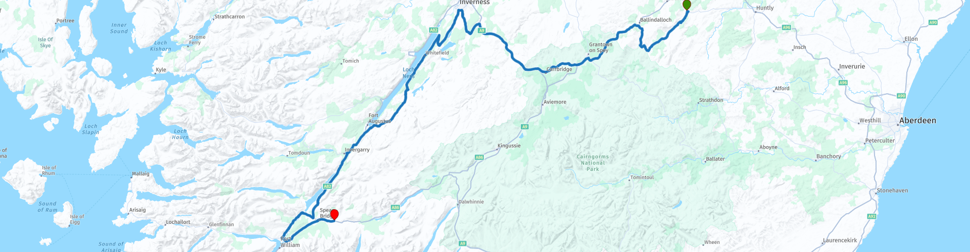
 The roads are good and the views are excellent! Today's route heads to Roy Bridge, a small village, which sits at the fork of the River Roy and the River Spean. This is three miles east of Spean Bridge in the Highland administrative area, the northern part of Scotland.
You can again enjoy the good roads, beautiful views and the mountainous area. Nature is very beautiful there, which is a pleasure again.
After about 20 kilometers you will see a parking lot on the left. Here you can park the motorbike to pay a short visit to the ruins of Castle Drumin (a monument). This is a ruined tower house near Scottish Glenlivet, Moray. The castle sits on a ridge above the junction of the rivers Livet and Avon.
After taking a few nice pictures you can pick up the route again. The route goes along the Cragganmore Hills which you can see slide past like a movie on your left. Splendid!
The route then passes through the town of Dulnain Bridge. The moment you enter this place, on the right side there is a landform created by glacial erosion. The "grinding" and "polishing" of a glacier creates an undulating surface of bedrock, which is often covered with other traces of glacial erosion, such as striations. They also call it Roche Moutonnée.
Then it's time to stretch your legs or drink a cup of coffee. A great opportunity for this is the Dores Inn, in the town of Dores. It is one of the most popular restaurants in the Inverness area, with a reputation for excellent food and is beautifully situated on the edge of Dores Beach, with iconic views across Loch Ness*. You can also choose to have lunch here because there are not many places further on the route that are suitable for this.
*Loch Ness is a large, deep loch in Scotland. The loch is 36.3 kilometers long and 1.6 kilometers wide at its widest part. The greatest depth of the lake is 226 meters. Loch Ness is set in hilly terrain. Because peat and peat continuously flows into the lake from these hills, the water is very turbid. There is also the Myth about Nessie.
For hundreds of years there have been rumors that a huge water monster lives in Loch Ness. Many indistinct photos of the beast have been taken, but its existence has never been proven. The first observations date from the seventh century. The myth attracts many tourists to the Scottish Lake.
After coffee you can continue the route in a southerly direction. It is a somewhat narrower road through a wooded area with Loch Ness on your right. When you have passed Loch Ness you will come across a beautiful swing bridge that lies over the Caledonian canal and ends up on the Loch Oich lake. This is a lake located between Loch Lochy and Loch Ness. Loch Oich is located in the Great Glen, a valley created because it is the fault line between two plates. The lake, together with several other lakes and a system of locks located in the southwest, forms the Caledonian Canal. On the bridge you look out on a beautiful hilly landscape.
After about 4 to 5 kilometers you have to pay attention. The route then turns left onto a small road and passes Invengarry Castle. This is one of the many ruins in Scotland. You can park there on the left to take a few pictures. Today you drive along a number of lakes, including Lake Oich and Loch Lochy, for example. This is a large lake, with an average depth of 70 meters. It is the third deepest lake in Scotland. It is about 16 kilometers long and 1 kilometer wide. Loch Lochy is located in the Great Glen, a valley created because it is the fault line between two plates.
If we now continue our route, it runs to the right after about 10 kilometers. At this intersection is a monument "Commando memorial". This is a memorial to the fallen soldiers. There was a lot of training here in the area by commandos in the Second World War.
The beautiful narrow roads with fantastic views then meander between the hills, and yes, it is confirmed that motorcycling in Scotland is a fantastic activity.
Then continue to the town of Banavie, where you have the opportunity to fill the tank at the waypoint for the next day.
Then it is about 15 kilometers to Roybridge where you can spend the night in the guest house Stonlossit Inn.
After a nice shower and a good meal you can enjoy the beautiful day there.
Along the route there are several possibilities to stop for a cup of coffee, something to eat or to take a picture. I have included a few places where we stopped in the details.
Particularities:
rp 1 Fife Arms
rp 10 Dores Inn
rp 22 Stonlossit Inn
Useful links:
Fife Arms Guest House - Dufftown
Dores Inn
Invergarry Castle
Command Memorial
Stonlossit Inn


 Links
Links  Usage
Usage Want to download this route?
You can download the route for free without MyRoute-app account. To do so, open the route and click 'save as'. Want to edit this route?
No problem, start by opening the route. Follow the tutorial and create your personal MyRoute-app account. After registration, your trial starts automatically.  Disclaimer
Use of this GPS route is at your own expense and risk. The route has been carefully composed and checked by a MyRoute-app accredited RouteXpert for use on TomTom, Garmin and MyRoute-app Navigation.
Changes may nevertheless have occurred due to changed circumstances, road diversions or seasonal closures. We therefore recommend checking each route before use.
Preferably use the route track in your navigation system. More information about the use of MyRoute-app can be found on the website under 'Community' or 'Academy'.