43 Mergelland route

This route was brought to you by:
RouteXpert Hans van de Ven (Mr.MRA)
Last edit: 28-08-2025
 Route Summary
 This is the crowning achievement of the ANWB's endangered routes. The South Limburg Mergelland region offers an almost foreign landscape with hills, sunken lanes, and picturesque villages. The roads are winding and challenging, perfect for motorcyclists. Sights like Maastricht, Simpelveld, and the Vijlenerbos forest add a touch of color to this ride. ★★★★★
As the name suggests, a tour through the Mergelland in South Limburg.
This is the 43rd and final route in the series of 43 Endangered ANWB routes. These were published in Promotors between April 2015 and September 2016.
 Share this route


Animation

Verdict


Duration
3h 41m

Mode of travel
Car or motorcycle

Distance
105.26 km

Countries

 RouteXpert Review
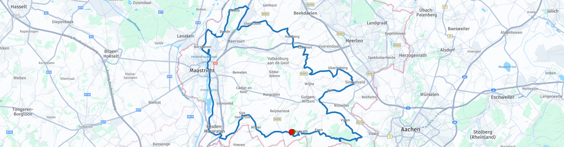
 You start in Slenaken at De Boswachter and quickly climb towards Epen and Camerig, where the landscape immediately treats you to panoramic views and winding roads. In Vijlen, the highest church village in the Netherlands, you'll experience the unique mix of hills, half-timbered houses, and vineyards. Via Mechelen and Wittem, you'll continue through the Geuldal Valley, passing monasteries, chapels, and old farmhouses. Simpelveld shows how marlstone defines the region's landscape, while the roads continue to challenge you with short climbs and descents. At Klimmen, you can pause for a moment and enjoy a view that lives up to the village's name. A stop at Pleinzicht completes the experience. The route then continues towards Maastricht, the cultural capital of Limburg. From the city, you delve back into the hills, past orchards and sunken lanes. Via Sint Geertruid, Noorbeek, and Hoogcruts, you'll cycle through the characteristic rolling hills of the Mergelland region back to Slenaken. A final stop at De Boswachter rounds off this tour perfectly.
The Mergelland route is undoubtedly the most beloved ride in the series. It's a series of highlights: winding roads, expansive views, and the unique atmosphere of South Limburg. A must-ride for every motorcyclist, and the ultimate conclusion to the 43 endangered routes.
Suggested breaks, information, fuel and viewpoints included in the route
• TSP – Tour Start Point; De Boswachter, Slenaken - Half-timbered restaurant with terrace, Burgundian atmosphere, limited opening hours.
• TIP – Tour Info Point; Vijlen - Highest church village in the Netherlands, surrounded by hills, forests and vineyards.
• TIP – Tour Info Point; Mechelen - Idyllic village in the Geuldal, with half-timbered farms and marl caves.
• TIP – Tour Info Point; Wittem - Known for its monastery and pilgrim chapel, starting point for tours through the Mergelland.
• TIP – Tour Info Point; Simpelveld - Characteristic Mergelland village, known for its marlstone and rolling hills.
• TPP – Tour Pause Point; Climbing - Picturesque village on a ridge, with a rich history and beautiful views.
• TPP – Tour Pauze Punt; Pleinzicht - Cozy café-restaurant in Klimmen, suitable for lunch or dinner.
• TIP – Tour Info Point; Maastricht - Cultural capital, gateway to the Heuvelland and Mergelland.
• TBP – Tour Fuel Point; Lukoil, Eijsden - Unmanned gas station, open 24/7, ideal for a fuel stop.
• TIP – Tour Info Point; Sint Geertruid - Village in the Heuvelland, surrounded by orchards, hills and marl caves.
• TPP – Tour Pauze Punt; Café 't Hemelke - Cozy cafe with terrace and affordable menu, long opening hours at weekends.
• TEP – Tour End Point; De Boswachter, Slenaken - Atmospheric half-timbered restaurant, Burgundian ending point of the route.


 Links
Links  Usage
Usage Want to download this route?
You can download the route for free without MyRoute-app account. To do so, open the route and click 'save as'. Want to edit this route?
No problem, start by opening the route. Follow the tutorial and create your personal MyRoute-app account. After registration, your trial starts automatically.  Disclaimer
Use of this GPS route is at your own expense and risk. The route has been carefully composed and checked by a MyRoute-app accredited RouteXpert for use on TomTom, Garmin and MyRoute-app Navigation.
Changes may nevertheless have occurred due to changed circumstances, road diversions or seasonal closures. We therefore recommend checking each route before use.
Preferably use the route track in your navigation system. More information about the use of MyRoute-app can be found on the website under 'Community' or 'Academy'.