Bochtig rondje door het Overijsselse Vechtdal

This route was brought to you by:
RouteXpert Marcel Scherpenkate
Last edit: 15-07-2021
 Route Summary
 I have equalized the route for TomTom, Garmin and MyRoute-app Navigation users.
I rate this route with 5 stars, I have driven this route several times myself and continue to enjoy the diversity of landscape and beautiful winding country roads
 Share this route


Animation

Verdict


Duration
8h 9m

Mode of travel
Car or motorcycle

Distance
251.56 km

Countries


 RouteXpert Review
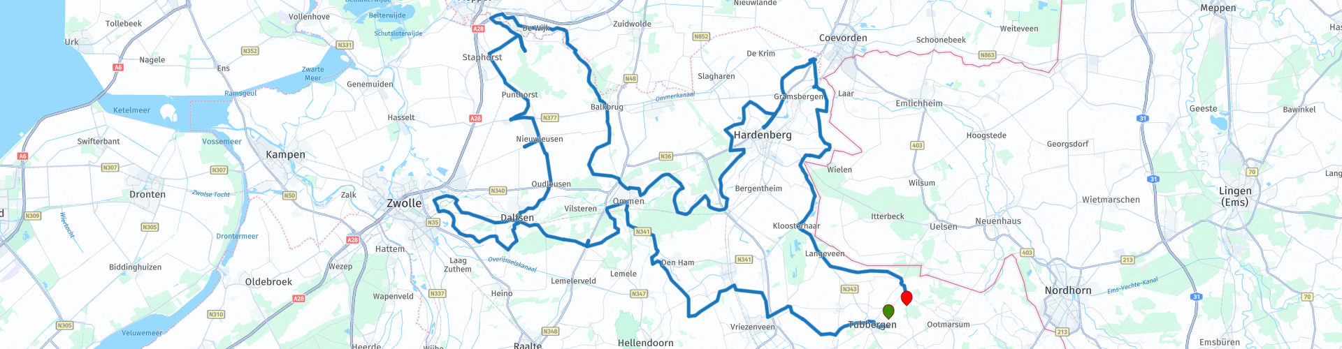
 The Overijsselse Vecht is a rainwater river in Germany and the Netherlands. The river is 167 kilometers long, of which 60 km in the Netherlands. Its origins lie in the German Münsterland. The source is formed by the moat of Castle Darfeld. The fight eventually flows into the Zwarte Water at Zwolle.
The catchment area of the Overijsselse Vecht covers a total of about 3,780 square kilometers. The Overijsselse Vecht played an important role in shipping well into the nineteenth century. In particular for the cultivation of peat areas.
Important tributaries that join the Overijsselse Vecht are the Dinkel, the drainage canal at Gramsbergen and the Regge. Important places and municipalities along the Overijsselse Vecht are: Nordhorn, Neuenhaus, Hoogstede, Emlichheim, Gramsbergen, Hardenberg, Mariënberg, Ommen, Vilsteren, Dalfsen and Zwolle. You visit a number of these places in this route.
After Ommen, some 30 km through hamlets such as Hoonhorst and Wijthmen, to the east of Zwolle, just before Berkum you drive via the forelands of the Vecht via a beautiful dyke back to Dalfsen where you are offered the opportunity to stop for lunch at Brasserie de VII Virtues. A favorite lunch spot for motorcyclists. From the terrace you have a beautiful view over the floodplains of the Vecht.
After lunch you drive through the Stokte, a truly beautiful area along the banks of the Vecht. Halfway through you can stop at the lookout tower 'De Stokte' for a beautiful view over the Vechtdal. Please note, there is no parking space that you have to do along the road and on the verge. You continue the route towards Nieuwleusen where you can visit the motorbike shop Ten Kate.
After this, the route continues in the direction of Meppel via Boswachterij Staphorst through de Wijk via again a rural area with beautiful winding roads. You drive towards the provincial border with Drenthe to the Reestdal.
The Reestdal lies on the border between Overijssel and Drenthe and here the Reest meanders for tens of kilometers through the landscape. An ancient and small-scale beautiful cultural landscape with forest, heather, hay meadows and authentic farms, which give you the feeling of being in different times. Because of the small scale and variety you will be surprised and delighted again and again.
Eventually you will arrive in Ommen enjoying themselves where you will meet the fight again. After Ommen you cross the Vecht several times through the Vechtdal. Winding through the floodplains, via the weir in Junne to the weir in Diffelen. To be precise, the Mölnmarsch site near Mariënberg where you can enjoy the view of the Distelbeld.
Via the Hardenberg recreation area the Oldemeyer you drive north of Hardenberg towards the hamlet of Holthone where you can make a stop at the pancake restaurant De Ganzenhoeve for a cup of coffee, for example.
The last 50 km of this route goes along the German border, on beautiful winding roads to the end point Recreation Park `n Kaps.


 Links
Links  Usage
Usage Want to download this route?
You can download the route for free without MyRoute-app account. To do so, open the route and click 'save as'. Want to edit this route?
No problem, start by opening the route. Follow the tutorial and create your personal MyRoute-app account. After registration, your trial starts automatically.  Disclaimer
Use of this GPS route is at your own expense and risk. The route has been carefully composed and checked by a MyRoute-app accredited RouteXpert for use on TomTom, Garmin and MyRoute-app Navigation.
Changes may nevertheless have occurred due to changed circumstances, road diversions or seasonal closures. We therefore recommend checking each route before use.
Preferably use the route track in your navigation system. More information about the use of MyRoute-app can be found on the website under 'Community' or 'Academy'.