TTT 2015 01 Spijkenisse Oud Beijerland

This route was brought to you by:
RouteXpert Hans van de Ven (Mr.MRA)
Last edit: 19-04-2021
 Route Summary
 The 173 ANWB Promoter TankTasTocht (TTT) were scanned by Henry ten Dam and signed by Leon Stolk in Mapsource and later placed as a Track in a .gpx file. These are made available through the MrGPS website with the approval of the ANWB Promoter so that everyone can enjoy them. The 1st TTT is from 1992, so the route may differ slightly from the original.
I have checked all route points and, where necessary, placed them neatly on the road. Also, if necessary, I have further spaced the start point and end point of the route to avoid navigating directly to the end point and I added the POI files from the start and end point just like a possible stopping point.
Finally, I made the route the same for TomTom, Garmin and MyRoute-app Navigation users.
Thanks to Henry, Leon, MrGPS and Promoter.
 Share this route


Animation

Verdict


Duration
3h 55m

Mode of travel
Car or motorcycle

Distance
118.14 km

Countries

 RouteXpert Review
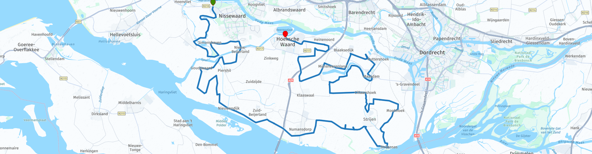
 Quite soon after you leave Sppijkenisse, you pass the Bernisse, which runs from the Spui to the Shipping and Nutrition Canal that runs parallel to the Hartel Canal. Immediately afterwards you can have a photo at the Arend, this is a flour mill from 1844 located in the Zuid-Holland town of Zuidland. The white plastered, round stone scaffolding mill is located on the Molendijk. Pieter de Gilde commissioned the mill to be built by Dirk David van Dijk as a replacement for a burnt-out wooden mill.
We continue and normally pass the Bernisse and then the Spui, this is a tidal river in South Holland that forms the connection between the Oude Maas and the Haringvliet. The Spui forms the separation between the islands of Voorne-Putten and the Hoeksche Waard. The Spui was created as a result of the storm flood of 2 November 1532, during which a dike breach made the connection between the Spui and the (Oude) Maas. We drive on again and just before we have coffee, you can take some pictures at the Dirty Hole, this is the stretch of water between Zuid-Beijerland / Nieuwendijk and the island of Tiengemeten. The Vuile Gat connects both east and west to the Haringvliet. A ferry crosses the Vuile Gat from Nieuwendijk to the nature island of Tiengemeten.
After the coffee / lunch stop in Numansdorp we pass the Sassenplaat, this is an uninhabited island in the Hollandsch Diep near the Moerdijk harbor and industrial area in the municipality of Moerdijk and used as a nature reserve managed by Staatsbosbeheer. Then you can still spot some birds at the Oudeland of Strijen, this is mainly known for the pygmy geese that hibernate there every year. But red-necked geese and small reed geese are also seen here every now and then and the more common common geese, greylag geese and barnacle geese. The viewpoint is at an old restored pumping station with a beautiful view over the small waters and the wet meadow. There is an information panel, a picnic table and a toilet.
We continue our way and pass successively the places Maasdam, Puttershoek, Mijnsheerenland, and Westmaas. At Heinenoord along the N217, you see the statue of Mother on the other side of the road, this is a war memorial on the spot where ten people were shot on 28 February 1945, as a reprisal for the murder of NSB mayor MA Simonis.
Another 6 KM drive and then we are at the terminus in Oud-Beijerland, where you can quietly go through the route on the terrace while enjoying a drink.
Because I have not (yet) driven this route myself, this route gets 3 stars.
Route details:
rp 4 - The Eagle
rp 17 - The Dirty Hole
rp 18 - t Schippershuis. - Coffee / lunch stop
rp 23 - The Sassenplaat
rp 29 - The Oudeland of Strijen
rp 41 - Mother


 Links
Links  Usage
Usage Want to download this route?
You can download the route for free without MyRoute-app account. To do so, open the route and click 'save as'. Want to edit this route?
No problem, start by opening the route. Follow the tutorial and create your personal MyRoute-app account. After registration, your trial starts automatically.  Disclaimer
Use of this GPS route is at your own expense and risk. The route has been carefully composed and checked by a MyRoute-app accredited RouteXpert for use on TomTom, Garmin and MyRoute-app Navigation.
Changes may nevertheless have occurred due to changed circumstances, road diversions or seasonal closures. We therefore recommend checking each route before use.
Preferably use the route track in your navigation system. More information about the use of MyRoute-app can be found on the website under 'Community' or 'Academy'.