Day 06 North Cape Tour Furoy Lofoten Reine

This route was brought to you by:
RouteXpert René Plücken (MRA Master)
Last edit: 27-02-2021
 Route Summary
 You drive longer distances in Norway without encountering a gas station or restaurant, keep this in mind before you drive. Make sure your tank is full and bring food and drinks. Bring a few bottles of water or Camel bag and fill it up when you stop to refuel. A number of breaks have been planned along the way for refueling, eating and drinking.
You have the choice to spend the night at campsites or in hotels. Hotel prices in Norway are not particularly high and breakfast is usually included. Camping is free almost everywhere, except on private property or where camping is prohibited, indicated by prohibition signs. If you don't want to camp, there are often cabins for rent on the campsites. For a trip through Norway it is always advisable to bring a tent and other camping gear.
I rate this route with 5 **** stars because of the beautiful roads, beautiful nature and some beautiful places to stop.
 Share this route


Animation

Verdict


Duration
10h 28m

Mode of travel
Car or motorcycle

Distance
295.70 km

Countries

 RouteXpert Review
 Just outside Furøy is a gas station (RP2) to fill up for this beautiful day. Today we also drive through a number of tunnels, so keep that in mind, it can be colder and more humid in the tunnels.
The Fv17 runs along the fjords so with good weather you can fully enjoy the beautiful panoramas, along the route there are several beautiful and well-laid out parking spaces where you can stop to take a break or take a few photos, such as at RP9 Ureddplassen, this is one of the most beautiful public toilets in the world. The view of the Norwegian Sea is breathtaking.
At the Storvika Rasteplass (RP10) you can also stop for a short photo break. There is also a shop and a gas station for refreshments. Just after the next tunnel you can stop on the right at the viewpoint (RP12) to admire the view of the Sørfjorden, a 38 km long fjord that is one of the innermost branches of the main Hardangerfjorden. It is the longest arm that branches off the Hardangerfjord. It stretches from just north of the village of Kinsarvik in a southerly direction to the industrial town of Odda.
At RP13 you can visit “The Forgotten City”. After a short walk from the parking lot, you'll see a stage built for something that could have happened, but is now empty, awaiting its future. The basic idea behind this construction seems to be the temporary paradoxes. Stone as the primordial material is formed into something that resembles both a ruin and the basic structure of a building to be built: past and future exist in the present.
We drive on to Bodø, crossing several beautiful bridges along the way. You can't always stop to take a picture, but these structures are truly beautiful.
At RP17 we drive across the Kjellingstraumen Bridge, a suspension bridge that crosses Kjellingsundet Street at the mouth of the Beiar Fjord. The 662 meter long bridge was opened in 1975 and the longest span is 260 meters.
At RP18 you will see a beautiful waterfall on your right hand side over the rocks in the river Valnesevla.
Park at RP19 to take a photo of the beautiful Åselistraumen bridge over the Åselistraumen strait. The concrete bridge is 200 meters long and the longest span is 30 meters.
At RP21 we drive across the Saltstraumen Bridge, a cantilevered box girder bridge, opened in 1978, that traverses the Saltstraumen strait between the islands of Knaplundsøya and Straumøya. The bridge is 768 meters long, the longest of the 10 spans is 160 meters and the maximum distance from the sea is 41 meters. The bridge is made of prestressed concrete.
At RP22 a slightly longer stop has been planned to view Godøystraumen. This is one of the many tidal currents along the coast of Helgeland. The currents are created by the tide when enormous amounts of water are forced in and out of narrow inlets and create powerful eddies. The rest area at the narrow inlet leading to Godøystruamen offers a close-up view of the streams and the ocean beyond.
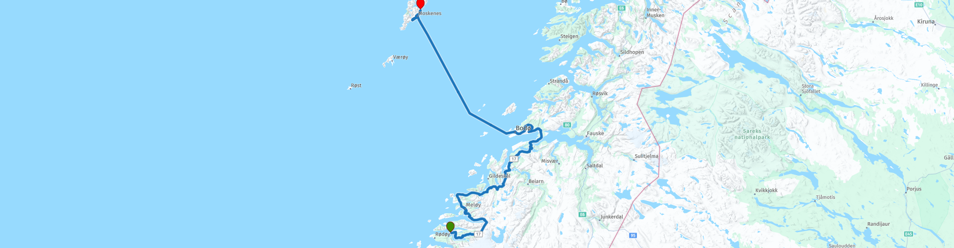
In Bodø (RP26) we take the ferry to Moskenes (RP27), a municipality in Lofoten. The crossing takes 3 hours and 15 minutes and the costs are between € 25 and € 35. On board you can rest well, eat and drink something and enjoy the beautiful view on deck.
We leave Moskenes and drive to the town of Sørvågen (RP28) where you can explore the beautiful Lofoten. The Lofoten consists of a number of islands. The most famous are: Røst Værøy Gimsøya Moskenesøya Vestvågøy Austvågøy Flakstadøya Some places in Lofoten are Svolvær, Leknes, Vågan, Ramberg, Moskenes and Reine.
Lofoten is known for its excellent fishing, natural attractions such as the Northern Lights and the Midnight Sun, and small villages off the beaten track. Kayak between the islands, go fishing for the catch of a lifetime, or look for sea eagles soaring in the air. Planning an extra day on the Lofoten is definitely recommended.
There is a camping site in Sørvågen as an alternative to the Hotel Reine Rorbuer (RP30) at the end of this beautiful day.


 Links
Links  Usage
Usage Want to download this route?
You can download the route for free without MyRoute-app account. To do so, open the route and click 'save as'. Want to edit this route?
No problem, start by opening the route. Follow the tutorial and create your personal MyRoute-app account. After registration, your trial starts automatically.  Disclaimer
Use of this GPS route is at your own expense and risk. The route has been carefully composed and checked by a MyRoute-app accredited RouteXpert for use on TomTom, Garmin and MyRoute-app Navigation.
Changes may nevertheless have occurred due to changed circumstances, road diversions or seasonal closures. We therefore recommend checking each route before use.
Preferably use the route track in your navigation system. More information about the use of MyRoute-app can be found on the website under 'Community' or 'Academy'.