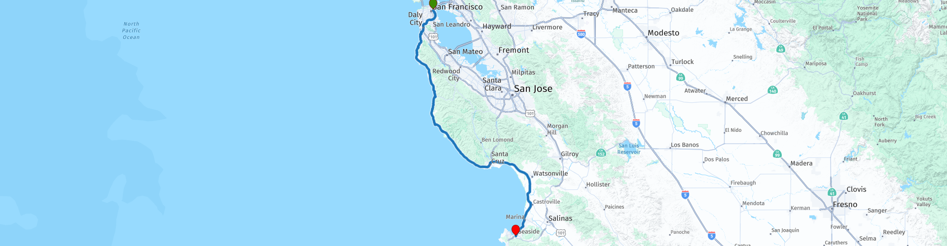
R13 San Francisco Monterey

This route was brought to you by:
RouteXpert Hans van de Ven (Mr.MRA)
Last edit: 02-05-2021
 Route Summary
 During this journey you will travel through the following states: California, Arizona, Utah & Nevada.
The roads are good, the views amazing. After all the mountains, forests and (giant) trees, now sea & wind, get a breath of fresh air and enjoy along the coast!
Starting point: The Pickwick Hotel.
End point: Ramada Carmel Hill Monterey.
The route has been made the same for TomTom, Garmin and MyRoute-app Navigation users.
Thanks to Richard & Lisa for the information!
 Share this route


Animation

Verdict


Duration
3h 39m

Mode of travel
Car or motorcycle

Distance
190.63 km

Countries

 RouteXpert Review
 Carmel by the Sea, the town that became famous because Clint Eastwood was chosen as mayor when he had problems with a permit, is a very pleasant, albeit somewhat touristy resort with nice restaurants, shops and good beach. Monterey is a little further north on the peninsula. For shelter and good
Fish restaurants can probably be found easier and cheaper in Monterey. Both places have their history. Carmel was founded by the Spanish missionaries who were the first Europeans to build settlements here. The Carmel Mission remains, one of the most beautiful in the chain of mission posts along the California coast. At Monterey people always think of a fishing village with fish processing factories on the water. This is because of John Steinbeck, who lived here for years and sketched an unforgettable image of the town in the 1930s in Cannery Row. To be honest, that is better, because now Cannery Row has become a tourist attraction. They still eat excellent fish, but just like the Fisherman's Wharf in San Francisco, the whole gets some artificial features. At the tip of the peninsula, between the two towns, lies Pacific Grove, a quiet tourist town that has a kind of timeless feeling about it. Summer camps of Methodists took place here from the end of the nineteenth century. The camps they built later became the core of the populist chautauqua movement that brought culture and educational entertainment to places that were completely isolated (such as Asheville, for example). Along the coast between Pacific Grove and Carmel is not Route One but Seventeen Mile Drive, the most famous toll road in the country. This route is no longer as wild as before. That is also not possible with two of the best known (and most expensive) golf courses in the world: Pebble Beach and Cypress Point. The rich visitors to the golf courses have now also placed their country houses and expensive hotels here. It is and remains a beautiful route, but no more spectacular than what one can see from Ocean Boulevard in Pacific Grove or the Scenic Drive in Carmel, not to mention the rest of Route One. You can watch and photograph one of the most famous places in California yourself, namely the Lone Cypress. Before continuing on Route One you will pass Point Lobos State Park just outside Carmel. It is one of the last places where there are still forests with the Monterey cypress in all its beauty sculpted by wind and sea. It is also a good place to see seals and whales in the winter.
In this 4-star route you will drive along the coastline, where there are plenty of opportunities to stop for a picnic on the coast. Don't forget your picnic stuff!
General information:
The coastal route
The California coastline has a length of 1350 km and consists for the most part of rugged and rocky areas. The south of this coastline, however, is blessed with beautiful sandy beaches. There are four major rivers that cross the state, namely the Sacramento River, the San Joaquin River, the Salinas River and the Colorado River that
forms the border between the state and Arizona. The latter river also gives water to major cities such as Los Angeles.
There was a time when Cambria, Big Sur, and other villages on the coast of Central California were completely isolated and known for their seclusion and tranquility. Times have changed. Not only has the road, which until 1937 died on both sides, now been fully extended. After Big Sur was discovered by hippies and other people in the 1960s,
This has become a first-rate tourist destination. The most important reason for this is the beautiful and impressive landscape. As far as southern California is concerned, Route One starts in San Francisco. In fact, this coastal road begins on the Canadian border and follows the entire Pacific coast. Those who want to take the time can follow the entire route from Mexico to Canada, and will never be bored. But in this route it is limited to the south of San Francisco, and then you actually only start at Monterey, about two hundred kilometers further south. Although the stretch between San Francisco and Santa Cruz is very beautiful in some parts and with its endless dunes shows a completely different side of the state, Route
One really spectacular from Monterey. When Pacific Highway near Santa Monica gets hold of Los Angeles, he loses much of his appeal. Bixby Creek Bridge, some twenty miles south of Carmel, is considered the beginning of the Central Coast.


 Links
Links  Usage
Usage Want to download this route?
You can download the route for free without MyRoute-app account. To do so, open the route and click 'save as'. Want to edit this route?
No problem, start by opening the route. Follow the tutorial and create your personal MyRoute-app account. After registration, your trial starts automatically.  Disclaimer
Use of this GPS route is at your own expense and risk. The route has been carefully composed and checked by a MyRoute-app accredited RouteXpert for use on TomTom, Garmin and MyRoute-app Navigation.
Changes may nevertheless have occurred due to changed circumstances, road diversions or seasonal closures. We therefore recommend checking each route before use.
Preferably use the route track in your navigation system. More information about the use of MyRoute-app can be found on the website under 'Community' or 'Academy'.