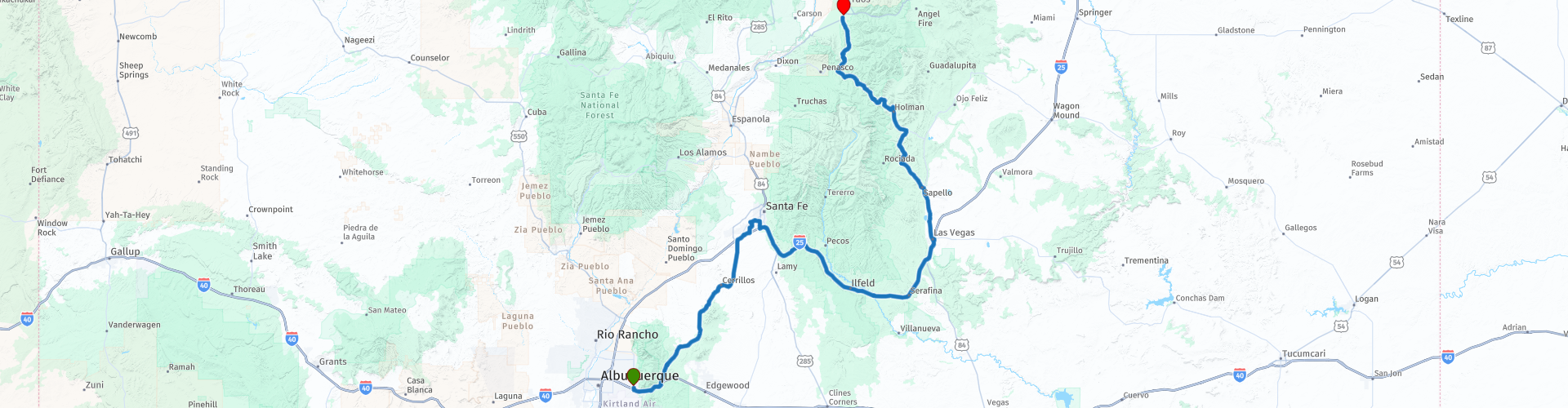
Albuquerque to Taos New Mexico

This route was brought to you by:
RouteXpert Paul Hedges - Adv RouteXpert
Last edit: 09-01-2021
 Route Summary
 Mix this with sweeping curves, old Route 66, free flowing Highways along roads with names like, Sante Fe Trail, the Turquoise Trail and The High Road to Taos and it just screams out adventure.
Then add in movie filming locations for Swayze and Travolta, sights along the way of dinosaurs and giant robots and what more is needed?
A really mixed up 4 star day
 Share this route


Animation

Verdict


Duration
6h 11m

Mode of travel
Car or motorcycle

Distance
332.10 km

Countries

 RouteXpert Review
 Heading North from Tijeras the NM-14 heads to Sante Fe along the Turquoise Trail through rolling hills with mountain views and quaint historic mining towns.
On the NM 14, don’t blink twice, or you’ll miss the ghost town of Golden, site of the first gold rush west of the Mississippi, in 1825. The booming town supported saloons, businesses, a mercantile store, a school and a stock exchange. The small but ornate San Francisco Catholic Church, built in 1830, is still in use.
Stop at Maggie's Diner in Madrid and enjoy the food while take in the movie backdrop from Wild Hogs, Madrid was the town that John Travolta, Tim Allen and Co protected from Ray Liotta and his Del Fuegos MC.
The road continues North across wide open to scrub land until it arrives in Sante Fe.
Arriving in Santa Fe we stop by a Family of Brontosaurus (RP11), stood by the side of the road as a T-Rex erupts from the wall beside them.
Just one of the strange roadside displays that pepper themselves across America. Case in point a car park in Santa Fe (RP15) where you can see a 30 foot Robot, 20 foot spider and an elephant sized Coyote.
All part of the Meow Wolf Arts Complex and will keep anyone entertained if they want to just stop for a photo or spend time and look through the whole collection.
After a stop and Blimpies for coffee we join the the I-25 and navigate around the Santa Fe National Forest to arrive at Las Vegas, NM.
Las Vegas was used as the fictional town of Calumet, Colorado that was invaded by Cuban, Nicaraguan, and Soviet troops in the war film Red Dawn.
The town still displays a giant mural that says Howdy Calumet on one of the buildings (RP27)
Continuing North on the 518 the scenery starts to change. As you leave Sapello the scrub grassland changes to be a more alpine-like with tall trees standing beside the sweeping undulating curves.
This is easy riding with stunning views around each corner. After 60 miles of this road that gets as high as 9000 feet and even passes a ski resort, at Rock Wall the rood points itself to Taos.
This is the end of the road for this journey. But the start of a New Mexico road trip where this is just part 1. A really mixed and interesting 4 star day


 Links
Links  Usage
Usage Want to download this route?
You can download the route for free without MyRoute-app account. To do so, open the route and click 'save as'. Want to edit this route?
No problem, start by opening the route. Follow the tutorial and create your personal MyRoute-app account. After registration, your trial starts automatically.  Disclaimer
Use of this GPS route is at your own expense and risk. The route has been carefully composed and checked by a MyRoute-app accredited RouteXpert for use on TomTom, Garmin and MyRoute-app Navigation.
Changes may nevertheless have occurred due to changed circumstances, road diversions or seasonal closures. We therefore recommend checking each route before use.
Preferably use the route track in your navigation system. More information about the use of MyRoute-app can be found on the website under 'Community' or 'Academy'.