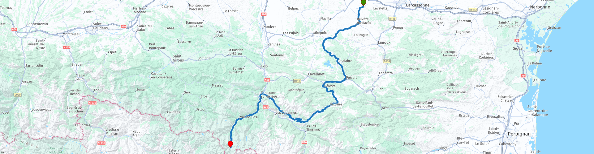
AUDE Montreal Tarascon Etang de Soulcem

This route was brought to you by:
RouteXpert Steve Montreal
Last edit: 17-04-2024
 Route Summary
 This route gains its 4* rating from its thrilling combination of beautiful landscapes, flowing roads, ancient history and a wonderfully peaceful and scenic destination.
 Share this route


Animation

Verdict


Duration
5h 43m

Mode of travel
Car or motorcycle

Distance
169.79 km
 RouteXpert Review
 The Collegiale St.Vincent now dominates the town and is built on the site of the old castle.
In 1209, Montréal was taken and razed by Simon de Montfort´s troops during the Albigensian Crusade, a brutal campaign to rid the area of the Cathar religion.
After the siege, the Lord of Montréal, was hanged, his sister was thrown into a well, 80 of his knights were executed and up to 400 Cathars were burned to death.
Formerly an important centre of gunpowder production, Montréal is today much more peaceful.
Leaving Montreal, you pass by the small town of Villeneuve-les-Montreal, which goes back to 888. Much of the present village was built by a bourgeois Cathar and is one of the seventeen circular villages of the Aude.
The ride through the fertile rolling countryside of the old ‘County of Razes’ is identified by the many village names that still bear the old name.
The County of Razès was a feudal jurisdiction in Occitania, south of the County of Carcassonne, in what is now Southern France. It was founded in 781, after the creation of the Kingdom of Aquitania.
Later you approach the Château de Lagarde, which is a ruined castle in the Ariege. Following the Albigensian Crusade, the castle was handed to the Lévis-Mirepoix family. The castle was very much transformed in the XVIIth century, before being completely destroyed during the French Revolution.
Today it is often the scene of many historical events, medieval days, fireworks, and motorcycle rallies.
The Mototrail Cathar, a three day adventure bike navigation rally, was a recent event.
Nicknamed "Little Carcassonne", the fortified village of Camon nestles around an ancient Benedictine abbey and is one of "France's Most Beautiful Villages".
The origins of the abbey date back to 923 and possibly earlier, however the original abbey and the village were destroyed along with Mirepoix and many other villages in the area in 1289 when a natural dam gave way.
The village was rebuilt in the 14th century during the Hundred Years War in the style of a royal fortress, including a crenellated defensive wall that surrounded the church and abbey buildings but not the village.
Among the gems to explore are the Clock Gate (Porte de l'Horloge), Tall House (Maison Haute) ramparts, abbey-château and 16th-century church and treasure house.
Also known as "the village of 100 rosebushes", Camon is in bloom with a multitude of roses every May. The rosebushes were given to the village by vine growers who used roses as an early warning system against diseases of the vines, since the roses would be attacked first giving the winegrowers a chance to take action to protect the vines.
This magnificent sight is honoured with an annual rose festival on the third Sunday in May.
From Camon you will follow the course of Le Grand Hers river to the bastide town of Chalabre. Bastide towns were built as the “new towns” of the 13th century, designed to be both defensively strong and to regenerate the regions that had been ravaged by wars. They conformed to a very distinctive design: a central square following a grid pattern, where the streets radiate out and where the central square, the hub of town life, is decoratively arcaded, often with a free standing, covered market area.
The original medieval village experienced serious flooding in 1279, and it was deemed necessary to ‘raise’ the level of the houses that border the three rivers (L’Hers, Le Blau, & Le Chalabriel) that meet in the south west corner of the town
The bastide wall has long since given way to the road that wraps around the central part of the town.
In Puivert the 12th century Château de Puivert is a so-called Cathar castle.
Today a semi-ruined tourist destination, the castle’s functions were military – providing a lookout and defence, unlike many buildings of the era which had religious goals.
Overlooking Puivert, the castle belonged to the Congost family before the Albigensian Crusade.
These lords practised Catharism (unorthodox Christianity) and were accused as heretics.
In 1210, the castle was subjected to a siege for thee days by the army of Thomas Pons de Bruyère, lieutenant of Simon de Montfort.
Subsequently, Puivert Castle became the property of the northern barons.
All that is left of this older castle is a few sections of wall to the east.
At the start of the 14th century a new castle was built to the east of the old castle and the best preserved element is the square keep.
The remains of the old castle are still visible, high on the hill, as you leave the town.
The historical past of Belesta in the 15th century revolves around the Lord of Audou, a fiery Huguenot captain from the Lévis de Mirepoix family.
The castle can be seen in the centre of the village and the ruins of its sister castle of Amont, which housed its garrison, on the other bank of the Hers river.
A slight diversion from the main route takes you to the Fontaine de Fontesorbes, allegedly the most spectacular intermittent fountain in the world.
Although for most of the year, the fountain is constantly flowing, in periods of low water, it can suddenly become intermittent by a phenomenon of rhythmic and regular variations of the flow.
The complete cycle takes about 60-90 minutes.
The intermittence of the fountain has never been fully explained because divers have never succeeded in identifying the siphon which causes the phenomenon.
The legend: the cave, now obstructed, gave access to a sumptuous residence where the Encantados lived, fairies who, at nightfall, washed their laundry in the spring, with golden beaters....
Fewer than thirty intermittency phenomena have been identified worldwide.
Leaving Belesta you climb up to the 898m Col de la Croix des Morts (cross of the dead) to join the road through the high level Plateau de Sault, which sits at 850-1300m.
At the Col de Marmare the pace slows as you navigate the smaller D2 that follows the contours high above the Ariege Valley to Tarascon-sur-Ariege.
Along the way you will pass under a curious looking cable car system which is used to bring talc from the high altitude quarry to the processing plant in the bottom of the valley.
Established in 1905, the vast talc quarry of Trimouns, the largest open-air talc quarry in the world, is situated at 1800m altitude above the Ax valley in the Ariège department.
It produces 400,000 tons of talc per year.
The seam of talc at Trimouns was formed 300 million years ago in a fault between two masses of rock. The exploitation of talc here only began in the early 19th century.
The soft, white stone was ground in flour mills and the resulting talcum powder taken to Toulouse to be sold to druggists and apothecaries.
Until 1860 it was transported by mules (the difference in elevation is 1000m between the quarry and the village 15kms away). In 1888 mining began on a more organised scale and ox carts were used.
Transporting material down to the processing plant on the valley floor within the village of Luzenac from the quarry is what makes the operation unusual - the site has a cable car system for the purpose.
Roads leading up to the site are just not suitable for regular trafficking by the quarry's rigid or articulated dump trucks.
The existing cable car system was installed in the 1970s but was very forward-thinking for its time - it features a dynamo that helps to provide around 80% of the power needed for the quarry.
The quarry itself is a grandiose spectacle - everything is gigantic; on huge terraces, enormous machines uncover, extract, sort and transport the talc with the peaks of the Pyrenean chain as a backdrop.
There is one guided tour per day from mid-May to mid-October - enquire at the tourist office in Ax-les-Thermes.
Nestled in the heart of the Ariège Pyrenees valleys, the town of Tarascon-sur-Ariege can be seen from afar with its Castella tower posted on its rock since the 18th century.
Bordered by two rivers, the Ariège and the Vicdessos, this pretty little town is the gateway to Haute-Ariège.
The Castella tower was built on the site of the old medieval keep which was rectangular in shape. It was erected in the 18th century following the demolition of the so-called Foix gate, many of whose materials, in particular the bell and the clock, were reused for the construction.
The Tower is now where one has the best view of the surrounding area can be found.
A real commercial crossroads in the Middle Ages, its perfect location between the Ariège valleys attracted much envy during the religious wars that shaped the city that exists today.
Soon after leaving Tarascon, you enter the Vicdessos valley and arrive at Naiux where you will find the Grotte de Naiux (Cave of Niaux).
These caves are among the last decorated caves to be still open to the public.
The Niaux Cave's system is complex and has a combined length of more than 14km of underground passages and chambers. Niaux contains numerous distinct areas and galleries of carefully drawn and vivid wall paintings from the Magdalenian period, between 17,000 and 11,000 years ago.
The caves are open every day from February to October.
Tours of the caves are available & must be pre-booked on-line as numbers are limited.
**If you choose to visit the caves, allow 2 hours. (this has not been factored into the route timings)**
Leaving Naiux you will begin the long 1100m climb to the Dam and Etang de Soulcem passing the pretty Cascade de Auzat along the way.
Check the sign near to the Cascade, as in winter ( November onwards) the final 10km or so can be closed due to snow, as that part of the route is pastoral & not cleared of snow.
The Étang de Soulcem is at an elevation of 1570m and is used for hydroelectricity, generating 62GWh/year.
The lake, was formed following the construction, by Électricité de France (EDF), of a dam across the northern end of the Vicdessos valley in 1980–1983.
The lake water is often the most magnificent blue colour, as it was for our last visit in October 2023.
After the lake you will come to the end of the tarmac & the end of the route at a small scenic car park and picnic area.
Take a seat and enjoy a well earned rest in tranquil surroundings.
The on-site tourist information warns of the precautions for dealing with bears!, although a recent survey suggests that there are only 64 bears in the Pyrenees, so you are unlikely even to see one.
You are far more likely to see marmottes, which are not so intimidating.


 Links
Links  Usage
Usage Want to download this route?
You can download the route for free without MyRoute-app account. To do so, open the route and click 'save as'. Want to edit this route?
No problem, start by opening the route. Follow the tutorial and create your personal MyRoute-app account. After registration, your trial starts automatically.  Disclaimer
Use of this GPS route is at your own expense and risk. The route has been carefully composed and checked by a MyRoute-app accredited RouteXpert for use on TomTom, Garmin and MyRoute-app Navigation.
Changes may nevertheless have occurred due to changed circumstances, road diversions or seasonal closures. We therefore recommend checking each route before use.
Preferably use the route track in your navigation system. More information about the use of MyRoute-app can be found on the website under 'Community' or 'Academy'.