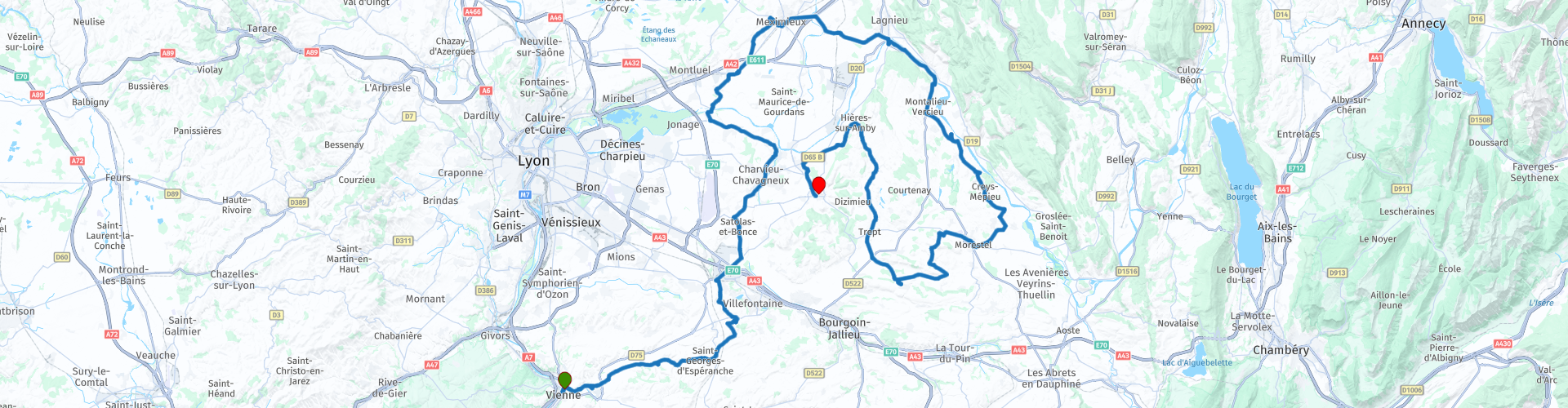
Dauphine region from Vienne

This route was brought to you by:
RouteXpert Jan Koelstra (jan cabrio)
Last edit: 30-05-2025
 Route Summary
 Some may be familiar to you, such as the towns of Crémieu, Morestel, Saint-Chef, Vertrieu and Quirieu. Others are less visible, such as the picturesque villages around the Balcons. But they are all exceptional for their cultural heritage, their panoramas, their hidden treasures. The best part: they are all easy to visit all year round with the help of free guided tours!
The unique area of Les Balcons du Dauphiné is characterised by its medieval heritage, authenticity and biodiversity. That is why this discovery tour, which also takes you along pleasant roads, has been awarded a five-star rating.
 Share this route


Animation

Verdict


Duration
7h 22m

Mode of travel
Car or motorcycle

Distance
189.13 km

Countries

 RouteXpert Review
 Your tour starts in Vienne. The city has more than 40 historical monuments and sites. On the banks of the Gère, you can find the remains of the ramparts of the old Roman city and east of the city there are the remains of a Roman stadium; there are also the ruins of a 13th century castle built on Roman foundations. There are also aqueducts and traces of Roman roads, a temple built by Claudius I in honour of Augustus and Livia and a Roman building whose function is (still) unknown. You can refuel just outside the city in Pont-Evèque at the local Carrefour.
The name of the commune of Septème probably derives from a Roman milestone; the place was located seven miles east of Vienne on the road to Italy. The old castle was built on top of a hill in the 10th century. Only a ruin remains of this castle. The counts of Savoy fortified the place in the 13th century against the Dauphiné. During the Renaissance, the castle of Septème was considerably adapted to the architectural style of the time. The 13th-century fortifications extend for a kilometre around the current complex with its 16th-century appearance.
The Château de Moidière is a castle in the French commune of Bonnefamille. The castle has been a protected historical monument since 1983. This castle of Moidière has a beautiful roof in Dauphinois style. The vestibule boasts Italian decors and a 'trompe-l'oeil'. In the animal park around the complex, the fauna of the region can be discovered.
The medieval town of Pérouges is situated on a hill, from the city walls you look out over the Ain valley. Because the town went through economically lean years in the 19th century, it is still in a reasonably original state. Pérouges is a member of Les Plus Beaux Villages de France, but is still relatively undiscovered by mass tourism. There is no car traffic in the town, except for local traffic. There is a small museum, a hotel, several restaurants and galleries. Pérouges has managed to retain a beautiful medieval architecture from the 13th and 17th centuries, with narrow, winding cobbled streets and half-timbered houses. Several filmmakers have shot famous films here, including the first film The Three Musketeers. Be sure to visit the fortified church, almost unique in France, the Porte d'En-Haut, the last remnant of the castle from the 12th century and the Place de la Halle in the heart of the city. In the local museum, housed in a former innkeeper's house, you will find various elements related to everyday life.
The diversity of monuments and other sights in the town of Vertrieu, such as a refrigerator dating from 1716, the two castles or the rural "Jardin des Simples" make Vertrieu an interesting stopover on the territory of the Balcons du Dauphiné.
Vertrieu owes its growth largely to its geographical location, in the hollow of a loop of the Rhône, which has allowed it to develop its port activity for centuries. This very strategic location dates back at least to the High Middle Ages, as evidenced by the tombs discovered in the Rue des Juifs.
The architecture of Vertrieu at the end of the Middle Ages is both urban with its narrow plots along the streets and rural with its external staircases typical of winegrowers' houses, but more generally of agricultural commercial activities.
But although the Rhône is intrinsically linked to the history of the village, the two so-called 'old' and 'new' castles define the landscape as much as the history.
So, if you love romantic walks in the heart of nature or strolling along the banks of the Rhône, or if you are a lover of medieval or classical heritage, let yourself be won over by the charm of Vertrieu!
Perched on a limestone hill overlooking the Rhône, the 12th century castle of Quirieu was one of the most important fortresses in the Dauphiné. Its heyday was between the 14th and 16th centuries, after which it gradually fell into disuse and was later abandoned. The fortress and its village were dismantled in the first half of the 17th century on the orders of Richelieu. All that remains of the original castle is a vast esplanade. The more recent fortified house is the best preserved building in the ghost village. The site is now dotted with explanatory panels that help to better understand the history of the place and orientation tables help to appreciate the breathtaking views of the surrounding area. Events are now organised throughout the year to keep the place alive.
Only the tomb of Paul Claudel is accessible to the public all year round. The rest of the park is private. The castle cannot be visited, except on certain occasions such as Open Monument Days.
The estate is organised around a main building flanked by a round tower, outbuildings and an elegant pavilion that served as an orangery along the driveway to the castle.
The painters' town of Morestel, dominated by a high medieval tower, invites you to stroll through it. The 11th century keep, which overshadows the roofs of the old town, is a remnant of the old castle, which now houses temporary exhibitions of contemporary art. The tower, a remnant of an old castle, has an orientation table and a magnificent view of the roofs of the town, Bugey and the Alps. Inside the tower is an exhibition of contemporary paintings and sculptures. Downstairs, the visit to Morestel continues by wandering through the streets lined with 15th century houses and appreciating the picturesque atmosphere that so enchants artists.
The history of this abbey town is completely intertwined with that of its Benedictine abbey. The greatest jewel of the abbey church is without a doubt the Roman-Byzantine frescoes from the 12th century in the chapel of the angels. The figure of Christ in Majesty or the miraculous scene of the heavenly Jerusalem arouse the admiration of everyone and the passionate interest of eminent specialists far beyond our borders. The village is home to several castles. You can have lunch in the local inn.
Hières-sur-Amby is located on the Rhône, opposite the Bugey nuclear power station. While the right bank depicts modern times in an energy centre, the museum of Hières-sur-Amby focuses on history. A highlight is the reconstruction of a tumulus grave of a Celtic prince, with furnishings from the Bronze Age. Much more spectacular than the museum is the archaeological park of Larina to the south of the town. At this archaeological site, finds of national importance are made. They have led to a better idea of the religion and burial culture of the early Middle Ages.
The medieval town of Crémieu offers a beautiful architectural heritage whose picturesque charm attracted many landscape painters in the 19th century. Lovers of architectural heritage will be delighted by the old market hall dating from 1434. It is an exceptional example of late medieval architecture. Its appearance and function have not changed for more than 500 years. The oak frame supports a roof of local slate weighing more than 400 tons! Don't hesitate to sneak inside, you will discover old hewn stone grains... Thanks to its dimensions (19.5 metres wide and 68.5 metres long), it is one of the most impressive market halls in France!, where a market takes place every Wednesday morning, the former Augustinian monastery with its beautiful cloister, the 12th century Delphinal castle, perched on a hill, the old houses and the fortified gates, namely the Wetpoort, the Nieuwe poort and the Quirieupoort. The city comes to life in September, during the Médiévales, a festive event dedicated to the Middle Ages, which offers performances, royal dances, street entertainment, craft markets and a banquet. Now you will probably stick to a drink at the end of the trip.


 Links
Links  Usage
Usage Want to download this route?
You can download the route for free without MyRoute-app account. To do so, open the route and click 'save as'. Want to edit this route?
No problem, start by opening the route. Follow the tutorial and create your personal MyRoute-app account. After registration, your trial starts automatically.  Disclaimer
Use of this GPS route is at your own expense and risk. The route has been carefully composed and checked by a MyRoute-app accredited RouteXpert for use on TomTom, Garmin and MyRoute-app Navigation.
Changes may nevertheless have occurred due to changed circumstances, road diversions or seasonal closures. We therefore recommend checking each route before use.
Preferably use the route track in your navigation system. More information about the use of MyRoute-app can be found on the website under 'Community' or 'Academy'.

Auvergne Rhone Alpes
About this region
Auvergne-Rhône-Alpes (ARA; French: [ovɛʁɲ ʁon‿alp] (listen); Arpitan: Ôvèrgne-Rôno-Ârpes; Occitan: Auvèrnhe Ròse Aups; Italian: Alvernia-Rodano-Alpi) is a region in southeast-central France created by the 2014 territorial reform of French regions; it resulted from the merger of Auvergne and Rhône-Alpes. The new region came into effect on 1 January 2016, after the regional elections in December 2015.The region covers an area of 69,711 km2 (26,916 sq mi), making it the third largest in metropolitan France; it had a population of 7,948,287 in 2017, second to Île-de-France. It consists of twelve departments and one territorial collectivity (Lyon Metropolis) with Lyon as the prefecture.
This new region combines diverse geographical, sociological, economic and cultural regions, which was already true of Rhône-Alpes, as well as Auvergne, to a lesser extent. While the old Rhône-Alpes and Auvergne regions each enjoyed a unity defined by axes of communication and the pull of their respective metropoles, the new combination is heterogeneous; it sustained lively opposition from some local officials after its creation.
Read more on Wikipedia
This new region combines diverse geographical, sociological, economic and cultural regions, which was already true of Rhône-Alpes, as well as Auvergne, to a lesser extent. While the old Rhône-Alpes and Auvergne regions each enjoyed a unity defined by axes of communication and the pull of their respective metropoles, the new combination is heterogeneous; it sustained lively opposition from some local officials after its creation.
View region
 Statistics
  120
120Amount of RX reviews (Auvergne Rhone Alpes)
 46252
46252Amount of visitors (Auvergne Rhone Alpes)
 5765
5765Amount of downloads (Auvergne Rhone Alpes)
 Route Collections in this region
 The 24 Most Beautiful Alpine Routes
The Alps, The Alps are a mountain range in Europe, stretching from the French Mediterranean coast in the southwest to the Pannonian Plain in the east. The area of the mountain range is more than 200,000 km².
In other words Passes and Mountain Roads!
Driving through the mountains is great! Especially over the mountain passes with hairpin bends and narrow winding roads. Every bend a different view where you can enjoy. There are many beautiful mountain passes in the Alps.
A selection that has also been incorporated into these routes:
The Stlevio Pass:
The Stelvio Pass, also known as Passo dello Stelvio, is mainly known for the stage in the Giro d'Italia. Due to the length and the difference in height, this pass is seen as one of the toughest tests in cycling. The Stelvio Pass reaches a maximum height of 2758 meters and is therefore one of the highest in the Alps. The pass connects the towns of Bormio and Prato Allo Stelvio. In winter the pass is closed due to heavy snowfall.
The Reschenpass:
The Reschenpass, also known as Passo di Resia, connects the Austrian state of Tyrol with the Italian province of South Tyrol. The pass reaches a maximum height of 1,504 meters and has been one of the most important north-south connections in the Alps in recent centuries. The pass was used long before Roman times. Along the way you will pass several highlights and historical relics. One of the highlights is the Reschensee. This lake was created after the construction of the dam and has completely submerged the village of Graun. The only thing that reminds of that is the clock tower in the middle of the lake.
Col du Galibier:
The French mountain pass Col du Galibier connects the towns of Saint-Michel-de-Maurienne and Briançon via the Col du Lautaret in the south and the Col du Télégraphe in the north. The mountain pass is part of the Tour de France and very much feared, due to the fact that it can only be reached via the other two mountain passes. The pass reaches a maximum height of 2646 meters. From there you can take a walk to the viewpoint at 2704 meters. You can admire the peaks of the Grand Galibier, Mont Blanc and La Meije here.
The Grossglockner High Alpine Road:
With a height of 3798 meters the Grossglockner is the highest mountain in Austria. To fully enjoy this impressive mountain, you can drive over the Grossglockner High Alpine Road and the accompanying pass. The route starts from Bruck am Grossglockner and ends in Heiligenblut. Of course you can drive in two directions. The pass reaches a maximum height of 2504 meters and is closed in winter due to heavy snowfall. Along the way you pass several stops with fun activities, information points, mountain huts and viewpoints. A visit to the Kaiser-Franz-Josefs-Höhe and Pasterzen Glacier is highly recommended.
The Col d'Izoard:
Just like the Col du Galibier, the Col d'Izoard is also part of a stage of the Tour de France. The mountain pass connects Briançon with the valley of the river Guil. The pass is partly located in the Regional Natural Park du Queyras and reaches a maximum height of 2360 meters. What is special about the Col d'Izoard is the barren and rocky landscape. Sometimes it feels like driving a car over the moon! Along the way you can stop at several points to enjoy the beautiful view.
The Bernina Pass:
The Bernina Express is one of the most famous rail trains in Switzerland and the Alps. The route is beautiful and partly included on the UNESCO World Heritage List. Parallel to the railway lies the Bernina pass, which connects the Veltlin valley with the Egandin valley. This beautiful Alpine road has a total length of 56 kilometers and reaches a maximum height of 2328 meters. Along the way you can enjoy views of the Morteratsch Glacier.
The Sella Pass:
The Sella Pass, also known as Passo di Sella, takes you over one of the most impressive mountain ranges in the Dolomites: the Sella massif. The pass connects Valle di Fassa with Val Gardena and reaches a maximum height of 2236 meters. At this height is also the border of the Italian provinces of Trentino and Bolzano. Along the way you can enjoy the view of this spectacular mountain world. Admire, for example, the three peaks of the Sasso Lungo massif, the Sella massif or the peaks of the Marmolada. You can also drive the Sella pass in combination with the Gardena pass, Pordoi pass and Campolongo pass.
The Grimsel Pass:
The Grimsel Pass connects Goms in Wallis with the Halis Valley in the Bernese Oberland. The pass reaches a maximum elevation of 2165 meters and is closed in winter due to snowfall. Over the centuries, the mountain pass has played an important role in trade between Switzerland and Italy. Now it is mainly the reservoirs that have an important function. These are used to generate electricity. The landscape you drive through is rugged, rocky and impressive. On top of the pass is a hotel and a restaurant with a special marmot park. The Dodensee (Totensee) is also located here. This lake owes its name to the many soldiers who died in the time of Napoleon.
The Gotthard Pass:
The Gotthard Pass, also known as Passo del San Gottardo and Saint Gotthard, connects the Swiss towns of Airolo and Andermatt. The mountain pass and associated tunnel are especially known among holidaymakers driving from Switzerland to Italy. But where the majority opt for the tunnel, it is precisely the pass that really completes the holiday. The Gotthard Pass has a length of about 26 kilometers and reaches a maximum height of 2106 meters. The route is beautiful and takes you along old villages and beautiful views.
The Silvretta High Alpine Road and Silvretta Pass:
The Paznaun Valley in Tyrol and the Montafon in Vorarlberg are connected by the Silvretta High Alpine Road. The route has a length of 22.3 kilometers and leads from Galtür to Partenen in 34 hairpin bends, via the 2032 meter high Bielerhöhe. The Silvrettasee is also located at this point, where you can enjoy a lovely walk. The pass is closed in winter due to snowfall.
The Simplon Pass:
Just like the Gotthard Pass, many holidaymakers also travel over the Simplon Pass every year. This mountain pass connects the Rhone Valley in the canton of Valais with the Valle d'Ossola in Piemonte. The pass is open all year round and reaches a maximum height of 2005 meters. Along the way you pass a number of buildings, including the well-known Simplon Hospiz from 1825. The hospiz is managed by the monks of St. Bernard. From the highest point on the pass, all kinds of hiking routes are possible and you will also come across a hotel where you can spend the night.
The Gerlos Pass:
The Gerlos Pass connects the Salzach Valley in the Salzburgerland with the Zillertal Valley in Tyrol. The pass is part of the Gerlos Alpenstraße and runs right through the Hohe Tauern National Park. Along the way you can enjoy beautiful views of the surroundings. The pass has a length of 12 kilometers and reaches a maximum height of 1531 meters. A ride over the Gerlos Pass can be ideally combined with a visit to the Krimmler Wasserfälle.
The Great St. Bernard Pass:
The Great St. Bernard Pass, better known as Col du Grand Saint Bernard, connects the Italian province of Valle d'Aosta with the Swiss canton of Valais. The pass is one of the highest in Switzerland and reaches a maximum height of 2469 meters. Like a number of other mountain passes in this list, the Great St. Bernard Pass has also been used as a connecting road for centuries. The pass is named after the St. Bernard dogs that used to help stranded travelers along with the monks. The pass is closed in winter.
The Timmelsjoch High Alpine Road:
The Timmelsjoch High Alpine Road connects the towns of Sölden in the Ötztal and Meran in South Tyrol. Tolls must be paid on the Hochgurgl - Moos route. Via a mountain road with about 60 hairpin bends you drive through a beautiful mountain world. With the Timmelsjoch Experience you can learn more about the history, the road and the environment via various stations. You can also visit the Top Mountain Crosspoint museum.
Col de l'Iseran:
With a maximum pass height of 2770 meters, the Col l'Iséran is one of the highest mountain passes in the Alps. The pass connects Bourg-Saint-Maurice with Bonneval-sur-Arc. Via a road full of hairpin bends you pass, among other things, Val-d'Isère and a side valley of the Maurienne that lies entirely in the National Park de la Vanoise. You can spot animals such as marmots and chamois and there is also a restaurant with a chapel on top of the pass.
The Gavia Pass:
The Gavia Pass (Italian Passo di Gavia) is a mountain pass in the Italian Alps, in the Lombardy region.
It is one of the highest pass roads in Europe. The road leads through the unspoilt Stelvio National Park. The road was built in the First World War to supply Italian soldiers who fought in the Italian-Austrian border area. The pass height is one of the most beautiful in the Alps. Here is the large Lago Bianco with, to the north, the mountain San Matteo (3684 meters). Lago Nero is slightly lower on the south side of the pass. Here the mountain group of the Adamello determines the view. There are many well-marked walks in the area. During the winter the pass is closed due to the heavy snowfall. The pass is often closed until May and June due to the large amount of snow.
Promoter has made a selection of the 24 Most Beautiful Alpine routes that they have set out in recent years.
The routes go through:
France
Austria
Switzerland
Italy
The most beautiful roads, the most beautiful views, the most beautiful viewpoints. The highest mountains, the fastest descents, hairpin bend after hairpin bend, you name it you can't get enough of it.
If you go on holiday in this region, take advantage of it, ALL routes in this collection have been checked and made equal for TomTom, Garmin and MyRoute-app Navigation by a MyRoute-app RouteXpert.
Have fun with this collection and while driving one of these routes. Enjoy all the beauty that the Alps and the Dolomites have to offer. Click on “View route” to read the review of the chosen route.
I would like to hear your findings about the route(s).
View Route Collection
25 Magnificent trails in France
This MRA route collection contains 25 beautiful motorcycle routes in different parts of France, such as the Ardennes, the Alsace, Vercors, the Drôme, the Ardèche, Cote d'Azure, Gorges du Verdon, the Ariège, the Dordogne and Brittany.
The routes have been carefully created by Bert Loorbach, who is an enthusiastic motorcyclist himself. He lived in France for a year and a half, during which time he devoted himself to mapping the unknown and beautiful back roads of France especially for motorcyclists.
The routes are bundled in the Motortourgids France part 1 of Kosmos publishing house and now also available in MyRouteApp.
I have taken over the routes in MRA and sometimes adjusted them slightly to make them even more interesting for the motorcyclist.
View Route Collection