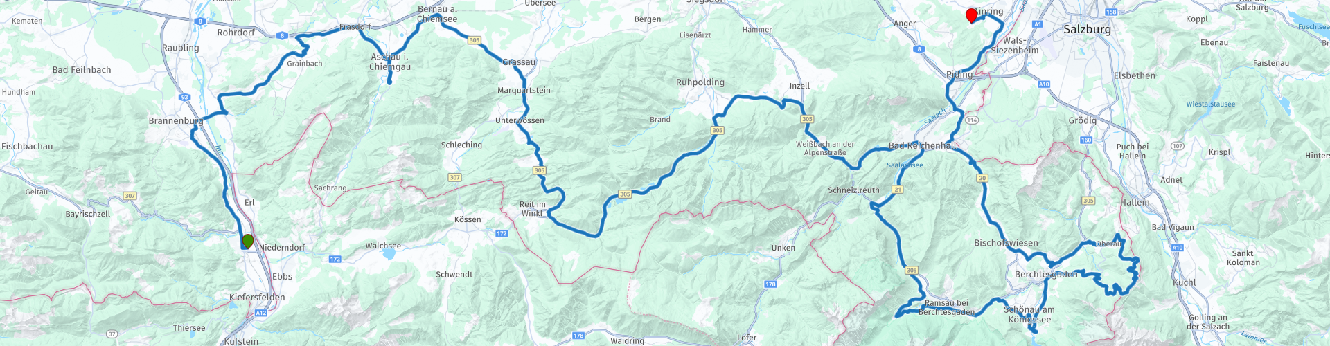
Oberaudorf to Ainring

This route was brought to you by:
RouteXpert Marcel Scherpenkate
Last edit: 13-04-2021
 Route Summary
 The route has been equalized for TomTom, Garmin and MyRoute-app Navigation users.
I rate this route with the maximum number of 5 stars, I have been allowed to drive this route myself and it is a succession of diversity of landscape via beautiful roads connected by equally authentic villages and panoramic views. Wonderful to drive through.
 Share this route


Animation

Verdict


Duration
6h 32m

Mode of travel
Car or motorcycle

Distance
208.37 km

Countries


 RouteXpert Review
 A tributary of the Danube and one of the main drainage routes of the Alps, the Inn is 517 km long and flows through three countries: Switzerland, Austria and Germany. Before it finally reaches the Black Sea, it flows through nine countries. No other river flows through so many European countries.
You cross the Autobahn and the Inn and drive through beautiful foothills of the Alps in the direction of Aschau am Chiemsee with a panoramic view of the Kampenwand from 1668 meters high.
The Kampenwand near Aschau is one of the best known and at the same time most popular peaks in the Chiemgau Alps and, with its jagged ridge, a landmark of the region.
The whimsical nut is reminiscent of a rooster's head. The summit cross (also called Chiemgaukreuz) on the east summit is the highest mountain cross in the Bavarian Alps with a height of 12 meters.
If you would like to admire this beautiful area from above, there is a cable car, the Kampenwandbahn, here you will be taken from 626 m to 1467 meters high in 14 minutes.
The route continues through a landscape with meadows and forests. The Salz & Moor museum is located between Rottau and Grassau. Here you can learn all about the 'world's first pipeline', a brine pipeline, which transported salt from the mines in the Berchtesgaden area to Rosenheim.
The Mohr part tells the history of living and life in the high moor. Due to the silting up of the Chiemsee, this unique landscape is called Kendlmuhlfilzen. Due to the large number of dead plants, a thick layer of peat was formed here, which was industrially extracted until the 1980s. The area was declared a nature reserve in 1992.
In Grassau you follow the Tiroler Ache river south to Marquartstein. After the villages of Unter- und Oberwössen the route only goes in one direction and that is uphill. For 6.5 km, it goes up to the Masereralm with an ascent of 12%. Along the way you have a beautiful view over the landscape far beyond the borders of the Chiemgau region.
You drive past Reit im Winkl in fact the southernmost corner of Germany.
The route then goes through a natural landscape typical of the Alps to the Three Lakes region. You pass the Weitsee, the Mittersee and the Lödensee. After these 3 lakes, the Zirnberg Alm looms on the right, where you can stretch your legs and have a cup of coffee.
After the stop you drive into the Berchtesgadener Land, an area with legendary mountains, rolling hills, and idyllic pastures. The untouched nature of 'National Park Berchtesgaden' and the panoramic views will stay with you for a long time. You drive on the Alpenstrasse through the beautiful landscape of the Berchtesgadener Alps towards Bad Reichenhall and over the 868 meter high Schwarzbachwacht. Here you can look for the first time at the Hochkalter 2,608 meters and the Watzmann at 2,713 meters.
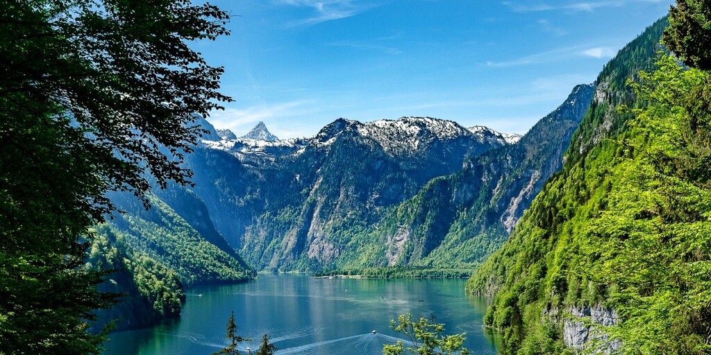
Please note, just over the top you quickly turn right into Alte Reichenallerstrasse. Here you can encounter stray cattle in the alpine pasture, so watch out again. You will pass the Hintersee, a very busy tourist spot on the lake, with really only restaurants. Eventually you will arrive at the Königssee, a lake on the border with Austria. It is the deepest lake in Germany with a depth of up to 190 m. Most of the lake is located in the Berchtesgaden National Park.
At the Königssee you have the opportunity to stop and have lunch before driving the last part of this route on the Rossfeld panoramastrasse.
The Rossfeld panoramastrasse is not only the highest one, but also one of the most famous toll roads in Germany. You drive through the beautiful Berchtesgadener Alps where you also drive partly through Austria. The Rossfeldstrasse is over 15 kilometers long and the top is at an altitude of 1540 meters.
As mentioned, you can enjoy the beautiful panoramic view in good weather, you can see Salzburg as well as Berchtesgaden and the Austrian Alps. There are plenty of places where you can put the engine aside to enjoy and take a picture. On the way you can visit the Dokumentation Obersalzberg. This is a museum of learning and remembrance. At this historic location you are offered the opportunity to take in the history of the Obersalzberg and that of National Socialism. There is also the possibility to visit the Kehlsteinhaus, also known as the Eagle's Nest. It is built on top of the Kehlstein.
The house has been in use as a mountain restaurant since 1952 and access is only possible with the special Kehlstein Line buses. These take you to a parking lot from where you make the final climb up through a tunnel and an elevator.
At an altitude of 1,834 meters, in clear weather and in noticeably pure mountain air, you even have a view of the imposing Hochkönig with its 2,941 meters.
After enjoying the beautiful views of the Obersalzberg you drive via Berchtesgaden to Ainring.
Here you can spend the night in Hotel De Reiteralm.

 Links
Links  Usage
Usage Want to download this route?
You can download the route for free without MyRoute-app account. To do so, open the route and click 'save as'. Want to edit this route?
No problem, start by opening the route. Follow the tutorial and create your personal MyRoute-app account. After registration, your trial starts automatically.  Disclaimer
Use of this GPS route is at your own expense and risk. The route has been carefully composed and checked by a MyRoute-app accredited RouteXpert for use on TomTom, Garmin and MyRoute-app Navigation.
Changes may nevertheless have occurred due to changed circumstances, road diversions or seasonal closures. We therefore recommend checking each route before use.
Preferably use the route track in your navigation system. More information about the use of MyRoute-app can be found on the website under 'Community' or 'Academy'.

Salzburg
About this region
Salzburg (Austrian German: [ˈsaltsbʊʁk], German: [ˈzaltsbʊʁk] (listen); literally "Salt Fortress"; Austro-Bavarian: Soizbuag) is the fourth-largest city in Austria. In 2020, it had a population of 156,872.The town is on the site of the Roman settlement of Iuvavum. Salzburg was founded as an episcopal see in 696 and became a seat of the archbishop in 798. Its main sources of income were salt extraction, trade and gold mining. The fortress of Hohensalzburg, one of the largest medieval fortresses in Europe, dates from the 11th century. In the 17th century, Salzburg became a centre of the Counter-Reformation, with monasteries and numerous Baroque churches built.
Salzburg's historic centre (German: Altstadt) is renowned for its Baroque architecture and is one of the best-preserved city centres north of the Alps. The historic center was enlisted as a UNESCO World Heritage Site in 1996. The city has three universities and a large population of students. Tourists also visit Salzburg to tour the historic centre and the scenic Alpine surroundings. Salzburg was the birthplace of the 18th-century composer Wolfgang Amadeus Mozart.
Read more on Wikipedia
Salzburg's historic centre (German: Altstadt) is renowned for its Baroque architecture and is one of the best-preserved city centres north of the Alps. The historic center was enlisted as a UNESCO World Heritage Site in 1996. The city has three universities and a large population of students. Tourists also visit Salzburg to tour the historic centre and the scenic Alpine surroundings. Salzburg was the birthplace of the 18th-century composer Wolfgang Amadeus Mozart.
View region
 Statistics
  13
13Amount of RX reviews (Salzburg)
 14650
14650Amount of visitors (Salzburg)
 1694
1694Amount of downloads (Salzburg)
 Route Collections in this region
 The 24 Most Beautiful Alpine Routes
The Alps, The Alps are a mountain range in Europe, stretching from the French Mediterranean coast in the southwest to the Pannonian Plain in the east. The area of the mountain range is more than 200,000 km².
In other words Passes and Mountain Roads!
Driving through the mountains is great! Especially over the mountain passes with hairpin bends and narrow winding roads. Every bend a different view where you can enjoy. There are many beautiful mountain passes in the Alps.
A selection that has also been incorporated into these routes:
The Stlevio Pass:
The Stelvio Pass, also known as Passo dello Stelvio, is mainly known for the stage in the Giro d'Italia. Due to the length and the difference in height, this pass is seen as one of the toughest tests in cycling. The Stelvio Pass reaches a maximum height of 2758 meters and is therefore one of the highest in the Alps. The pass connects the towns of Bormio and Prato Allo Stelvio. In winter the pass is closed due to heavy snowfall.
The Reschenpass:
The Reschenpass, also known as Passo di Resia, connects the Austrian state of Tyrol with the Italian province of South Tyrol. The pass reaches a maximum height of 1,504 meters and has been one of the most important north-south connections in the Alps in recent centuries. The pass was used long before Roman times. Along the way you will pass several highlights and historical relics. One of the highlights is the Reschensee. This lake was created after the construction of the dam and has completely submerged the village of Graun. The only thing that reminds of that is the clock tower in the middle of the lake.
Col du Galibier:
The French mountain pass Col du Galibier connects the towns of Saint-Michel-de-Maurienne and Briançon via the Col du Lautaret in the south and the Col du Télégraphe in the north. The mountain pass is part of the Tour de France and very much feared, due to the fact that it can only be reached via the other two mountain passes. The pass reaches a maximum height of 2646 meters. From there you can take a walk to the viewpoint at 2704 meters. You can admire the peaks of the Grand Galibier, Mont Blanc and La Meije here.
The Grossglockner High Alpine Road:
With a height of 3798 meters the Grossglockner is the highest mountain in Austria. To fully enjoy this impressive mountain, you can drive over the Grossglockner High Alpine Road and the accompanying pass. The route starts from Bruck am Grossglockner and ends in Heiligenblut. Of course you can drive in two directions. The pass reaches a maximum height of 2504 meters and is closed in winter due to heavy snowfall. Along the way you pass several stops with fun activities, information points, mountain huts and viewpoints. A visit to the Kaiser-Franz-Josefs-Höhe and Pasterzen Glacier is highly recommended.
The Col d'Izoard:
Just like the Col du Galibier, the Col d'Izoard is also part of a stage of the Tour de France. The mountain pass connects Briançon with the valley of the river Guil. The pass is partly located in the Regional Natural Park du Queyras and reaches a maximum height of 2360 meters. What is special about the Col d'Izoard is the barren and rocky landscape. Sometimes it feels like driving a car over the moon! Along the way you can stop at several points to enjoy the beautiful view.
The Bernina Pass:
The Bernina Express is one of the most famous rail trains in Switzerland and the Alps. The route is beautiful and partly included on the UNESCO World Heritage List. Parallel to the railway lies the Bernina pass, which connects the Veltlin valley with the Egandin valley. This beautiful Alpine road has a total length of 56 kilometers and reaches a maximum height of 2328 meters. Along the way you can enjoy views of the Morteratsch Glacier.
The Sella Pass:
The Sella Pass, also known as Passo di Sella, takes you over one of the most impressive mountain ranges in the Dolomites: the Sella massif. The pass connects Valle di Fassa with Val Gardena and reaches a maximum height of 2236 meters. At this height is also the border of the Italian provinces of Trentino and Bolzano. Along the way you can enjoy the view of this spectacular mountain world. Admire, for example, the three peaks of the Sasso Lungo massif, the Sella massif or the peaks of the Marmolada. You can also drive the Sella pass in combination with the Gardena pass, Pordoi pass and Campolongo pass.
The Grimsel Pass:
The Grimsel Pass connects Goms in Wallis with the Halis Valley in the Bernese Oberland. The pass reaches a maximum elevation of 2165 meters and is closed in winter due to snowfall. Over the centuries, the mountain pass has played an important role in trade between Switzerland and Italy. Now it is mainly the reservoirs that have an important function. These are used to generate electricity. The landscape you drive through is rugged, rocky and impressive. On top of the pass is a hotel and a restaurant with a special marmot park. The Dodensee (Totensee) is also located here. This lake owes its name to the many soldiers who died in the time of Napoleon.
The Gotthard Pass:
The Gotthard Pass, also known as Passo del San Gottardo and Saint Gotthard, connects the Swiss towns of Airolo and Andermatt. The mountain pass and associated tunnel are especially known among holidaymakers driving from Switzerland to Italy. But where the majority opt for the tunnel, it is precisely the pass that really completes the holiday. The Gotthard Pass has a length of about 26 kilometers and reaches a maximum height of 2106 meters. The route is beautiful and takes you along old villages and beautiful views.
The Silvretta High Alpine Road and Silvretta Pass:
The Paznaun Valley in Tyrol and the Montafon in Vorarlberg are connected by the Silvretta High Alpine Road. The route has a length of 22.3 kilometers and leads from Galtür to Partenen in 34 hairpin bends, via the 2032 meter high Bielerhöhe. The Silvrettasee is also located at this point, where you can enjoy a lovely walk. The pass is closed in winter due to snowfall.
The Simplon Pass:
Just like the Gotthard Pass, many holidaymakers also travel over the Simplon Pass every year. This mountain pass connects the Rhone Valley in the canton of Valais with the Valle d'Ossola in Piemonte. The pass is open all year round and reaches a maximum height of 2005 meters. Along the way you pass a number of buildings, including the well-known Simplon Hospiz from 1825. The hospiz is managed by the monks of St. Bernard. From the highest point on the pass, all kinds of hiking routes are possible and you will also come across a hotel where you can spend the night.
The Gerlos Pass:
The Gerlos Pass connects the Salzach Valley in the Salzburgerland with the Zillertal Valley in Tyrol. The pass is part of the Gerlos Alpenstraße and runs right through the Hohe Tauern National Park. Along the way you can enjoy beautiful views of the surroundings. The pass has a length of 12 kilometers and reaches a maximum height of 1531 meters. A ride over the Gerlos Pass can be ideally combined with a visit to the Krimmler Wasserfälle.
The Great St. Bernard Pass:
The Great St. Bernard Pass, better known as Col du Grand Saint Bernard, connects the Italian province of Valle d'Aosta with the Swiss canton of Valais. The pass is one of the highest in Switzerland and reaches a maximum height of 2469 meters. Like a number of other mountain passes in this list, the Great St. Bernard Pass has also been used as a connecting road for centuries. The pass is named after the St. Bernard dogs that used to help stranded travelers along with the monks. The pass is closed in winter.
The Timmelsjoch High Alpine Road:
The Timmelsjoch High Alpine Road connects the towns of Sölden in the Ötztal and Meran in South Tyrol. Tolls must be paid on the Hochgurgl - Moos route. Via a mountain road with about 60 hairpin bends you drive through a beautiful mountain world. With the Timmelsjoch Experience you can learn more about the history, the road and the environment via various stations. You can also visit the Top Mountain Crosspoint museum.
Col de l'Iseran:
With a maximum pass height of 2770 meters, the Col l'Iséran is one of the highest mountain passes in the Alps. The pass connects Bourg-Saint-Maurice with Bonneval-sur-Arc. Via a road full of hairpin bends you pass, among other things, Val-d'Isère and a side valley of the Maurienne that lies entirely in the National Park de la Vanoise. You can spot animals such as marmots and chamois and there is also a restaurant with a chapel on top of the pass.
The Gavia Pass:
The Gavia Pass (Italian Passo di Gavia) is a mountain pass in the Italian Alps, in the Lombardy region.
It is one of the highest pass roads in Europe. The road leads through the unspoilt Stelvio National Park. The road was built in the First World War to supply Italian soldiers who fought in the Italian-Austrian border area. The pass height is one of the most beautiful in the Alps. Here is the large Lago Bianco with, to the north, the mountain San Matteo (3684 meters). Lago Nero is slightly lower on the south side of the pass. Here the mountain group of the Adamello determines the view. There are many well-marked walks in the area. During the winter the pass is closed due to the heavy snowfall. The pass is often closed until May and June due to the large amount of snow.
Promoter has made a selection of the 24 Most Beautiful Alpine routes that they have set out in recent years.
The routes go through:
France
Austria
Switzerland
Italy
The most beautiful roads, the most beautiful views, the most beautiful viewpoints. The highest mountains, the fastest descents, hairpin bend after hairpin bend, you name it you can't get enough of it.
If you go on holiday in this region, take advantage of it, ALL routes in this collection have been checked and made equal for TomTom, Garmin and MyRoute-app Navigation by a MyRoute-app RouteXpert.
Have fun with this collection and while driving one of these routes. Enjoy all the beauty that the Alps and the Dolomites have to offer. Click on “View route” to read the review of the chosen route.
I would like to hear your findings about the route(s).
View Route Collection
The 12 most beautiful car and motorcycle routes in Carinthia
“Motorradland Kärnten” where you feel so wonderfully welcome as a motorcyclist!
Own website for motorcyclists, own curated routes, hotels, campsites and guest houses with attention for motorcyclists, a wonderful area where motorcyclists are very popular.
Kärnten or Carinthia, at the crossroads of the Germanic, Slavic and Roman worlds. Three cultures within a few kilometres, southern flair, culinary delights, cross-border tours. Breakfast in Italy, lunch in Slovenia, dinner in Austria - all in one day. Experience the diversity in the borderless Alps-Adriatic region, the area for motorcyclists.
Extensive day trips on winding mountain paths, romantic panoramic routes and beautiful lakes, here the 12 TOP routes Kärnten / Carinthia. Enjoy!
View Route Collection