R09 QLD Brisbane to Chinchilla

This route was brought to you by:
RouteXpert Hans van de Ven (Mr.MRA)
Last edit: 15-03-2020
 Route Summary
 Australia is very large; 8 million km2, which is more than 226 times larger than the Netherlands! Has a diversity of flora and fauna; the most diverse types of plants, trees and animals, especially birds and many typical Australian marsupials, which you will not find anywhere else in the world!
Enjoy all the beauty: From the evergreen tropical rainforests to the vast Outback; from the desert to the countless and peaceful idyllic palm beaches; from the winter sports areas in the southeast to the vibrant and impressive metropolis of Melbourne, Sydney and Perth.
You will see it all and experience it in this amazing tour through Australia, a tour to remember!
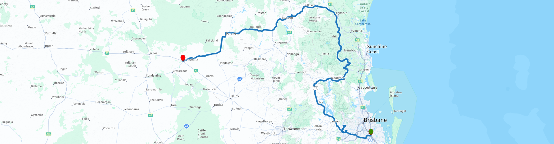
Starting point: Brisbane, Hotel Gloria Springwood
End Point: Chinchilla, Downtown Motor Inn
The route has been created for TomTom, Garmin and MyRoute-app Navigation users.
ATTENTION: DRIVE LEFT!
 Share this route


Animation

Verdict


Duration
7h 52m

Mode of travel
Car or motorcycle

Distance
602.23 km

Countries

 RouteXpert Review
 This route takes you to Chinchilla, which is a town in the Western Downs region. At the 2016 census, Chinchilla had a population of 6,612. The city (about 300 kilometers west of northwest Brisbane) was founded in 1877. As the railroad ran west from Toowoomba and Dalby across the Darling Downs, a temporary construction camp was established on the banks of Charley's Creek that grew into this town. Agriculture is the mainstay of the community, with beef, pork, wool production and horticulture production. Known as the 'Melon Capital of Australia', Chinchilla hosts a melon festival every two years in February - the next one being held in 2021.
You leave Brisbane via the highway, to leave it after about 40 KM to stop at the supermarket to do some shopping, so that you have something to eat and drink with you on the way. Via a beautiful through road and an equally beautiful "green" environment, you arrive in the town of Fernvale. This is a small town and you can stop by the Subway for a coffee. Soon after coffee you will pass Lake Wivenhoe, this dam is the largest water storage in South East Queensland and is the main water supply for Brisbane and the greater Ipswich area. Wivenhoe Dam was built on the Brisbane River. It was designed by the Water Resources Commission and built in 1984. The dam was built with the dual purpose of providing a safe and reliable water supply for the region and limiting flooding. Wivenhoe Dam has a total storage capacity of 3,132 million megaliths.
Further in the town of Kilcoy, after about 180 KM, there is a possibility to refuel. You can have lunch in the town of Maleny at "Brouhaha Brewery and Restaurant", you are almost halfway through the route. After lunch you go to "Gympie". Originally, this area was intended for grazing livestock. Until James Nash discovered gold in the area in 1867. At the time, Queensland was in economic depression and this discovery saved it from destruction. The search for gold still plays a role in the economy of Gympie, besides agriculture (with especially milk production), labor and tourism are important sources of income. Gympie's name comes from the Aboriginal name for a tree (the Gympie gympie tree). The tree has large round leaves that have the same properties as those of nettles. The translation for Gympie is roughly “devil”.
The main attractions of Gympie are:
1. “The Valley Rattler” is a steam train that allows you to view the landscape around Gympie. It starts on the south side of Gympie, then continues through the Mary Valley where it follows the Mary River. This ride is a journey across the valley starting at the old Gympie train station. This station is the original station of the track that ran through Gympie during the gold rush of 1900.
2. Pineapples, macadamia nuts and other crops grow on the hilly landscape around Gympie. In addition, it is a beautiful landscape through the vast forests. The villages Dagun, Amamoor, Kandanga and Imbil are also located in this valley.
3. Mary Street is the center, here is the post office, all kinds of bars, cafes, banks and shops. It has real village appearance.
4. Every year a large music event is organized in Gympie, attracting thousands of fans and musicians.
After leaving Gympie, you will drive through a beautiful varied environment, then through forests, then past meadows and you will pass through the following towns: Kilkivan, Murgon (here you also have the option to refuel), Wondai & Kingaroy in Chinchilla at the end point.
This 4-star rated route goes the first stretch over the highway and then through roads through nature reserves and some nice places where you can stop for a snack or refuel.
General info:
Queensland (literally translated: Queensland) is a state in northeastern Australia. Queensland is the second largest in area and Australia's third largest state in terms of population. The state was named after Queen Victoria, the monarch at the time of the settlement of the former colony. The capital and largest city of Queensland is Brisbane, located in the southeast of the state. The northern portion of the state, separated by the Tropic of Capricorn, is tropical. The south is subtropical. Queensland was originally a British crown colony that emerged in 1859 after secession from New South Wales. The city of Brisbane originally started out as the Moreton Bay penal colony, which held convicts who again committed errors while serving their sentences in New South Wales.
Brisbane is located about 100 kilometers north of the border between Queensland and New South Wales. Southeast Queensland also has two larger population centers: the Gold Coast south of Brisbane, and the Sunshine Coast north of Brisbane. Along the approx. 2000 km long coast (from south to north) are the following cities: Coolangatta - Gold Coast - Brisbane - Sunshine Coast - Gympie - Maryborough - Hervey Bay - Bundaberg - Gladstone - Rockhampton - Mackay - Townsville - Cairns. The following cities are inland (counterclockwise): Warwick - Toowoomba - Roma - Charters Towers - Mount Isa. The world's largest city by surface, Mount Isa is located in northwestern Queensland. The area of the city is 42,904 km² (approximately the area of the Netherlands!), But the city has a population of approximately 20,000 (2003).
The state is home to five World Heritage Sites: Australian Mammal Fossil Sites (Riversleigh / Naracoorte),
Gondwana rainforests, Fraser Island, The Great Barrier Reef and the Tropical wetlands of Queensland.
Queensland can be roughly divided into three parts:
1.The eastern coastal strip, dominated by the Great Australian Separation Mountains. From north to south there are also the Darling Downs, the Bunya Mountains, the Carnarvon Gorge, the Whitsunday Islands, Hinchinbrook Island and the Atherton Tableland. Off the coast, north of Fraser Island, the Great Barrier Reef begins.
2.The tropical Cape York Peninsula in the north. To the north of this is the Straits Torres with the Straits Torres Islands and to the east most of the Great Barrier Reef.
3 Most of the dry interior, called the Queensland outback, with the Channel Country in the southwest.


 Links
Links  Usage
Usage Want to download this route?
You can download the route for free without MyRoute-app account. To do so, open the route and click 'save as'. Want to edit this route?
No problem, start by opening the route. Follow the tutorial and create your personal MyRoute-app account. After registration, your trial starts automatically.  Disclaimer
Use of this GPS route is at your own expense and risk. The route has been carefully composed and checked by a MyRoute-app accredited RouteXpert for use on TomTom, Garmin and MyRoute-app Navigation.
Changes may nevertheless have occurred due to changed circumstances, road diversions or seasonal closures. We therefore recommend checking each route before use.
Preferably use the route track in your navigation system. More information about the use of MyRoute-app can be found on the website under 'Community' or 'Academy'.