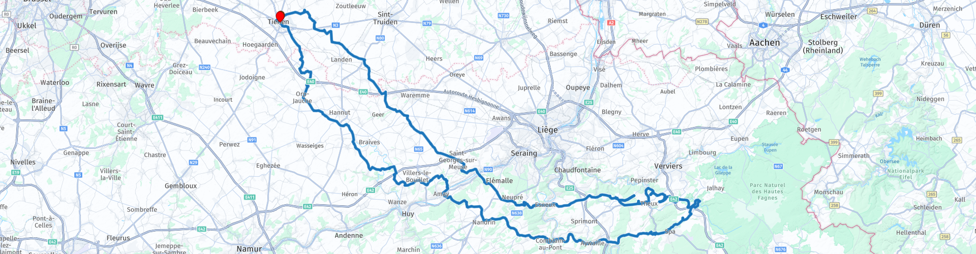
Rondrit naar de Royompre waterval vanuit Tienen

This route was brought to you by:
RouteXpert Guy Heyns - Adv. RouteXpert
Last edit: 10-12-2024
 Route Summary
 On the return trip you will also pass some famous places such as Spa and cross important rivers such as the Ourthe, the Amblève and the Maas.
Long rolling roads and fun exciting curves become your part on this route that you can crown - if you are lucky - with a beautiful photo of your steel steed on top of the Royompré waterfall.
 Share this route


Animation

Verdict


Duration
5h 56m

Mode of travel
Car or motorcycle

Distance
229.29 km

Countries

 RouteXpert Review
 After the waterfall, the route offers you good roads with long and fast bends and the weather is fully enjoyed in a different way while you pass famous places.
The route starts and stops in Tienen, the 'sugar city'. Everything around Tienen is therefore dominated by this 'addictive' substance that so many enjoy. You drive on the last part of the route past the factory and you can visit the sugar museum in the center if you wish.
The first part takes you through the typical Flemish agricultural landscape to the crossing over the Maas (rp19). The Maas is a 925 km long river that finds its source in France and eventually runs into the sea in the Netherlands. However, not without first creating a beautiful landscape along its banks. You will also notice this during this route where you also come along the main tributaries of the Meuse (Amblève (rp 40) and Ourthe (rp 21 & 42).
You can make a first stop in Esneux, along the Ourthe river (rp 20). Café BelleVue indeed offers you what it promises… a magnificent view of not only the Ourthe, but also of Chateau 'Le Fy', a fairytale castle, completely restored by a Dutch millionaire broker, that is proudly displayed on top of the hill . Unfortunately not to visit but the view alone will take your breath away, and certainly when you realize that it is private property. From a king then….
Between route points 26 and 30 you should not only pay attention to the beautiful surroundings, but also pay attention to the road. This section is very narrow and (in 2020) the road quality was rather 'challenging'. If desired, a first alternative can be found via the more northerly located Pepinster and Ensival and then drive back south to the route. A second alternative is to reconnect with the route thv rp30 in Banneux (just after rp24) via Theux, Marché and Sassor.
Finally, you will arrive at rp 34 at the destination of the trip, the Royompré waterfall in Jalhay. This waterfall was created when the road that the Hoëgne ran over was concreted. This created a unique, particularly photogenic location; after all, it is not always possible to just stand on top of a waterfall with a vehicle… It is possible here.
Unfortunately, the location is already shared too much and this does not always attract equally respectful people. The locals thus see with regret that 'strangers' here try to take the umpteenth shot of their vehicle with a lot of noise and display while the water splashes in all directions. Moreover, the bridge leads to a field where camps are set up in the summer and these youth movements are not always charmed by reckless drivers who do not treat the location with the necessary respect.
The best time to visit this location is therefore out of season and preferably not on a sunny weekend day when the nearby (and usually quiet) beach is used by the locals to relax. But if you treat both the local people and the environment with respect, you will certainly be given that one photo opportunity that you can look back on with pride.
Mind you, there is not (yet) a cafe or other place in the short vicinity of the waterfall. There is a picnic area, so if you bring your own picnic, you can enjoy the location directly from the parking / beach.
The town of Spa is located about ten kilometers after the Royompré waterfall. Where the world famous bottled water comes from. The route turns in Spa itself to the right and away from the busy center, but at rp 37 you can make a stop if desired and without obligation by turning left. You can drink or eat in one of the many occasions, visit one of the sources or even take a gamble in the casino if you happen to have a tuxedo in your top case.
Just after Spa you will pass a selection of petrol stations. These are the last ones on the route itself, so if necessary, you can also quench the thirst of your courageous steed.
The route then leads you through fun, sometimes surprising roads to Rémouchamps. If it is too busy in Spa (chances are very high) then Rémouchamps 13 kilometers away is an excellent and slightly quieter alternative. For example, an artisan ice cream on the banks of the Amblève tastes particularly good in Rémouchamps (rp 39), especially after a visit to the caves of Rémouchamps where you can take the longest underground boat trip in the world (700 meters).
If you continue the route you will pass the Ourthe for the second time on rp 42, as well as the Amblève and the Meuse, a lifeline for tourist Wallonia. You drive along the Ourthe for a moment and then pass a number of brightly curved bends and nice long roads under the wheels.
When you pass the Maas again at rp 46, it is time to look up a terrace at rp 47 'Le Tambour'. Pleasant terrace, spacious parking and last stop on the route.
You will notice it when you approach Tienen back. The landscape area disappears and suddenly you find yourself in an environment that clearly radiates industrialization, also in residential construction. Shortly afterwards you will pass the Tiense sugar factory (rp 63) on the Tiense ring.
In the center of Tienen you can easily find an opportunity to end the ride with a snack and / or a drink and, if desired, you can also visit the sugar museum on the market.
The ride deserves 4 stars for me. If the poor road quality didn't throw a spanner in the works between points 26 and 30, the route would have definitely been worth 5 stars. The Royompré waterfall location (rp34) is beautiful, the places you drive through are even famous (Spa rp37) and some views are breathtaking (Castle Le Fy rp 21). But also the roads to and from the Royompré waterfall are great fun, offer more than enough variety and outside the nice technical bends you will also find wonderfully elongated stretches where that 'motorbike feeling' completely captures you.
You will therefore be able to look back on a pleasant ride on the Tienen market and - who knows - also on a beautiful photo taken at the Royompré waterfall.


 Links
Links  Usage
Usage Want to download this route?
You can download the route for free without MyRoute-app account. To do so, open the route and click 'save as'. Want to edit this route?
No problem, start by opening the route. Follow the tutorial and create your personal MyRoute-app account. After registration, your trial starts automatically.  Disclaimer
Use of this GPS route is at your own expense and risk. The route has been carefully composed and checked by a MyRoute-app accredited RouteXpert for use on TomTom, Garmin and MyRoute-app Navigation.
Changes may nevertheless have occurred due to changed circumstances, road diversions or seasonal closures. We therefore recommend checking each route before use.
Preferably use the route track in your navigation system. More information about the use of MyRoute-app can be found on the website under 'Community' or 'Academy'.

Wallonia
About this region
The Walloon Region (French: Région wallonne [ʁeʒjɔ̃ walɔn]; German: Wallonische Region; Dutch: Waals gewest), usually simply referred to as Wallonia (; French: Wallonie [walɔni]; Walloon: Waloneye; German: Wallonien [vaˈloːni̯ən] (listen) or Wallonie [valoˈniː]; Dutch: Wallonië [ʋɑˈloːnijə] (listen)), is one of the three Regions of Belgium—alongside the Flemish Region and the Brussels-Capital Region.Covering the southern portion of the country, Wallonia is primarily French-speaking, and accounts for 55% of Belgium's territory, but only a third of its population. The Walloon Region was not merged with the French Community of Belgium, which is the political entity responsible for matters related mainly to culture and education, because the French Community of Belgium encompasses both Wallonia and the bilingual Brussels-Capital Region.
There is a German-speaking minority in eastern Wallonia, resulting from the annexation of three cantons previously part of the German Empire at the conclusion of World War I. This community represents less than 1% of the Belgian population. It forms the German-speaking Community of Belgium, which has its own government and parliament for culture-related issues.
During the industrial revolution, Wallonia was second only to the United Kingdom in industrialization, capitalizing on its extensive deposits of coal and iron. This brought the region wealth, and from the beginning of the 19th to the middle of the 20th century, Wallonia was the more prosperous half of Belgium. Since World War II, the importance of heavy industry has greatly diminished, and the Flemish Region has exceeded Wallonia in wealth as Wallonia has declined economically. Wallonia now suffers from high unemployment and has a significantly lower GDP per capita than Flanders. The economic inequalities and linguistic divide between the two are major sources of political conflicts in Belgium and a major factor in Flemish separatism.
The capital of Wallonia is Namur, and the most populous city is Charleroi. Most of Wallonia's major cities and two-thirds of its population lie along the east-west aligned Sambre and Meuse valley, the former industrial backbone of Belgium. To the north of this valley, Wallonia lies on the Central Belgian Plateau, which, like Flanders, is a relatively flat and agriculturally fertile area. The south and southeast of Wallonia is made up of the Ardennes, an expanse of forested highland that is less densely populated.
Wallonia borders Flanders and the Netherlands (the province of Limburg) in the north, France (Grand Est and Hauts-de-France) to the south and west, and Germany (North Rhine-Westphalia and Rhineland-Palatinate) and Luxembourg (Capellen, Clervaux, Esch-sur-Alzette, Redange and Wiltz) to the east. Wallonia has been a member of the Organisation Internationale de la Francophonie since 1980.
Read more on Wikipedia
There is a German-speaking minority in eastern Wallonia, resulting from the annexation of three cantons previously part of the German Empire at the conclusion of World War I. This community represents less than 1% of the Belgian population. It forms the German-speaking Community of Belgium, which has its own government and parliament for culture-related issues.
During the industrial revolution, Wallonia was second only to the United Kingdom in industrialization, capitalizing on its extensive deposits of coal and iron. This brought the region wealth, and from the beginning of the 19th to the middle of the 20th century, Wallonia was the more prosperous half of Belgium. Since World War II, the importance of heavy industry has greatly diminished, and the Flemish Region has exceeded Wallonia in wealth as Wallonia has declined economically. Wallonia now suffers from high unemployment and has a significantly lower GDP per capita than Flanders. The economic inequalities and linguistic divide between the two are major sources of political conflicts in Belgium and a major factor in Flemish separatism.
The capital of Wallonia is Namur, and the most populous city is Charleroi. Most of Wallonia's major cities and two-thirds of its population lie along the east-west aligned Sambre and Meuse valley, the former industrial backbone of Belgium. To the north of this valley, Wallonia lies on the Central Belgian Plateau, which, like Flanders, is a relatively flat and agriculturally fertile area. The south and southeast of Wallonia is made up of the Ardennes, an expanse of forested highland that is less densely populated.
Wallonia borders Flanders and the Netherlands (the province of Limburg) in the north, France (Grand Est and Hauts-de-France) to the south and west, and Germany (North Rhine-Westphalia and Rhineland-Palatinate) and Luxembourg (Capellen, Clervaux, Esch-sur-Alzette, Redange and Wiltz) to the east. Wallonia has been a member of the Organisation Internationale de la Francophonie since 1980.
View region
 Statistics
  99
99Amount of RX reviews (Wallonia)
 27296
27296Amount of visitors (Wallonia)
 22572
22572Amount of downloads (Wallonia)
 Route Collections in this region
 The 10 most beautiful car and motorcycle routes in Limburg
Limburg, who thinks of Limburg, thinks of flan, coal mines, marl and the hill country. The coal mines have been closed for almost 40 years, the last load of coal was brought up from the Oranje-Nassau coal mine in Heerlen on 31 December and, as they say, South Limburg was transformed from Black to Green and unfortunately there is still little left. view of this period.
But not only pie, marl and coal in Limburg, but also a very beautiful province to tour by car or motorcycle and enjoy all the beauty that the province of Limburg has to offer. For this, the MyRoute app RouteXpert has put together a Top 10 of Car and Motorcycle routes for you.
All routes in this collection have been checked and made equal for TomTom, Garmin and MyRoute-app Navigation by a MyRoute-app RouteXpert.
If you think, I have a very nice route that should certainly not be missing from this collection, send it to:
email: routeexpert@myrouteapp.com
Subject: New Route for the Top 10 collection Province of Limburg composed by Hans van de Ven.
The route will then be reviewed and then added to the Top 10.
To make the Top 10 also the Top 10, 1 route will have to disappear from the Top 10, you can indicate this when submitting the new route.
Have fun with this collection and while driving one of these routes. Enjoy all the beauty that the Netherlands and in particular the province of Limburg has to offer. Click on “View route” to read the review of the chosen route.
I would like to hear your findings about the route(s).
View Route Collection
Top 5 Car and Motorcycle Routes in the Eifel
The Eifel is the eastern part of the medium plateau Eifel-Ardennes. It is located north of the Moselle and west of the Rhine. The largest part is in Germany, a small part is in Belgium, in the East Cantons. The German part of Eifel is located in the federal states of North Rhine-Westphalia and Rhineland-Palatinate. The highest point is the Hohe Acht with 747 meters.
Several chains can be distinguished in the Eifel:
The northernmost part is called the Nordeifel, which in Belgium connects to the High Fens;
To the east of this is the Ahrgebirge, this part is located north of the Ahr in the Ahrweiler district;
South of the Ahr is the Hohe Eifel (or Hocheifel), of which the Hohe Acht (747 m) is the highest point, and also the highest point in the entire Eifel region;
To the west, near the Belgian border, the hills are known as Schneifel, part of the wider Snow Eifel area with peaks reaching up to 698 metres;
South and east of the Hohe Eifel is the Volcano-Eifel, a volcanic area with many crater lakes (Maare).
The southern part of the Eifel is less high. The area is bisected by streams and rivers running southwards. These streams flow into the Moselle. The largest of these rivers is the Kyll; the hills around this river are known as the Kyllwald;
In the south, the Eifel ends in the Voreifel.
In the north of the Eifel there are some large reservoirs. The largest of these is the reservoir in the Roer that was created by the construction of the Roerdal dam.
The Nürburgring is also located in the Eifel, a well-known car circuit for Formula 1 races, among other things. Since 2004, part of the north of the Eifel has become the Eifel National Park. This National Park falls entirely within the German-Belgian nature park High Fens-Eifel. Another part of the Eifel falls within the South Eifel Nature Park.
Well-known throughout the Netherlands and Belgium by car and motorcyclists, so reason enough for the MyRoute app RouteXpert to compile a Top 5 of Car and Motorbike routes for you.
All routes in this collection have been checked and made equal for TomTom, Garmin and MyRoute-app Navigation by a MyRoute-app RouteXpert.
If you think, I have a very nice route that should certainly not be missing from this collection, send it to:
email: routeexpert@myrouteapp.com
Subject: New Route for the Top 5 collection Eifel composed by Hans van de Ven.
The route will then be reviewed and then added to the Top 5. To make the Top 5 also the Top 5, 1 route will have to disappear from the Top 5, you can indicate this when submitting the new route.
Have fun with this collection and while driving one of these routes. Enjoy all the beauty that the Eifel has to offer. Click on “View route” to read the review of the chosen route.
I would like to hear your findings about the route(s).
View Route Collection