Day 07 TCH Calgary to Medicine Hat

This route was brought to you by:
RouteXpert René Plücken (MRA Master)
Last edit: 12-02-2021
 Route Summary
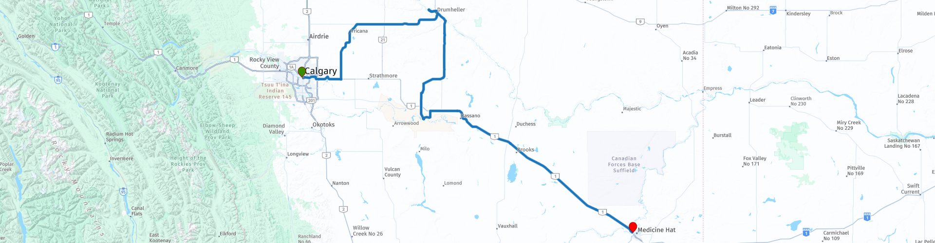
 This is part 7 running from Calgary to Medicine Hat.
The Trans Canada Highway passes through all the southern provinces of the country. The route can be driven in different ways. There are namely in various alternative routes that also belong to the TCH. The total distance is around 8,000 km. We not only drive the TCH, but will take the rural roads as much as possible, because only highway driving is too boring and Canada has many beautiful roads through its beautiful landscape.
You drive through all provinces and through very varied and scenic landscapes, from the Rockies in the West, the Central Prairies to the Eastern Maritimes and the Northern Forest.
The riding season is generally April through October with longer seasons on the west coast and southern Ontario.
Provide good all season clothing or bring rain gear, depending on the province and the season the weather can change and you may be surprised by a rain or even a snow or hail shower, so be prepared.
In Canada the metric system is used, so speeds are indicated in Km / h. A helmet requirement (DOT approved) applies throughout Canada.
You will see many wildlife throughout Canada. your similar animals from province to province, such as deer, buffalos, moose, caribou, wolves, pumas, bears, mountain goats, sheep, lynx, coyotes, foxes, raccoons, badgers, various rodents and all kinds of birds.
Even if it is very tempting to stop for a photo, don't do it, it can be very dangerous.
 Share this route


Animation

Verdict


Duration
5h 49m

Mode of travel
Car or motorcycle

Distance
440.65 km

Countries

 RouteXpert Review
 When leaving the city we drive past some beautiful sights such as;
The Calgary Tower (RP2), this downtown tower is 190m high and opened in 1968 under the name Husky Tower. The tower was built as part of a project to beautify the inner cities of several Canadian metropolises at the time of Canada's 100th anniversary.
Olympic Plaza on the left (RP3) is a wonderful destination for downtown Calgary workers for lunch. The square was built for the 1988 Winter Olympics and has the only chilled ice surface outside in the city. Calgary City Hall is on the right.
Just outside the city we drive along Chestermere Lake (RP5), a man-made reservoir constructed by the Canadian Pacific Railway in the 1880s, to irrigate the area between Calgary and Strathmore. It is now mainly used for recreational purposes, such as swimming, windsurfing, fishing and ice skating (in winter).
The region east of Calgary is part of the "Palliser Triangle", a dry region in southeastern Alberta, with little vegetation, flat and straight roads, so there are hardly any panoramas. To make the ride more interesting, I have included a number of sights in the review, which are marked with a route point and POI;
RP9 Midland Provincial Park was established in 1979 to preserve an important chapter in Alberta's coal mining history. Explore the local mining history in Midland Coal Mine Day Use Area with the old mining company office and the Midland Coal Interpretive Trail.
RP10. The Royal Tyrrell Museum of Palaeontology is the only museum in Canada devoted exclusively to the study of ancient life. In addition to one of the world's largest dinosaur displays, they offer a wide variety of creative, fun and educational programs that bring the prehistoric past to life.
RP11. The nearby Homestead Antique Museum of their ingenuity and perseverance by displaying their wares, furniture, artistic instruments and implements; all presented in ambiance settings.
At RP12 there is the possibility to have lunch.
RP13. Blackfoot Crossing Museum is the historic place of signature of Convention No. 7 in 1877 and is of national and international historical and archaeological significance. It is a designated national heritage site and is recommended as a World Heritage Site. The success of the Treaty No. 7 commemoration in 1877 reinforced the vision of the Siksika (Blackfoot) Nation to build a unique world-class tourist attraction designed to engage visitors in authentic cultural experiences with the Blackfoot people. The Siksika people are proud to present Blackfoot Crossing Historical Park to the world.
After this tour through history we turn onto the Trans-Canadian Highway at RP17 and drive the last 170 kilometers south-east towards Medicine Hat.
I rate this route with 3 *** Stars because of the beautiful sights at the beginning of the route. The ride itself is quite boring and there are no options for driving on a different route.


 Links
Links  Usage
Usage Want to download this route?
You can download the route for free without MyRoute-app account. To do so, open the route and click 'save as'. Want to edit this route?
No problem, start by opening the route. Follow the tutorial and create your personal MyRoute-app account. After registration, your trial starts automatically.  Disclaimer
Use of this GPS route is at your own expense and risk. The route has been carefully composed and checked by a MyRoute-app accredited RouteXpert for use on TomTom, Garmin and MyRoute-app Navigation.
Changes may nevertheless have occurred due to changed circumstances, road diversions or seasonal closures. We therefore recommend checking each route before use.
Preferably use the route track in your navigation system. More information about the use of MyRoute-app can be found on the website under 'Community' or 'Academy'.