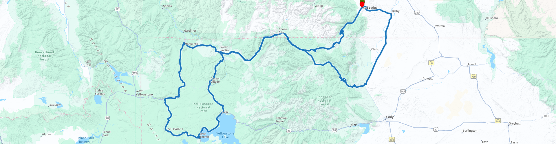
Red Lodge to Old Faithfull Two Day Round trip Beartooth Highway and Yellowstone Park

Esta ruta fue hecha por:
RouteXpert René Plücken (MRA Master)
Última edición: 20-08-2025
 Resumen de ruta
 En el camino se pueden visitar varios lugares hermosos del Parque Yellowstone, hay hermosos lagos, cascadas y sobre todo muchos géiseres y pozos de barro.
Tenga en cuenta que la autopista Beartooth no está abierta todo el año, así que planifique su viaje con antelación. Es recomendable recorrerla entre finales de mayo y mediados de octubre, cuando la carretera suele estar abierta y accesible. Sin embargo, debido a la gran altitud y al clima impredecible, la carretera puede estar cerrada temporalmente incluso durante estos meses.
Califico este viaje con 5 estrellas por los hermosos caminos sinuosos y el paisaje.
 Compartir esta ruta


Animation

Veredicto


Duración
33h 36m

Modo de viaje
Coche o motocicleta

Distancia
542.80 km

Países

 Revisión de RouteXpert
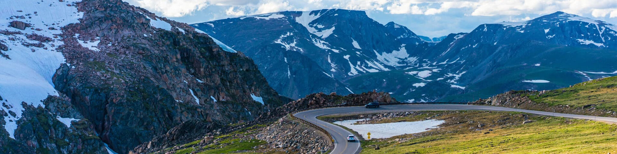
 La ruta presenta una serie de zigzags empinados y caminos sinuosos, siguiendo la frontera entre Montana y Wyoming hasta el Paso Beartooth, a 10 847 m (35 000 pies), y requiere un ciclista experimentado. El desnivel estimado es de entre 1600 m (5200 pies) y 2400 m (8000 pies) en 19 km (12 millas) de paisajes audaces.
Conduciendo de este a oeste, llegará a los tramos más altos de la Beartooth Highway hasta una amplia meseta en la parte superior del paso, luego descenderá hasta el cruce con Wyoming Highway 296 (Chief Joseph Scenic Byway) en Cooke City, la entrada noreste al Parque Nacional de Yellowstone.
A lo largo del camino, pasará por numerosos lagos típicos del Área Silvestre Absaroka-Beartooth, que recorre gran parte de la ruta. Tómese su tiempo para disfrutar del trayecto y deténgase a observar los alrededores o aparque para admirar el paisaje y tomar fotos. Hay varios campamentos y zonas de picnic cerca de los lagos que ofrecen excelentes oportunidades para tomar fotos.
En Silver Gate (antes parte de Cooke City) puedes planificar el almuerzo y cargar combustible, antes de ingresar al Parque Yellowstone por la hermosa carretera escénica, a lo largo de la ruta hay varias áreas de estacionamiento donde puedes detenerte para disfrutar del entorno y tomar fotografías, algunas de las cuales están incluidas en esta reseña.
- Mammoth Hot Springs cuenta con un sendero de 3,5 millas con senderos para caminatas que pasan por manantiales y una cascada.
- Terrace Springs con un corto sendero para caminar sobre pasarelas a lo largo de algunos hermosos manantiales.
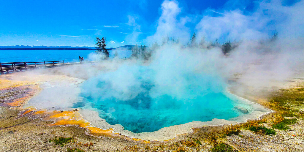
- Sendero Fountain Paint Pot, donde podrá observar diversas formaciones hidrotermales que son expresión del volcán Yellowstone, aún activo. Dentro de este sistema geológico, se encuentran representados todos los tipos de formaciones termales. Se pueden agrupar en dos categorías generales: aquellas con abundante agua (aguas termales y géiseres) y aquellas con agua limitada (pozas de lodo y fumarolas). A pesar de sus similitudes estructurales, no hay dos formaciones exactamente iguales.
El sendero de la Cuenca Bisquit es un hermoso sendero panorámico que atraviesa diversas formaciones geotérmicas en un paseo marítimo acondicionado. Cerrado debido a una erupción el 23 de julio de 2024.
Nos alojaremos en el Old Faithful Inn, uno de los alojamientos más populares del Parque Nacional de Yellowstone, así que reserve con antelación. Este hotel goza de una ubicación ideal con vistas al mundialmente famoso géiser Old Faithful y ofrece numerosas ventajas y beneficios que no encontrará en ningún otro lugar. El hotel cuenta con más de 300 habitaciones, incluyendo suites recientemente renovadas y habitaciones premium que combinan elementos clásicos y modernos, testimonio de la historia de Yellowstone.
Hay una serie de puntos de referencia incluidos en esta ruta donde puedes detenerte para tomar una fotografía del hermoso paisaje y las cascadas;
- La cascada Kepler Cascades, que fluye rápidamente a través de un desfiladero rocoso justo al sur de Old Faithful Village, atrae a grandes multitudes de visitantes a una región dominada por géiseres.
- Cuenca de géiseres West Thumb y lago Yellowstone, la cuenca de géiseres más grande en las orillas del lago Yellowstone (incluida la cuenca Potts al norte).
El Centro de Visitantes y Museo del Puente de Pesca, un excelente lugar para visitar. En este antiguo edificio de madera, descubrirá la gran variedad de fauna que habita en y alrededor del lago más grande de Norteamérica, de más de 2130 metros de altura. El centro de visitantes cuenta con diversas exhibiciones de animales, como osos pardos, águilas calvas, cisnes trompeteros y muchos más.
- Le Hardy's Rapids es una sección del río Yellowstone donde el lecho del río desciende ligeramente, arrojando el agua contra grandes rocas y creando aguas bravas turbulentas.
El borde de las Cataratas Inferiores y el Mirador Inferior son lugares increíbles para disfrutar de la vista de las imponentes Cataratas Inferiores del río Yellowstone. Tenga cuidado, el camino al estacionamiento no está pavimentado.
Cataratas Tower. Un sendero corto conduce al mirador. Las Cataratas Tower son una cascada en Tower Creek, en el noreste del Parque Nacional de Yellowstone, Wyoming, EE. UU. A unos 1000 metros río arriba de la confluencia del arroyo con el río Yellowstone, la cascada tiene una caída de 40 metros.
En Canyon Village puedes parar para almorzar y cargar combustible.
Una vez que haya completado el Gran Circuito de Yellowstone, regrese por la Carretera Beartooth hasta Red Lodge. Disfrute del regreso y disfrute de una perspectiva diferente del hermoso paisaje.

 Enlaces
  Uso
Uso ¿Quiere descargar esta ruta?
Puede descargar la ruta gratis sin la cuenta de MyRoute-app. Para hacerlo, abra la ruta y haga clic en 'guardar como'. ¿Quiere editar esta ruta?
No hay problema, comience abriendo la ruta. Siga el tutorial y cree su cuenta personal de MyRoute-app. Después de registrarse, su prueba comienza automáticamente.  Descargo de responsabilidad
El uso de esta ruta GPS es por su cuenta y riesgo. La ruta ha sido cuidadosamente compuesta y verificada por un RouteXpert acreditado por MyRoute-app para su uso en TomTom, Garmin y MyRoute-app Navigation.
No obstante, es posible que se hayan producido cambios debido a circunstancias cambiantes, desvíos de carreteras o cierres estacionales. Por lo tanto, recomendamos comprobar cada ruta antes de utilizarla.
Utilice preferentemente el track de ruta en su sistema de navegación. Más información sobre el el uso de la aplicación MyRoute se puede encontrar en el sitio web en 'Comunidad' o 'Academia'.