
Day 28 TCH Charlottetown to Truro

This route was brought to you by:
RouteXpert René Plücken (MRA Master)
Last edit: 19-11-2025
 Route Summary
 This is section 28 which runs from Charlottetown to Truro.
The Trans-Canada Highway passes through all of the country's southern provinces. The route can be driven in various ways, as there are several alternative routes that also belong to the Trans-Canada Highway. The total distance is around 8,000 km. We won't be driving solely the Trans-Canada Highway, but will be taking as much of the country's back roads as possible, as highway driving alone is too boring, and Canada boasts many beautiful roads through its stunning landscape.
You'll drive through all the provinces and through very diverse and picturesque landscapes, from the Rockies in the west, the Central Prairies to the eastern Maritimes and the northern forest.
The riding season is generally from April to October with longer seasons on the west coast and southern Ontario.
Make sure you have good all-season clothing or bring rain gear. Depending on the province and the season, the weather can change suddenly and you might be surprised by a rain shower, or even a snow or hail shower, so be prepared.
In Canada, the metric system is used, so speeds are indicated in km/h. Helmets are mandatory throughout Canada (DOT approved).
Throughout Canada, you'll see plenty of wildlife. Similar animals vary from province to province, including deer, buffalo, moose, caribou, wolves, cougars, bears, mountain goats, sheep, lynx, coyotes, foxes, raccoons, badgers, various rodents, and a variety of birds.
Even though it is very tempting to stop for a photo, don't do it, it can be very dangerous.
This route features beautiful roads through a lovely green landscape, and you can spend a good portion of the day exploring Prince Edward Island National Park and the Cape Jourimain Nature Centre. Therefore, I rate this route 5***** stars.
 Share this route


Animation

Verdict


Duration
10h 3m

Mode of travel
Car or motorcycle

Distance
272.19 km

Countries

 RouteXpert Review
 Today we leave Prince Edward Island and drive to Nova Scotia, Canada's "New Scotland." A peninsula surrounded by the Atlantic Ocean, with green hills and picturesque bays reminiscent of the real Scotland. This drive is a mix of coastal roads, historic sites, and a touch of adventure.
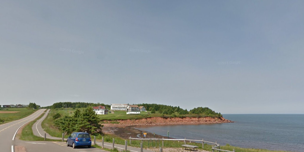
Before leaving the island, we'll take a detour to the north coast and Cavendish, a place where you can easily spend half a day. We'll visit
• Oceanview Lookoff to enjoy views over the Gulf of St. Lawrence and the red cliffs of Cavendish.
• Cavendish Visitors Centre for information about Prince Edward Island National Park.
• Green Gables, the iconic farmhouse from Anne of Green Gables, a literary must-see.
• Cavendish Beach, a wide, 8-kilometer sandy beach surrounded by red cliffs. Ideal for a stroll.
• Replica of the Space Shuttle Columbia. It's in very dilapidated condition, so don't expect a working attraction; it's mainly interesting for curious visitors.
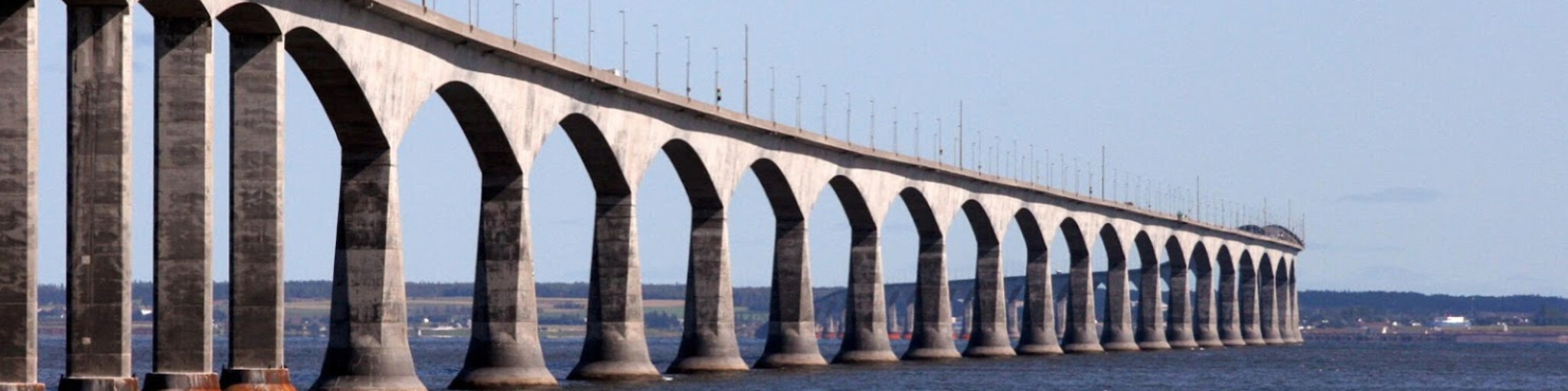
We have lunch in Carleton and, after paying the toll, drive over the Confederation Bridge back to New Brunswick.
Just before the bridge ends is the Cape Jourimain Nature Centre, an eco-center with walking trails, a historic lighthouse, and an observation tower offering panoramic views of the bridge. It's a great place to stop for some photos.
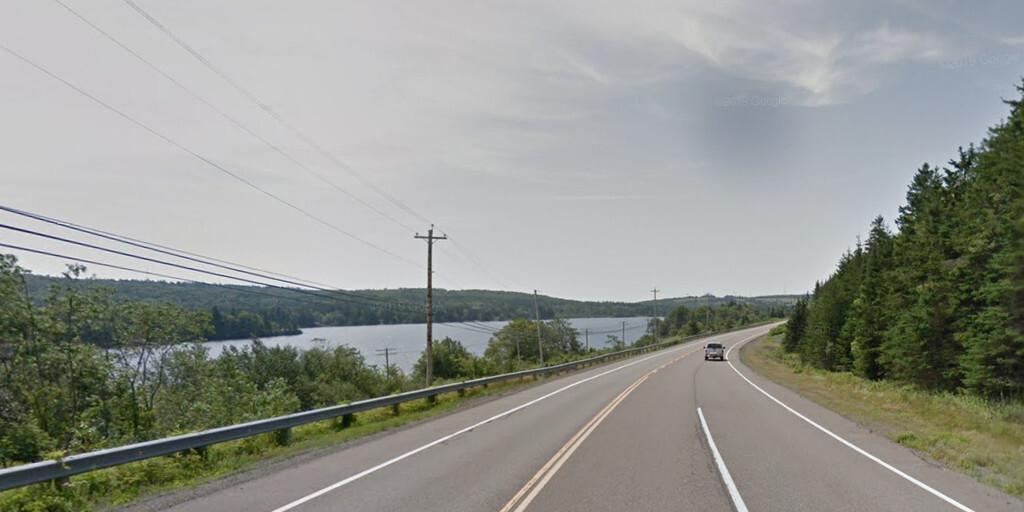
After a short stretch on the TCH, we take the Cherry Burton Road, which winds along the coast from Baie Verte to Nova Scotia.
The next 120 km are pure pleasure: winding roads through green hills, past small villages, streams, and lakes. Every now and then, you'll see the glint of the bay between the trees.
Our final stop is at Catch of the Bay for delicious fish and chips. The restaurant, shaped like a fishing boat and lighthouse, is a real attraction, and the food is delicious. On the other side, you can refuel for the next day. With a full belly, we drive the last 20 km to Truro, our final destination for the day.
My rating: ★★★★★. A route full of contrasts: red cliffs, historic sites, an iconic bridge, and green hills. Take time to explore Cavendish and Cape Jourimain; this day is a highlight of the trip.
 Links
Links  Usage
Usage Want to download this route?
You can download the route for free without MyRoute-app account. To do so, open the route and click 'save as'. Want to edit this route?
No problem, start by opening the route. Follow the tutorial and create your personal MyRoute-app account. After registration, your trial starts automatically.  Disclaimer
Use of this GPS route is at your own expense and risk. The route has been carefully composed and checked by a MyRoute-app accredited RouteXpert for use on TomTom, Garmin and MyRoute-app Navigation.
Changes may nevertheless have occurred due to changed circumstances, road diversions or seasonal closures. We therefore recommend checking each route before use.
Preferably use the route track in your navigation system. More information about the use of MyRoute-app can be found on the website under 'Community' or 'Academy'.

Prince Edward Island
About this region
Prince Edward Island (PEI) is one of the thirteen provinces and territories of Canada. It is the smallest province in terms of land area and population, but the most densely populated. The island has several nicknames: "Garden of the Gulf", "Birthplace of Confederation" and "Cradle of Confederation". Its capital and largest city is Charlottetown. It is one of the three Maritime provinces and one of the four Atlantic provinces.
Part of the traditional lands of the Miꞌkmaq, it was colonized by the French in 1604 as part of the colony of Acadia. The island was ceded to the British at the conclusion of the French and Indian War in 1763 and became part of the colony of Nova Scotia, and in 1769 the island became its own British colony. PEI hosted the Charlottetown Conference in 1864 to discuss a union of the Maritime provinces; however, the conference became the first in a series of meetings which led to Canadian Confederation in 1867. PEI initially balked at Confederation but, facing bankruptcy from the Land Question and construction of a railroad, joined as Canada's seventh province in 1873.
According to Statistics Canada, the province of PEI has 158,717 residents. The backbone of the island economy is farming; it produces 25% of Canada's potatoes. Other important industries include the fisheries, tourism, aerospace, bio-science, IT, and renewable energy. As PEI is one of Canada's older settlements, its population still reflects some of the earliest settlers, with Canadien, Scottish, Irish, and English surnames being dominant.
PEI is located in the Gulf of St. Lawrence, about 200 kilometres (120 miles) north of Halifax, Nova Scotia and 600 kilometres (370 miles) east of Quebec City, and has a land area of 5,686.03 km2 (2,195.39 sq mi). The main island is 5,620 km2 (2,170 sq mi) in size. It is the 104th-largest island in the world and Canada's 23rd-largest island.
Read more on Wikipedia
Part of the traditional lands of the Miꞌkmaq, it was colonized by the French in 1604 as part of the colony of Acadia. The island was ceded to the British at the conclusion of the French and Indian War in 1763 and became part of the colony of Nova Scotia, and in 1769 the island became its own British colony. PEI hosted the Charlottetown Conference in 1864 to discuss a union of the Maritime provinces; however, the conference became the first in a series of meetings which led to Canadian Confederation in 1867. PEI initially balked at Confederation but, facing bankruptcy from the Land Question and construction of a railroad, joined as Canada's seventh province in 1873.
According to Statistics Canada, the province of PEI has 158,717 residents. The backbone of the island economy is farming; it produces 25% of Canada's potatoes. Other important industries include the fisheries, tourism, aerospace, bio-science, IT, and renewable energy. As PEI is one of Canada's older settlements, its population still reflects some of the earliest settlers, with Canadien, Scottish, Irish, and English surnames being dominant.
PEI is located in the Gulf of St. Lawrence, about 200 kilometres (120 miles) north of Halifax, Nova Scotia and 600 kilometres (370 miles) east of Quebec City, and has a land area of 5,686.03 km2 (2,195.39 sq mi). The main island is 5,620 km2 (2,170 sq mi) in size. It is the 104th-largest island in the world and Canada's 23rd-largest island.
View region
 Statistics
  2
2Amount of RX reviews (Prince Edward Island)
 10161
10161Amount of visitors (Prince Edward Island)
 121
121Amount of downloads (Prince Edward Island)
 Route Collections in this region
 Trans Canada Highway
The Trans-Canada Highway (TCH) or Trans-Canadian Highway is a system of highways that cover all 10 provinces of Canada.
The Federal and Provincial Highways System that now forms the TCH were authorized by the Trans-Canada Highway Act of 1948 and opened in 1962. It was completed in 1971. The total length of the TCH is 7821 km.
Contrary to the American Interstate Highway System, the TCH does not consist of an unambiguous network of motorways, but forms a network of restricted access highways and other main routes that are more akin to the Dutch provincial roads. The route is indicated by a green shield with a white maple leaf.
The numbering of the roads that are part of the TCH is the domain of the provinces. Only the western provinces have aligned their numbering and the TCH has the designation Highway 1 there.
The main route of the TCH starts in Victoria in British Columbia and runs via Calgary and Regina to Winnipeg. From Winnipeg the route leads to Kenora in Ontario, after which several branches pass through Ontario to Ottawa.
Further east, the route passes through the province of Quebec via Montreal and Quebec, among others, to Moncton, New Brunswick. Then the TCH continues east through Nova Scotia, where a branch (via the Confederation Bridge) leads to Prince Edward Island. Another section runs down to the sea in the port city of Sydney, where a ferry service leaves for Channel-Port aux Basques on the island of Newfoundland. From there the route continues for more than 900 km to the provincial capital of St. John's, in the extreme southeast of the island.
We not only drive the TCH, but will take the rural roads as much as possible, because only Highway driving is too boring and Canada has many beautiful roads through its beautiful landscape. You drive through all provinces and through very varied and scenic landscapes, from the Rockies in the West, the Central Prairies to the Eastern Maritimes and the Northern Forest.
The riding season is generally April through October with longer seasons on the west coast and southern Ontario. Provide good all season clothing or bring rain gear, depending on the province and the season the weather can change and you may be surprised by a rain or even a snow or hail shower, so be prepared.
In Canada the metric system is used, so speeds are indicated in Km / h. A helmet requirement (DOT approved) applies throughout Canada.
You will see many wildlife throughout Canada. This varies from province to province, such as deer, buffalos, moose, caribou, wolves, pumas, bears, mountain goats, sheep, lynx, coyotes, foxes, raccoons, badgers, various rodents and all kinds of birds. Even if it is very tempting to stop for a photo, don't do it, it can be very dangerous.
The routes described in this review sometimes deviate from the Trans Canada Highway, bringing the total length to 9,300 kilometers. The routes are made so that you drive through the beautiful parts of Canada with truly beautiful panoramas and beautiful sights to visit, this differs from museums, parks to historical points. The routes are not too long so there is time to stop for photos and sights along the way. You can also choose to arrange and combine the stages differently or to add other routes to shorten or extend your journey. The routes are marked with a rating in stars, some routes are less challenging or interesting but are necessary to drive to the next point, which is why they often have a lower rating.
In the route description you will find more details about the routes and the points of interest along the way. These points and also hotels, restaurants, petrol stations etc. are indicated with a POI and sometimes also with a Route point. In the description you will also find links to interesting sites and to the routes that connect to that day.
The described routes are;
Day 01 TCH Victory to Nanaimo
Day 02 TCH Nanaimo to Hope
Day 03 TCH Hope to Kamloops
Day 04 TCH Kamloops to Revelstoke
Day 05 TCH Revelstoke to Lake Louise
Day 06 TCH Lake Louise to Calgary
Day 07 TCH Calgary to Medicine Hat
Day 08 TCH Medicine Hat to Moose Jaw
Day 09 TCH Moose Jaw to Regina
Day 10 TCH Regina to Brandon
Day 11 TCH Brandon to Winnipeg
Day 12 TCH Winnipeg to Kenora
Day 13 TCH Kenora to Ignace
Day 14 TCH Ignace to Thunder Bay
Day 15 TCH Thunder Bay to Marathon
Day 16 Thunder Bay to Wawa
Day 17 TCH Wawa to Sault Ste Marie
Day 18 TCH Sault Ste Marie to Espanola
Day 19 TCH Espanola to Mattawa
Day 20 TCH Mattawa to Ottawa
Day 21 TCH Ottawa to Montreal
Day 22 TCH Montreal to Quebec
Day 23 TCH Quebec to Riviere du Loup
Day 24 TCH Riviere du Loup to Grand Falls
Day 25 TCH Grand Falls to Fredericton
Day 26 TCH Fredericton to Moncton
Day 27 TCH Moncton to Charlottetown
Day 28 TCH Charlottetown to Truro
Day 29 TCH Truro to North Sydney
Day 30 TCH North Sydney to Corner Brook
Day 31 TCH Corner Brook to Grand Falls
Day 32 TCH Grand Falls to Clarenville
Day 33 TCH Clarenville to St John.
Have fun reading the reviews and planning your next road trip.
If you have driven this trip, I am very curious about your feedback!
View Route Collection