01 Tour von Jaun ueber Col du Pillon und Grosser St Bernhard nach Aosta

This route was brought to you by:
RouteXpert David Ruprecht
Last edit: 18-10-2023
 Route Summary
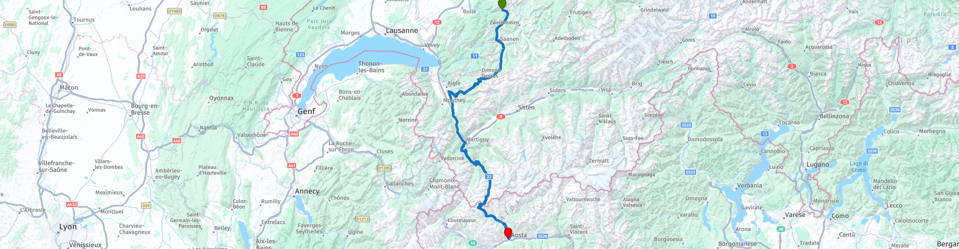
 In addition to wonderful serpentines and cruiser curves, the ride also offers beautiful viewing areas and several options for stops to view impressive landscapes and historical buildings.
This day tour deserves four stars because of the varied surroundings and exciting route.
It is a fairly easy route to ride with a few steeper and narrower sections that are easy to master even for beginners. But as always: adjust your speed and be vigilant.
 Share this route


Animation

Verdict


Duration
7h 10m

Mode of travel
Car or motorcycle

Distance
188.32 km

Countries


 RouteXpert Review
 This day tour deserves four stars because of the varied surroundings and exciting route.
It is a fairly easy route to ride with a few steeper and narrower sections that are easy to master even for beginners. But as always: adjust your speed and be vigilant.
We start from the dreamy village of Jaun in the Freiburg Alps and dive into the little-known side valley of Abläntschen. We follow the Jäunli, as the small forerunner of the Jaunbach is called with the typical Swiss diminutive, to the junction towards Saanen. We head closely to the right into the lovely mountain village of Abläntschen, which is always worth a detour with its idyllic wooden church. But we turn left and follow the sign to Saanen. Attention, like all Alpine passes, this small pass is closed in winter. Caution is advised on the route to Saanen, because there has been a public bus route since 2022 and you often come across a minibus on the narrow road. It's worth taking a short stop at the top of the pass to admire the Swiss Dolomites, as the Gastlosen chain is also called. A look back shows the Gastlosen on the left, the Bäderhorn in the middle and the Hundsrück on the right - a wonderful photo opportunity.
The journey down to Saanen should be taken slowly as the road has some damage and it is confusing. Through alpine meadows and then forest we follow the Griessbach before the road branches off to the left to the hamlet of Unterbort and flows into the main road.
We cross Saanen and bypass Gstaad. A short stop in the well-known mountain village offers great shopping opportunities and you can immerse yourself in high society, where you often meet celebrities from business, showbiz and film. But we drive past it and begin the climb to the Col du Pillon at the back of the Saane Valley, in Gsteig. The curved cruiser curves quickly lead us to the top of the pass. Here we have a coffee and can admire the impressive mountains. Here too, a trip with the gondola to the Scex rouge would be a tempting option, where you can enjoy a view of the Valais, Vaud and Bernese Alps at around 3,000 meters above sea level in just a few minutes. But you should reserve a few hours for this, which is why we skip it and drive down to Les Diablerets refreshed.
Towards the end of the village we drive via the train station and bypass to the ramp of the Col de la Croix. It's worth stopping to take photos at the top of the pass. We head down winding paths into Valais, where we travel on the fast main road to Martigny. If you want it faster, you can also take the motorway to the Grosser St. Bernhard exit (note: a vignette is required on Swiss motorways).
In Les Valettes we turn right away from the official pass access road and take the path through the small, dreamy side valley of the Durnand. And already in the first part of the forest, at the first sharp left bend, we park our motorcycles. It's time for lunch and a visit to the Durnand Gorge. The breathtaking gorge has been expanded with footbridges and paths and the entrance fee is definitely worth it.
After the refreshing coolness of the gorge, we head through the Durnand Valley high over the Col de Champex to the Lac de Champex, where we stop to capture the picturesque area photographically. After this short stop we head down to Orsières, where we follow the official main road to the Great St. Bernard again. In Bourg St. Pierre, history comes to life at the old, but newly renovated, mill. We reach the mill, built in 1681, via the bridge that Charlemagne had built around the year 800. Since the mill can only be visited inside for two hours on about four Sundays, we admire it from the outside and soon get back on our bikes.
After a few kilometers and the longer avalanche gallery, we turn away from the main road as it now flows into the toll tunnel. We want to go over the old pass road, which after a short time winds its way up through narrow curves. We quickly reach the top of the pass, where the temperatures can be quite cool even in summer. At the pass lake we treat ourselves to a coffee and something sweet while looking at the mighty mountains. If you want, you can buy a plush St. Bernard from one of the souvenir shops, in memory of the legend of Barry, the world-famous St. Bernard dog with his little barrel around his neck. However, we continue without any further and enjoy the wonderful windings of the pass road down to Saint-Leonard.
We quickly join the traffic again, which had missed all the beauty of the heights coming from the tunnel. There are some historical buildings and parts of the road to see down the valley, but we only see them from a distance and at a fast pace. We now want to go to Aosto, the destination of our first stage. And we want to visit and enjoy this wonderful, unique town. It's just as wonderful in the evening sun as it is the next morning. The Museum Pass, which is valid for the Historical Museum and various historical buildings, is highly recommended. This is an impressive way to learn about the history of the expansion of the Roman Empire in this region.
We chose the Hotel Norden Palace as our place to stay overnight. A cheap, clean and nice hotel very close to the old town. There are parking spaces in the immediate vicinity of the hotel and if the room is on one of the upper floors, you have a fantastic view over the old town and the entire valley.


 Links
Links  Usage
Usage Want to download this route?
You can download the route for free without MyRoute-app account. To do so, open the route and click 'save as'. Want to edit this route?
No problem, start by opening the route. Follow the tutorial and create your personal MyRoute-app account. After registration, your trial starts automatically.  Disclaimer
Use of this GPS route is at your own expense and risk. The route has been carefully composed and checked by a MyRoute-app accredited RouteXpert for use on TomTom, Garmin and MyRoute-app Navigation.
Changes may nevertheless have occurred due to changed circumstances, road diversions or seasonal closures. We therefore recommend checking each route before use.
Preferably use the route track in your navigation system. More information about the use of MyRoute-app can be found on the website under 'Community' or 'Academy'.

Bern
About this region
Bern (German: [bɛrn] (listen); Alemannic German: Bärn [b̥æːrn]) or Berne (French: [bɛʁn] (listen); Arpitan: Bèrna [ˈbɛʁna] (listen); Italian: Berna [ˈbɛrna]; Romansh: Berna [ˈbɛrnɐ] (listen)) is the de facto capital of Switzerland, referred to by the Swiss as their "federal city" (in German: Bundesstadt, French: ville fédérale, and Italian: città federale). With a population of about 144,000 (as of 2020), Bern is the fifth-most populous city in Switzerland. The Bern agglomeration, which includes 36 municipalities, had a population of 406,900 in 2014. The metropolitan area had a population of 660,000 in 2000.Bern is also the capital of the canton of Bern, the second-most populous of Switzerland's cantons. The official language is German, but the main spoken language is the local variant of the Alemannic Swiss German dialect, Bernese German. In 1983, the historic old town (in German: Altstadt) in the centre of Bern became a UNESCO World Heritage Site.
Read more on Wikipedia
View region
 Statistics
  29
29Amount of RX reviews (Bern)
 20379
20379Amount of visitors (Bern)
 1978
1978Amount of downloads (Bern)
 Route Collections in this region
 The 24 Most Beautiful Alpine Routes
The Alps, The Alps are a mountain range in Europe, stretching from the French Mediterranean coast in the southwest to the Pannonian Plain in the east. The area of the mountain range is more than 200,000 km².
In other words Passes and Mountain Roads!
Driving through the mountains is great! Especially over the mountain passes with hairpin bends and narrow winding roads. Every bend a different view where you can enjoy. There are many beautiful mountain passes in the Alps.
A selection that has also been incorporated into these routes:
The Stlevio Pass:
The Stelvio Pass, also known as Passo dello Stelvio, is mainly known for the stage in the Giro d'Italia. Due to the length and the difference in height, this pass is seen as one of the toughest tests in cycling. The Stelvio Pass reaches a maximum height of 2758 meters and is therefore one of the highest in the Alps. The pass connects the towns of Bormio and Prato Allo Stelvio. In winter the pass is closed due to heavy snowfall.
The Reschenpass:
The Reschenpass, also known as Passo di Resia, connects the Austrian state of Tyrol with the Italian province of South Tyrol. The pass reaches a maximum height of 1,504 meters and has been one of the most important north-south connections in the Alps in recent centuries. The pass was used long before Roman times. Along the way you will pass several highlights and historical relics. One of the highlights is the Reschensee. This lake was created after the construction of the dam and has completely submerged the village of Graun. The only thing that reminds of that is the clock tower in the middle of the lake.
Col du Galibier:
The French mountain pass Col du Galibier connects the towns of Saint-Michel-de-Maurienne and Briançon via the Col du Lautaret in the south and the Col du Télégraphe in the north. The mountain pass is part of the Tour de France and very much feared, due to the fact that it can only be reached via the other two mountain passes. The pass reaches a maximum height of 2646 meters. From there you can take a walk to the viewpoint at 2704 meters. You can admire the peaks of the Grand Galibier, Mont Blanc and La Meije here.
The Grossglockner High Alpine Road:
With a height of 3798 meters the Grossglockner is the highest mountain in Austria. To fully enjoy this impressive mountain, you can drive over the Grossglockner High Alpine Road and the accompanying pass. The route starts from Bruck am Grossglockner and ends in Heiligenblut. Of course you can drive in two directions. The pass reaches a maximum height of 2504 meters and is closed in winter due to heavy snowfall. Along the way you pass several stops with fun activities, information points, mountain huts and viewpoints. A visit to the Kaiser-Franz-Josefs-Höhe and Pasterzen Glacier is highly recommended.
The Col d'Izoard:
Just like the Col du Galibier, the Col d'Izoard is also part of a stage of the Tour de France. The mountain pass connects Briançon with the valley of the river Guil. The pass is partly located in the Regional Natural Park du Queyras and reaches a maximum height of 2360 meters. What is special about the Col d'Izoard is the barren and rocky landscape. Sometimes it feels like driving a car over the moon! Along the way you can stop at several points to enjoy the beautiful view.
The Bernina Pass:
The Bernina Express is one of the most famous rail trains in Switzerland and the Alps. The route is beautiful and partly included on the UNESCO World Heritage List. Parallel to the railway lies the Bernina pass, which connects the Veltlin valley with the Egandin valley. This beautiful Alpine road has a total length of 56 kilometers and reaches a maximum height of 2328 meters. Along the way you can enjoy views of the Morteratsch Glacier.
The Sella Pass:
The Sella Pass, also known as Passo di Sella, takes you over one of the most impressive mountain ranges in the Dolomites: the Sella massif. The pass connects Valle di Fassa with Val Gardena and reaches a maximum height of 2236 meters. At this height is also the border of the Italian provinces of Trentino and Bolzano. Along the way you can enjoy the view of this spectacular mountain world. Admire, for example, the three peaks of the Sasso Lungo massif, the Sella massif or the peaks of the Marmolada. You can also drive the Sella pass in combination with the Gardena pass, Pordoi pass and Campolongo pass.
The Grimsel Pass:
The Grimsel Pass connects Goms in Wallis with the Halis Valley in the Bernese Oberland. The pass reaches a maximum elevation of 2165 meters and is closed in winter due to snowfall. Over the centuries, the mountain pass has played an important role in trade between Switzerland and Italy. Now it is mainly the reservoirs that have an important function. These are used to generate electricity. The landscape you drive through is rugged, rocky and impressive. On top of the pass is a hotel and a restaurant with a special marmot park. The Dodensee (Totensee) is also located here. This lake owes its name to the many soldiers who died in the time of Napoleon.
The Gotthard Pass:
The Gotthard Pass, also known as Passo del San Gottardo and Saint Gotthard, connects the Swiss towns of Airolo and Andermatt. The mountain pass and associated tunnel are especially known among holidaymakers driving from Switzerland to Italy. But where the majority opt for the tunnel, it is precisely the pass that really completes the holiday. The Gotthard Pass has a length of about 26 kilometers and reaches a maximum height of 2106 meters. The route is beautiful and takes you along old villages and beautiful views.
The Silvretta High Alpine Road and Silvretta Pass:
The Paznaun Valley in Tyrol and the Montafon in Vorarlberg are connected by the Silvretta High Alpine Road. The route has a length of 22.3 kilometers and leads from Galtür to Partenen in 34 hairpin bends, via the 2032 meter high Bielerhöhe. The Silvrettasee is also located at this point, where you can enjoy a lovely walk. The pass is closed in winter due to snowfall.
The Simplon Pass:
Just like the Gotthard Pass, many holidaymakers also travel over the Simplon Pass every year. This mountain pass connects the Rhone Valley in the canton of Valais with the Valle d'Ossola in Piemonte. The pass is open all year round and reaches a maximum height of 2005 meters. Along the way you pass a number of buildings, including the well-known Simplon Hospiz from 1825. The hospiz is managed by the monks of St. Bernard. From the highest point on the pass, all kinds of hiking routes are possible and you will also come across a hotel where you can spend the night.
The Gerlos Pass:
The Gerlos Pass connects the Salzach Valley in the Salzburgerland with the Zillertal Valley in Tyrol. The pass is part of the Gerlos Alpenstraße and runs right through the Hohe Tauern National Park. Along the way you can enjoy beautiful views of the surroundings. The pass has a length of 12 kilometers and reaches a maximum height of 1531 meters. A ride over the Gerlos Pass can be ideally combined with a visit to the Krimmler Wasserfälle.
The Great St. Bernard Pass:
The Great St. Bernard Pass, better known as Col du Grand Saint Bernard, connects the Italian province of Valle d'Aosta with the Swiss canton of Valais. The pass is one of the highest in Switzerland and reaches a maximum height of 2469 meters. Like a number of other mountain passes in this list, the Great St. Bernard Pass has also been used as a connecting road for centuries. The pass is named after the St. Bernard dogs that used to help stranded travelers along with the monks. The pass is closed in winter.
The Timmelsjoch High Alpine Road:
The Timmelsjoch High Alpine Road connects the towns of Sölden in the Ötztal and Meran in South Tyrol. Tolls must be paid on the Hochgurgl - Moos route. Via a mountain road with about 60 hairpin bends you drive through a beautiful mountain world. With the Timmelsjoch Experience you can learn more about the history, the road and the environment via various stations. You can also visit the Top Mountain Crosspoint museum.
Col de l'Iseran:
With a maximum pass height of 2770 meters, the Col l'Iséran is one of the highest mountain passes in the Alps. The pass connects Bourg-Saint-Maurice with Bonneval-sur-Arc. Via a road full of hairpin bends you pass, among other things, Val-d'Isère and a side valley of the Maurienne that lies entirely in the National Park de la Vanoise. You can spot animals such as marmots and chamois and there is also a restaurant with a chapel on top of the pass.
The Gavia Pass:
The Gavia Pass (Italian Passo di Gavia) is a mountain pass in the Italian Alps, in the Lombardy region.
It is one of the highest pass roads in Europe. The road leads through the unspoilt Stelvio National Park. The road was built in the First World War to supply Italian soldiers who fought in the Italian-Austrian border area. The pass height is one of the most beautiful in the Alps. Here is the large Lago Bianco with, to the north, the mountain San Matteo (3684 meters). Lago Nero is slightly lower on the south side of the pass. Here the mountain group of the Adamello determines the view. There are many well-marked walks in the area. During the winter the pass is closed due to the heavy snowfall. The pass is often closed until May and June due to the large amount of snow.
Promoter has made a selection of the 24 Most Beautiful Alpine routes that they have set out in recent years.
The routes go through:
France
Austria
Switzerland
Italy
The most beautiful roads, the most beautiful views, the most beautiful viewpoints. The highest mountains, the fastest descents, hairpin bend after hairpin bend, you name it you can't get enough of it.
If you go on holiday in this region, take advantage of it, ALL routes in this collection have been checked and made equal for TomTom, Garmin and MyRoute-app Navigation by a MyRoute-app RouteXpert.
Have fun with this collection and while driving one of these routes. Enjoy all the beauty that the Alps and the Dolomites have to offer. Click on “View route” to read the review of the chosen route.
I would like to hear your findings about the route(s).
View Route Collection
11 day trip from the Netherlands
8 countries in 11 days; The Netherlands, Germany, Austria, Italy, Switzerland, France, Luxembourg and Belgium. This route collections consists of 10 routes that I have driven with friends in the summer of 2019.
The start is in Geldermalsen Netherlands, the first 7 days you drive through the Netherlands, Germany, Austria, Italy, Switzerland, France and a piece of Luxembourg with overnight stays in hotels.
The last three days you stay in Barweiler (D) in the Eifel and you drive two beautiful tours through the Eifel, Luxembourg and parts of the Belgian Ardennes.
There is no highway in the routes, only beautiful provincial and country roads, many beautiful passes with beautiful panoramas.
Be sure to check whether the passes are open before you leave.
These are routes for experienced drivers.
View Route Collection