R02 Elend to Harrachov

This route was brought to you by:
RouteXpert Hans van de Ven (Mr.MRA)
Last edit: 10-08-2021
 Route Summary
 @Marc Telkamp, thank you for making the routes available.
Good trip!
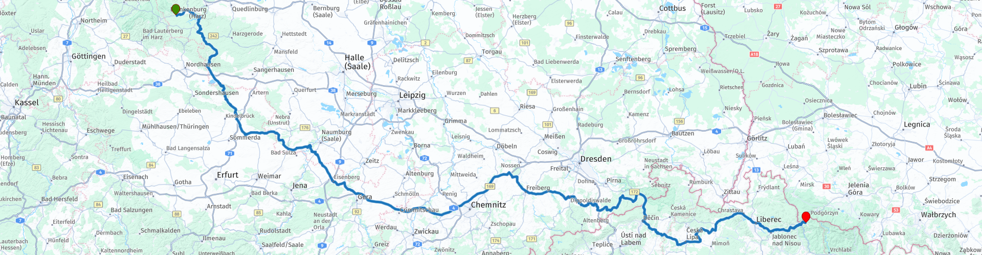
Starting point: Elend, Hotel Grüne Tanne.
End point: Harrachov, Hotýlek pod smrkem
The route is equalized for Garmin, TomTom and MRA Navigation.
 Share this route


Animation

Verdict


Duration
9h 50m

Mode of travel
Car or motorcycle

Distance
548.81 km

Countries


 RouteXpert Review
 After about 16 KM from the starting point, the 1st photo point of this route is already, or perhaps even actually, walking across the suspension bridge, TitanR, to the other side of the reservoir. After this stop it continues to the next spectacular part of this route, namely "The Kyffhäuser", this is the smallest mountain range in Germany. The ridge is approximately 19 km long and 7 km wide. The highest point is the Kulpenberg in Thuringia with 473.4 meters. The 1st 2KM of the route over this ridge is spectacular and full of beautiful curves, pay attention, because it is also called a race track.
The Kyffhäuser plays an important role in German traditional mythology. Here is said to be the resting place of Emperor Frederick Barbarossa, who drowned on June 10, 1190 in the Salef near the city of Silifke during the Third Crusade.
In 1890-1896, a monument to the late Emperor William I was erected on the ruins of Kyffhäuser Castle. By placing William's equestrian statue above Barbarossa, the Hohenzollern emphasized that they were in line with the medieval emperor and had restored his empire through German unification.
The prince in Kyffhäuser legend was originally not supposed to have been Frederik Barbarossa, but his illustrious grandson, Emperor Frederick II (1194-1250).
After this spectacular stretch, meander through the beautiful countryside from village to village to Stublach, where a stop is planned for lunch and just before lunch in Bad Köstritz, you can refuel along the route. After lunch you go on the highway for about 80 KM.
After the highway, the winding through the beautiful landscape starts again, where you regularly pass a village and it seems as if time has stood still here. After 400 KM you reach the border with the Czech Republic, where you have a petrol station just after the border.
Even now you meander through the beautiful landscape, now and then along a river, then through a village, but also through the city of Liberec, this city near the border triangle with Germany and Poland, is the capital of the region of the same name (Kraj). Since the Middle Ages Liberec has been the center of the textile industry in North Bohemia.
Pretty soon after you have left Liberec behind you, you can already see the giant mountains looming, because the end of this route and your bivouac for the coming days is in Harrachov, this is one of the most famous ski areas in the Czech Republic and is located in the west of the Giant Mountains. Harrachov is the third largest ski resort in the Czech Republic.
Despite a number of highway kilometers, I rate this route with 4 stars.


 Links
Links  Usage
Usage Want to download this route?
You can download the route for free without MyRoute-app account. To do so, open the route and click 'save as'. Want to edit this route?
No problem, start by opening the route. Follow the tutorial and create your personal MyRoute-app account. After registration, your trial starts automatically.  Disclaimer
Use of this GPS route is at your own expense and risk. The route has been carefully composed and checked by a MyRoute-app accredited RouteXpert for use on TomTom, Garmin and MyRoute-app Navigation.
Changes may nevertheless have occurred due to changed circumstances, road diversions or seasonal closures. We therefore recommend checking each route before use.
Preferably use the route track in your navigation system. More information about the use of MyRoute-app can be found on the website under 'Community' or 'Academy'.