01 Kalenborn Neunkirchen Labaroche

This route was brought to you by:
RouteXpert Travellexxie
Last edit: 14-08-2023
 Route Summary
 Because of the variety of beautiful roads and the different areas you cross, this route gets 5 stars.
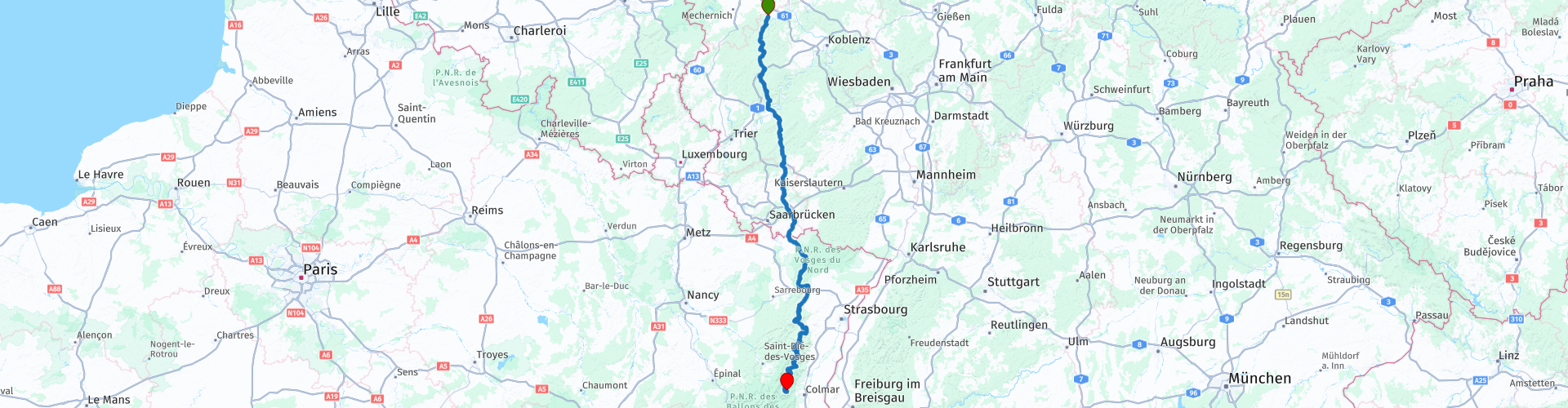
Start: Hotel Kalenborner Höhe
End: Hotel au Tilleul
 Share this route


Animation

Verdict


Duration
9h 44m

Mode of travel
Car or motorcycle

Distance
415.02 km

Countries


 RouteXpert Review
 In this first stage we start in Kalenborn in the hotel of the same name and cross the Eifel to begin with. This hotel was chosen because it is a great opportunity to drive. If you want to make the first stage less kilometers, there are plenty of hotels on the road through the Eifel. From the hotel it's all the way south on the B257, known to many as "the road to the Ring". That's correct. You drive through the village of Adenau, which is closely connected to the ring road. You drive through villages with the illustrious names Breidscheid, Quiddelbach and Müllenbach. Unfortunately you don't have much time and you better visit the Nürburgring another time. If you don't know this road, prepare yourself for nice long spins, but beware it can be busy.
After a short break in Ulmen, you soon come close to the Moselle. Shortly before you reach the Moselle, via a number of hairpin bends, you can take a beautiful photo of the bridge over the Moselle, built in 2019. A true architectural masterpiece. You continue your way, cross the Moselle and at Bernkastel Kues you dive into the tunnel, after which the Hunsrück is open to you. You take a short break and in Germany you can still fill up with "preisgünstig" and do so. If you cross the French border (which you don't notice at all, but suddenly everything smells French) DO NOT rely on POIs related to gas stations. Many gas stations are indicated around the place Bitche (just the name), but most of them no longer exist. Writer of this knows from experience, on petrol vapor and loud grumbling we once reached a gas station.
In France you can enjoy excellent food and you can do that in the restaurant Café du Havre.
After lunch you drive further south and from here you can only enjoy the beautiful Vosges. You will be treated to the most beautiful views, but what is even better, you will hardly be bothered by straight roads. Evidently, the longest straight stretch of road is less than 500 meters. Here you pass the highest point of the Vosges at the Tour du Champ du Feu. A large pillar on a roundabout not to be missed.
From bar Freppel, for a short break, it may get even more twisty, but be careful in this area as well. The French tend to cover their roads with a thick layer of gravel as a wearing course. That doesn't drive very well with 4 wheels, let alone with 2 wheels.
Eventually you will arrive at hotel au Tilleuil. The hotel consists of 2 parts. You can report to the left building and it is mainly for eating, the right building is mainly for sleeping. Garages are available behind the left building if you don't want to leave the motorcycle outside. The hotel is fine, the rooms are large and clean and the price is not too bad. Eating tip: you are in the Vosges and then tarte flambée with a portion of snails beforehand is a must.
When enjoying an Irish Coffee you think: Phew, long drive, but it was all worth it. I am happy with another wonderful MRA route.


 Links
Links  Usage
Usage Want to download this route?
You can download the route for free without MyRoute-app account. To do so, open the route and click 'save as'. Want to edit this route?
No problem, start by opening the route. Follow the tutorial and create your personal MyRoute-app account. After registration, your trial starts automatically.  Disclaimer
Use of this GPS route is at your own expense and risk. The route has been carefully composed and checked by a MyRoute-app accredited RouteXpert for use on TomTom, Garmin and MyRoute-app Navigation.
Changes may nevertheless have occurred due to changed circumstances, road diversions or seasonal closures. We therefore recommend checking each route before use.
Preferably use the route track in your navigation system. More information about the use of MyRoute-app can be found on the website under 'Community' or 'Academy'.

Grand Est
About this region
Grand Est (French: [ɡʁɑ̃t‿ɛst] (listen); Alsatian: Grossa Oschta; Moselle Franconian/Luxembourgish: Grouss Osten;
Rhine Franconian: Groß Oschte; German: Großer Osten [ˈɡʁoːsɐ ˈʔɔstn̩]; English: "Greater East") is an administrative region in Northeastern France. It superseded three former administrative regions, Alsace, Champagne-Ardenne and Lorraine, on 1 January 2016 under the provisional name of Alsace-Champagne-Ardenne-Lorraine (pronounced [alzas ʃɑ̃paɲ aʁdɛn lɔʁɛn]; ACAL or, less commonly, ALCA), as a result of territorial reform which had been passed by the French Parliament in 2014.The region sits astride three water basins (Seine, Meuse and Rhine), spanning an area of 57,433 km2 (22,175 sq mi), the fifth largest in France; it includes two mountain ranges (Vosges and Ardennes). It shares borders with Belgium, Luxembourg, Germany and Switzerland. As of 2017, it had a population of 5,549,586 inhabitants. The prefecture and largest city, by far, is Strasbourg.
The East of France has a rich and diverse culture, being situated at a crossroads between the Latin and Germanic worlds. This history is reflected in the variety of languages spoken there (Alsatian, Champenois, and Lorraine Franconian). Most of today's Grand Est region was considered "Eastern" as early as the 8th century, when it constituted the southern part of the Francian territory of Austrasia. The city of Reims (in Champagne), where Frankish king Clovis I had been baptized in 496 AD, would later play a prominent ceremonial role in French monarchical history as the traditional site of the coronation of the kings of France. The Champagne fairs played a significant role in the economy of medieval Europe as well. Alsace and Lorraine thrived in the sphere of influence of the Holy Roman Empire for most of the Middle Ages and Renaissance, and subject to competing claims by France and German over the centuries.
The region has distinctive traditions such as the celebration of Saint Nicholas Day, Christmas markets, or traditions involving the Easter hare in Alsace and Lorraine. Alsace-Moselle are furthermore subject to local law for historical reasons. With a long industrial history and strong agriculture and tourism (arts, gastronomy, sightseeing), the East of France is one of the top economic producing regions in the country.
Read more on Wikipedia
Rhine Franconian: Groß Oschte; German: Großer Osten [ˈɡʁoːsɐ ˈʔɔstn̩]; English: "Greater East") is an administrative region in Northeastern France. It superseded three former administrative regions, Alsace, Champagne-Ardenne and Lorraine, on 1 January 2016 under the provisional name of Alsace-Champagne-Ardenne-Lorraine (pronounced [alzas ʃɑ̃paɲ aʁdɛn lɔʁɛn]; ACAL or, less commonly, ALCA), as a result of territorial reform which had been passed by the French Parliament in 2014.The region sits astride three water basins (Seine, Meuse and Rhine), spanning an area of 57,433 km2 (22,175 sq mi), the fifth largest in France; it includes two mountain ranges (Vosges and Ardennes). It shares borders with Belgium, Luxembourg, Germany and Switzerland. As of 2017, it had a population of 5,549,586 inhabitants. The prefecture and largest city, by far, is Strasbourg.
The East of France has a rich and diverse culture, being situated at a crossroads between the Latin and Germanic worlds. This history is reflected in the variety of languages spoken there (Alsatian, Champenois, and Lorraine Franconian). Most of today's Grand Est region was considered "Eastern" as early as the 8th century, when it constituted the southern part of the Francian territory of Austrasia. The city of Reims (in Champagne), where Frankish king Clovis I had been baptized in 496 AD, would later play a prominent ceremonial role in French monarchical history as the traditional site of the coronation of the kings of France. The Champagne fairs played a significant role in the economy of medieval Europe as well. Alsace and Lorraine thrived in the sphere of influence of the Holy Roman Empire for most of the Middle Ages and Renaissance, and subject to competing claims by France and German over the centuries.
The region has distinctive traditions such as the celebration of Saint Nicholas Day, Christmas markets, or traditions involving the Easter hare in Alsace and Lorraine. Alsace-Moselle are furthermore subject to local law for historical reasons. With a long industrial history and strong agriculture and tourism (arts, gastronomy, sightseeing), the East of France is one of the top economic producing regions in the country.
View region
 Statistics
  83
83Amount of RX reviews (Grand Est)
 41191
41191Amount of visitors (Grand Est)
 13812
13812Amount of downloads (Grand Est)
 Route Collections in this region
 25 Magnificent trails in France
This MRA route collection contains 25 beautiful motorcycle routes in different parts of France, such as the Ardennes, the Alsace, Vercors, the Drôme, the Ardèche, Cote d'Azure, Gorges du Verdon, the Ariège, the Dordogne and Brittany.
The routes have been carefully created by Bert Loorbach, who is an enthusiastic motorcyclist himself. He lived in France for a year and a half, during which time he devoted himself to mapping the unknown and beautiful back roads of France especially for motorcyclists.
The routes are bundled in the Motortourgids France part 1 of Kosmos publishing house and now also available in MyRouteApp.
I have taken over the routes in MRA and sometimes adjusted them slightly to make them even more interesting for the motorcyclist.
View Route Collection
11 day trip from the Netherlands
8 countries in 11 days; The Netherlands, Germany, Austria, Italy, Switzerland, France, Luxembourg and Belgium. This route collections consists of 10 routes that I have driven with friends in the summer of 2019.
The start is in Geldermalsen Netherlands, the first 7 days you drive through the Netherlands, Germany, Austria, Italy, Switzerland, France and a piece of Luxembourg with overnight stays in hotels.
The last three days you stay in Barweiler (D) in the Eifel and you drive two beautiful tours through the Eifel, Luxembourg and parts of the Belgian Ardennes.
There is no highway in the routes, only beautiful provincial and country roads, many beautiful passes with beautiful panoramas.
Be sure to check whether the passes are open before you leave.
These are routes for experienced drivers.
View Route Collection