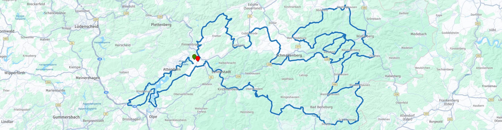
Roundtrip Sauerland Silbecke Winterberg Oberkirchen Silbecke

Cet itinéraire a été créé par:
RouteXpert René Plücken (MRA Master)
Dernière modification: 20-08-2025
 Résumé de l'itinéraire
 Le Sauerland est connu comme le pays des mille montagnes, vous aurez donc de nombreux défis à relever. Vous traversez des paysages vallonnés avec de longs virages parfois serrés. Vous gravissez un sommet de montagne via des virages en épingle à cheveux difficiles, le suivant est plus simple et plus facile, il y a donc beaucoup de variété.
Il existe de nombreuses possibilités d'hébergement dans le Sauerland, particulièrement destinées aux motocyclistes, avec de nombreux services et une très bonne gastronomie. Il y a des hôtels, des maisons de vacances et des maisons d'hôtes. Les propriétaires eux-mêmes sont souvent des passionnés de moto, ils savent donc ce dont vous avez besoin.
Le Sauerland présente un paysage très varié, composé principalement de chaînes de montagnes basses avec des sommets atteignant 840 mètres et de vallées profondes entre les deux. Cela signifie qu'il existe de nombreux itinéraires magnifiques à parcourir. L'asphalte est généralement de très bonne qualité.
Il y a de vastes forêts, des prairies herbeuses, des ruisseaux cristallins, des rivières et des réservoirs accueillants. Il y a cinq grands réservoirs dans le Sauerland ; le Sorpesee, le Hennesee, le Biggesee, le Diemelsee et le Möhnesee. En plus de cette belle nature, il y a aussi beaucoup à découvrir dans le domaine culturel dans les villages pittoresques, les villes animées, les châteaux majestueux et les ruines mystérieuses.
Cet itinéraire emprunte de belles routes avec les virages nécessaires, les longs virages et les virages en épingle à cheveux serrés. Vous passerez devant un certain nombre de lacs et de barrages de montagne. Ce sont de beaux endroits pour s'arrêter pour une photo.
Veuillez noter que certaines routes sont fermées aux motocyclistes pendant le week-end, au moment où cet itinéraire a été créé, il n'y avait aucune fermeture, mais si vous souhaitez parcourir cet itinéraire un samedi ou un dimanche, il est conseillé de vérifier si tout est ouvert.
J'estime que cet itinéraire vaut 5 étoiles.
 Partager cet itinéraire


Animation

Verdict


Durée
9h 18m

Mode de déplacement
Voiture ou moto

Distance
326.32 km

Pays

 RouteXpert Review
 C'est une zone de vacances populaire et la région est très fréquentée le week-end et pendant la haute saison, veuillez en tenir compte également, car certaines routes du Sauerland sont fermées aux motocyclistes le week-end. Il n'y a pas de routes fermées sur cet itinéraire, mais il est conseillé de vérifier les nouvelles fermetures si vous souhaitez parcourir cet itinéraire le week-end.
L'itinéraire part de notre maison de vacances à Silbecke, en fonction de votre point de départ, vous pouvez ajuster l'itinéraire. Nous nous rendons à Attendorn pour visiter la plate-forme panoramique « Biggeblick », d'où vous pourrez profiter d'une vue imprenable sur le Biggesee, le barrage et les environs à une hauteur de 90 mètres. C'est à quelques pas du parking.
Sur le chemin du retour vers Attendorn, vous pourrez faire le plein de votre vélo pour cette journée, la distance totale est d'environ 320 km et un deuxième arrêt carburant est prévu après environ 180 km.
Nous longeons les rives du Biggetalsperre et du Listertalsperre, le long de la route il y a un certain nombre de points où vous pouvez vous arrêter pour prendre des photos de ces réservoirs, comme au barrage « Listertalsperre ». Aujourd'hui, le Listertalsperre est une branche du Biggetalsperre, construit en 1965. Il a une capacité de réservoir de 21,6 millions de mètres cubes avec une profondeur d'eau maximale de 33,90 mètres. La centrale électrique de Lister produit environ 4,6 millions de kWh d'électricité par an grâce à une turbine Kaplan. Le Listertalsperre mesure 4 500 mètres de long et jusqu'à 400 mètres de large, ce qui représente une surface d'eau de 169 hectares. La population de poissons est très diversifiée et avec ses nombreuses zones de baignade, le Listertalsperre est une destination populaire pour les excursions et invite chaque année de nombreux visiteurs à la voile, à la pêche, au surf, à la natation, à la randonnée et au vélo.
Nous empruntons de belles routes sinueuses à travers le Sauerland verdoyant jusqu'à la ville de Winterberg, qui est une destination de vacances populaire en été mais surtout en hiver, en raison des nombreuses pistes de ski de cette région. À Winterberg, vous pouvez prévoir une pause déjeuner.
De Winterberg, nous roulons via Siedlinghausen, Bad Fredeburg et Oberkirchen jusqu'à Schmallenberg, vous pouvez raccourcir l'itinéraire en suivant les lignes 511 et 236 de Bad Fredeburg à Schmallenberg. Après avoir fait le plein à Bad Fredeburg, nous tournons à gauche et roulons vers Oberkirchen, un joli village avec des maisons blanches à colombages, il est donc agréable de s'arrêter et de faire une petite promenade dans le village.
Pour les amateurs de modélisme ferroviaire, il existe la possibilité de visiter le « Modellbahn am Rothaarsteig » à Grafschaft, un modèle réduit de chemin de fer de 66 m² dans une ancienne usine de tricotage. 92 trains circulent sur 550 mètres de voie. Quinze véhicules contrôlés par ordinateur circulent sur les voies ferrées miniatures et un système de contrôle de l'éclairage jour/nuit garantit qu'il fait nuit toutes les 24 minutes. En même temps, les lumières des maisons et des voitures s'allument grâce au contrôle du temps et du hasard. Le prix d'entrée est de 6 €.
À Schmallenberg, vous pouvez prévoir une dernière pause et déguster une boisson ou une glace sur la place chaleureuse de la ville. Depuis Schmallenberg, il faut encore environ une heure de route sur de belles routes sinueuses jusqu'à Silbecke, la dernière section le long de la rivière Lenne où vous passez devant la centrale hydroélectrique de Bamenohl, construite entre 1921 et 1923.
Dans cette revue, vous trouverez des liens avec des informations supplémentaires sur la moto dans le Sauerland.


 Liens
Liens  Utilisation
 Vous voulez télécharger cette route?
Vous pouvez télécharger l'itinéraire gratuitement sans compte MyRoute-app. Pour ce faire, ouvrez l'itinéraire et cliquez sur 'enregistrer sous'. Vous voulez éditer cette route?
Pas de problème, commencez par ouvrir la route. Suivez le tutoriel et créez votre compte personnel MyRoute-app. Après l'enregistrement, votre essai démarre automatiquement.  Avertissement
L'utilisation de cet itinéraire GPS est à vos propres frais et risques. L'itinéraire a été soigneusement composé et vérifié par un RouteXpert accrédité par MyRoute-app pour une utilisation sur TomTom, Garmin et MyRoute-app Navigation.
Des modifications peuvent néanmoins s'être produites en raison de circonstances modifiées, de déviations de routes ou de fermetures saisonnières. Nous vous recommandons donc de vérifier chaque itinéraire avant de l'utiliser.
Utilisez de préférence le tracé de l'itinéraire dans votre système de navigation. Plus d'informations sur le l'utilisation de MyRoute-app peut être trouvée sur le site Web sous 'Communauté' ou 'Académie'

La Rhénanie-du-Nord-Westphalie
À propos de cette région
La Rhénanie-du-Nord-Westphalie (/vɛst.fa.li/ ; en allemand : Nordrhein-Westfalen ; en bas allemand : Noordrhien-Westfalen, souvent abrégé NRW) est un État fédéré de l'ouest de l'Allemagne. C'est le Land allemand le plus peuplé et doté du plus fort poids économique, en partie grâce à la Ruhr. La Rhénanie-du-Nord–Westphalie abrite plus de 23 % de la population allemande (18 millions) et contribue à environ 22 % du produit intérieur brut de l'Allemagne. Mais son poids économique dépassant largement les frontières de l'Allemagne, elle se place ainsi en tête des régions de l'Union européenne en étant première en matière de produit intérieur brut (PIB) à PPA. Sa superficie est de 34 083 km2. Sa capitale est Düsseldorf et la plus grande ville est Cologne.
En savoir plus sur Wikipedia
Afficher la région
 Statistiques
  140
140Nombre de critiques RX (La Rhénanie-du-Nord-Westphalie)
 79268
79268Nombre de visiteurs (La Rhénanie-du-Nord-Westphalie)
 34156
34156Nombre de téléchargements (La Rhénanie-du-Nord-Westphalie)
 Acheminer les collections dans cette région
 Les 10 plus beaux itinéraires en voiture et moto du Limbourg
Le Limbourg, qui pense au Limbourg, pense au flan, aux mines de charbon, à la marne et aux collines. Les mines de charbon sont fermées depuis près de 40 ans, le dernier chargement de charbon a été apporté de la mine de charbon Oranje-Nassau à Heerlen le 31 décembre et, comme on dit, le sud du Limbourg est passé du noir au vert et, malheureusement, il reste encore peu à gauche vue de cette période.
Mais pas seulement de la tarte, de la marne et du charbon au Limbourg, mais aussi une très belle province à visiter en voiture ou à moto et profiter de toute la beauté que la province du Limbourg a à offrir. Pour cela, l'application MyRoute RouteXpert a concocté pour vous un Top 10 des itinéraires Voiture et Moto.
Tous les itinéraires de cette collection ont été vérifiés et rendus égaux pour TomTom, Garmin et MyRoute-app Navigation par une MyRoute-app RouteXpert.
Si vous pensez que j'ai un très bel itinéraire qui ne devrait certainement pas manquer à cette collection, envoyez-le à :
email: routeexpert@myrouteapp.com
Sujet : Nouvelle route pour la collection Top 10 Province du Limbourg composée par Hans van de Ven.
Le parcours sera ensuite revu puis ajouté au Top 10.
Pour que le Top 10 soit également le Top 10, 1 itinéraire devra disparaître du Top 10, vous pouvez l'indiquer lors de la soumission du nouvel itinéraire.
Amusez-vous avec cette collection et en conduisant l'un de ces itinéraires. Profitez de toute la beauté que les Pays-Bas et en particulier la province du Limbourg ont à offrir. Cliquez sur « Voir l'itinéraire » pour lire l'avis de l'itinéraire choisi.
J'aimerais connaître vos conclusions sur le(s) itinéraire(s).
Afficher la collection d'itinéraires
Top 5 des itinéraires en voiture et en moto dans l'Eifel
L'Eifel est la partie orientale du moyen plateau Eifel-Ardennes. Elle est située au nord de la Moselle et à l'ouest du Rhin. La plus grande partie est en Allemagne, une petite partie est en Belgique, dans les Cantons de l'Est. La partie allemande de l'Eifel est située dans les États fédéraux de Rhénanie du Nord-Westphalie et de Rhénanie-Palatinat. Le point culminant est le Hohe Acht avec 747 mètres.
Plusieurs chaînes peuvent être distinguées dans l'Eifel :
La partie la plus septentrionale s'appelle le Nordeifel, qui en Belgique se raccorde aux Hautes Fagnes ;
A l'est se trouve l'Ahrgebirge, cette partie est située au nord de l'Ahr dans le quartier Ahrweiler ;
Au sud de l'Ahr se trouve le Hohe Eifel (ou Hocheifel), dont le Hohe Acht (747 m) est le point culminant, et aussi le point culminant de toute la région de l'Eifel ;
À l'ouest, près de la frontière belge, les collines sont connues sous le nom de Schneifel, faisant partie de la zone plus large de l'Eifel des neiges avec des sommets atteignant 698 mètres ;
Au sud et à l'est du Hohe Eifel se trouve le Volcan-Eifel, une zone volcanique avec de nombreux lacs de cratère (Maare).
La partie sud de l'Eifel est moins haute. La région est traversée par des ruisseaux et des rivières qui coulent vers le sud. Ces ruisseaux se jettent dans la Moselle. Le plus grand de ces fleuves est le Kyll ; les collines autour de cette rivière sont connues sous le nom de Kyllwald ;
Au sud, l'Eifel se termine dans le Voreifel.
Au nord de l'Eifel, il y a quelques grands réservoirs. Le plus grand d'entre eux est le réservoir de la Roer qui a été créé par la construction du barrage de Roerdal.
Le Nürburgring est également situé dans l'Eifel, un circuit automobile bien connu pour les courses de Formule 1, entre autres. Depuis 2004, une partie du nord de l'Eifel est devenue le parc national de l'Eifel. Ce parc national fait entièrement partie du parc naturel germano-belge Hautes Fagnes-Eifel. Une autre partie de l'Eifel fait partie du parc naturel du sud de l'Eifel.
Connu dans tous les Pays-Bas et la Belgique en voiture et en moto, c'est donc une raison suffisante pour que l'application MyRoute RouteXpert compile pour vous un Top 5 des itinéraires en voiture et en moto.
Tous les itinéraires de cette collection ont été vérifiés et rendus égaux pour TomTom, Garmin et MyRoute-app Navigation par une MyRoute-app RouteXpert.
Si vous pensez que j'ai un très bel itinéraire qui ne devrait certainement pas manquer à cette collection, envoyez-le à :
email : routeexpert@myrouteapp.com
Sujet : Nouvelle route pour la collection Top 5 Eifel composée par Hans van de Ven.
Le parcours sera alors revu puis ajouté au Top 5. Pour que le Top 5 soit également le Top 5, 1 parcours devra disparaître du Top 5, vous pouvez l'indiquer lors de la soumission du nouveau parcours.
Amusez-vous avec cette collection et en conduisant l'un de ces itinéraires. Profitez de toute la beauté que l'Eifel a à offrir. Cliquez sur « Voir l'itinéraire » pour lire l'avis de l'itinéraire choisi.
J'aimerais connaître vos conclusions sur le(s) itinéraire(s).
Afficher la collection d'itinéraires