05 Van Bad Bruckenau naar Keulen via Natuurpark LahnDill Bergland en het Westerwald

This route was brought to you by:
RouteXpert Leonor Orban - Sr. RouteXpert
Last edit: 26-11-2023
 Route Summary
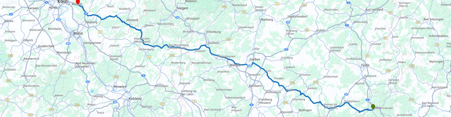
 The last ride takes you from the Rhön towards Köln. In order to quickly cover a distance of 500 km in 1 day, this route alternates between fast main roads and highways. This rhythm was chosen to avoid the boredom of a long highway ride home. Each time you drive inland for an hour and then eat up kilometers on a highway. The shortcuts are also fast. You're making good progress; You can also enjoy wonderfully long rolling bends.
There are plenty of sights along the way. Given the nature of the ride (back home), only a giant sequoia is included as a point of interest to stop and view.
The route gets 4 stars. It's not the most beautiful ride you'll ever ride. It's a nice ride to head home - still enjoying it. There are a few wonderful breaks along the way. And the changing landscape means that you will never be bored for a moment.
 Share this route


Animation

Verdict


Duration
5h 10m

Mode of travel
Car or motorcycle

Distance
253.68 km

Countries

 RouteXpert Review
 This last day of travel is a great way to cover a large number of kilometers in a pleasant way. Inland stretches alternate with highway sections, never longer than an hour. Because of this variety, the route makes good progress without ever getting boring. The inside parts are a pleasure. At no point will you have a technically challenging road, but the gentle curves and beautiful views make it a comfortable journey.
After a final breakfast at Hotel zur Mühle, the journey to the West begins. You leave the small spa town and drive over the rolling hills towards the towns of Schlüchtern, Steinau an der Straße and Nidda. The main road winds its way through the valleys, past open fields and the occasional forest. Just before Steinau you have a short stretch of highway, but the rest of the way to Nidda is on main roads.
Once in Nidda it is already 90 minutes on the road. If you want, you can take a break in the town at one of the marked spots. On a hot day, an ice cream at the local gelateria can be pleasantly cooling. Or maybe take a short break at the city café?
From Nidda the main road takes a route through the woods. Fortunately, an impressive giant sequoia was spared. Don't rush past the entrance to the tree. It is a narrow dead end road, where you see an old Baroque forester's house. The giant sequoia in question is close to this building. The enormous sequoia is said to have been planted around 1860 and has currently reached a height of 31 meters and a width of 6 meters.
At Gießen there is a slightly longer stretch of highway to bridge. Fortunately, after about 30 kilometers you can leave the highway again to dive into the Westerwald. Here you reach the highest point of your route. You probably won't notice much of this, as this is only an altitude of 600 meters.
What you probably notice is a slight rumbling in your stomach. It's time to find a lunch spot. There are 2 bakeries along the route, where you can choose from various sandwiches with a good cup of coffee, tea or soft drink. First you can moor at Bäckerei Grund. If there is no room there, then go a little further along the route at Backhaus Hehl Brot-Zeit.
You also follow the main roads in the Westerwald. This way you can maintain a nice pace without having to take to the highway. One moment you are driving through a town or sleeping village, the next moment through a valley or forest area. There is plenty to see along the way. In addition to this varied landscape, you will also see a number of castles and fortresses.
The first is Burgruine Herrenbröl. This knight's seat was probably built in the 13th century. In the centuries since, it has changed hands several times, without ever being of political or strategic importance. During the last occupation of the Rhineland by the French, it was destroyed in 1807. Remains such as a wall, cellar and tower have been preserved. If all goes well, you will see it from the road. It is otherwise not worth visiting.
The second is Burg Herrnstein. This house, like Herrenbröl, was built in the 13th century and renovated in the 19th and 20th centuries. The building has Baroque elements and the upper floors are built in half-timbered style. The castle is currently not open for visits.
The third is Burg Sülz. It is said to have been built in the 8th century. It was for a time in the possession of the Siegburg Abbey; the majority, on the other hand, are privately owned. Large-scale renovations took place in the 18th century and 20th century. Today it is a “technology court”, where about 20 technical companies have their workshops.
Finally you arrive at Landgasthof Heideblick, close to the city of Cologne. Here you can take a pleasant break before the last part of your journey home begins.
Hopefully you have had five wonderful days of riding, riding varied routes through different regions in Germany, which will give you inspiration to explore new areas again and again.


 Links
Links  Usage
Usage Want to download this route?
You can download the route for free without MyRoute-app account. To do so, open the route and click 'save as'. Want to edit this route?
No problem, start by opening the route. Follow the tutorial and create your personal MyRoute-app account. After registration, your trial starts automatically.  Disclaimer
Use of this GPS route is at your own expense and risk. The route has been carefully composed and checked by a MyRoute-app accredited RouteXpert for use on TomTom, Garmin and MyRoute-app Navigation.
Changes may nevertheless have occurred due to changed circumstances, road diversions or seasonal closures. We therefore recommend checking each route before use.
Preferably use the route track in your navigation system. More information about the use of MyRoute-app can be found on the website under 'Community' or 'Academy'.

North Rhine-Westphalia
About this region
North Rhine-Westphalia (German: Nordrhein-Westfalen, pronounced [ˌnɔʁtʁaɪn vɛstˈfaːlən] (listen); Low Franconian: Noordrien-Wesfale; Low German: Noordrhien-Westfalen; Colognian: Noodrhing-Wäßßfaale), commonly shortened to NRW (German: [ɛnʔɛʁˈveː] (listen)), is a German state (Land) in Western Germany. With more than 17.9 million inhabitants, it is the most populous state of Germany. Covering an area of 34,084 square kilometres (13,160 sq mi), it is the fourth-largest German state by size. Apart from the city-states, it is also the most densely populated state in Germany.
North Rhine-Westphalia features 30 of the 81 German municipalities with over 100,000 inhabitants, including Cologne (over 1 million), the state capital Düsseldorf, Dortmund and Essen (all about 600,000 inhabitants) and other cities predominantly located in the Rhine-Ruhr metropolitan area, the largest urban area in Germany and the third-largest on the European continent. The location of the Rhine-Ruhr at the heart of the European Blue Banana makes it well connected to other major European cities and metropolitan areas like the Randstad, the Flemish Diamond and the Frankfurt Rhine-Main Region.
North Rhine-Westphalia was established in 1946 after World War II from the Prussian provinces of Westphalia and the northern part of Rhine Province (North Rhine), and the Free State of Lippe by the British military administration in Allied-occupied Germany and became a state of the Federal Republic of Germany in 1949. The city of Bonn served as the federal capital until the reunification of Germany in 1990 and as the seat of government until 1999.
Culturally, North Rhine-Westphalia is not a uniform area; there are significant differences, especially in traditional customs, between the Rhineland region on the one hand and the regions of Westphalia and Lippe on the other. The state has always been Germany's powerhouse with the largest economy among the German states by GDP figures.
Read more on Wikipedia
North Rhine-Westphalia features 30 of the 81 German municipalities with over 100,000 inhabitants, including Cologne (over 1 million), the state capital Düsseldorf, Dortmund and Essen (all about 600,000 inhabitants) and other cities predominantly located in the Rhine-Ruhr metropolitan area, the largest urban area in Germany and the third-largest on the European continent. The location of the Rhine-Ruhr at the heart of the European Blue Banana makes it well connected to other major European cities and metropolitan areas like the Randstad, the Flemish Diamond and the Frankfurt Rhine-Main Region.
North Rhine-Westphalia was established in 1946 after World War II from the Prussian provinces of Westphalia and the northern part of Rhine Province (North Rhine), and the Free State of Lippe by the British military administration in Allied-occupied Germany and became a state of the Federal Republic of Germany in 1949. The city of Bonn served as the federal capital until the reunification of Germany in 1990 and as the seat of government until 1999.
Culturally, North Rhine-Westphalia is not a uniform area; there are significant differences, especially in traditional customs, between the Rhineland region on the one hand and the regions of Westphalia and Lippe on the other. The state has always been Germany's powerhouse with the largest economy among the German states by GDP figures.
View region
 Statistics
  137
137Amount of RX reviews (North Rhine-Westphalia)
 71409
71409Amount of visitors (North Rhine-Westphalia)
 31003
31003Amount of downloads (North Rhine-Westphalia)
 Route Collections in this region
 The 10 most beautiful car and motorcycle routes in Limburg
Limburg, who thinks of Limburg, thinks of flan, coal mines, marl and the hill country. The coal mines have been closed for almost 40 years, the last load of coal was brought up from the Oranje-Nassau coal mine in Heerlen on 31 December and, as they say, South Limburg was transformed from Black to Green and unfortunately there is still little left. view of this period.
But not only pie, marl and coal in Limburg, but also a very beautiful province to tour by car or motorcycle and enjoy all the beauty that the province of Limburg has to offer. For this, the MyRoute app RouteXpert has put together a Top 10 of Car and Motorcycle routes for you.
All routes in this collection have been checked and made equal for TomTom, Garmin and MyRoute-app Navigation by a MyRoute-app RouteXpert.
If you think, I have a very nice route that should certainly not be missing from this collection, send it to:
email: routeexpert@myrouteapp.com
Subject: New Route for the Top 10 collection Province of Limburg composed by Hans van de Ven.
The route will then be reviewed and then added to the Top 10.
To make the Top 10 also the Top 10, 1 route will have to disappear from the Top 10, you can indicate this when submitting the new route.
Have fun with this collection and while driving one of these routes. Enjoy all the beauty that the Netherlands and in particular the province of Limburg has to offer. Click on “View route” to read the review of the chosen route.
I would like to hear your findings about the route(s).
View Route Collection
Top 5 Car and Motorcycle Routes in the Eifel
The Eifel is the eastern part of the medium plateau Eifel-Ardennes. It is located north of the Moselle and west of the Rhine. The largest part is in Germany, a small part is in Belgium, in the East Cantons. The German part of Eifel is located in the federal states of North Rhine-Westphalia and Rhineland-Palatinate. The highest point is the Hohe Acht with 747 meters.
Several chains can be distinguished in the Eifel:
The northernmost part is called the Nordeifel, which in Belgium connects to the High Fens;
To the east of this is the Ahrgebirge, this part is located north of the Ahr in the Ahrweiler district;
South of the Ahr is the Hohe Eifel (or Hocheifel), of which the Hohe Acht (747 m) is the highest point, and also the highest point in the entire Eifel region;
To the west, near the Belgian border, the hills are known as Schneifel, part of the wider Snow Eifel area with peaks reaching up to 698 metres;
South and east of the Hohe Eifel is the Volcano-Eifel, a volcanic area with many crater lakes (Maare).
The southern part of the Eifel is less high. The area is bisected by streams and rivers running southwards. These streams flow into the Moselle. The largest of these rivers is the Kyll; the hills around this river are known as the Kyllwald;
In the south, the Eifel ends in the Voreifel.
In the north of the Eifel there are some large reservoirs. The largest of these is the reservoir in the Roer that was created by the construction of the Roerdal dam.
The Nürburgring is also located in the Eifel, a well-known car circuit for Formula 1 races, among other things. Since 2004, part of the north of the Eifel has become the Eifel National Park. This National Park falls entirely within the German-Belgian nature park High Fens-Eifel. Another part of the Eifel falls within the South Eifel Nature Park.
Well-known throughout the Netherlands and Belgium by car and motorcyclists, so reason enough for the MyRoute app RouteXpert to compile a Top 5 of Car and Motorbike routes for you.
All routes in this collection have been checked and made equal for TomTom, Garmin and MyRoute-app Navigation by a MyRoute-app RouteXpert.
If you think, I have a very nice route that should certainly not be missing from this collection, send it to:
email: routeexpert@myrouteapp.com
Subject: New Route for the Top 5 collection Eifel composed by Hans van de Ven.
The route will then be reviewed and then added to the Top 5. To make the Top 5 also the Top 5, 1 route will have to disappear from the Top 5, you can indicate this when submitting the new route.
Have fun with this collection and while driving one of these routes. Enjoy all the beauty that the Eifel has to offer. Click on “View route” to read the review of the chosen route.
I would like to hear your findings about the route(s).
View Route Collection