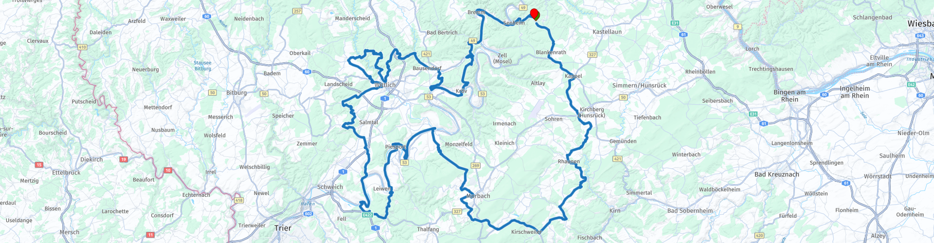
Rondrit Liesenich Morbach Piesport Wittlich Gripperath

This route was brought to you by:
RouteXpert Marinus van Deudekom
Last edit: 10-08-2025
 Route Summary
 Whether you come for the twists and turns, the views, or just want to enjoy a nice tour and a good schnitzel and a cold drink along the way: this route ticks all your motorcycle holiday boxes.
Because of the diversity of this route I rate it 5 stars.
Start and end point: Haus Buchholz Liesenich
 Share this route


Animation

Verdict


Duration
8h 52m

Mode of travel
Car or motorcycle

Distance
293.00 km

Countries

 RouteXpert Review
 You depart from Liesenich, a village where the morning mist still hangs between the rooftops. Here, the journey begins gently, with narrow lanes through the fields. But the first bends are not long in coming. Via Blankenrath and Kappel, you are slowly drawn into the Hunsrück, the heart of the countryside.
Lindenschied passes by like a whisper, and just outside the village stands the silent witness to a past we barely understand: the Wasserbehälter Liedenschied. A concrete giant, hidden in the forest. Cold, gray, yet possessing a certain beauty.
As you continue, the villages seem glued to the hills, but Herrstein, in particular, beckons you to stop. Cobblestones under your boots, half-timbered facades overhead – it feels like you're walking through a picture book.
Then the landscape becomes more rugged. The hills grow higher, the horizon broader. This is the Hunsrück in all its rugged glory. Wind in your visor, the scent of pine in the air. Sometimes you encounter no one. Just the road, you, and the deep green.
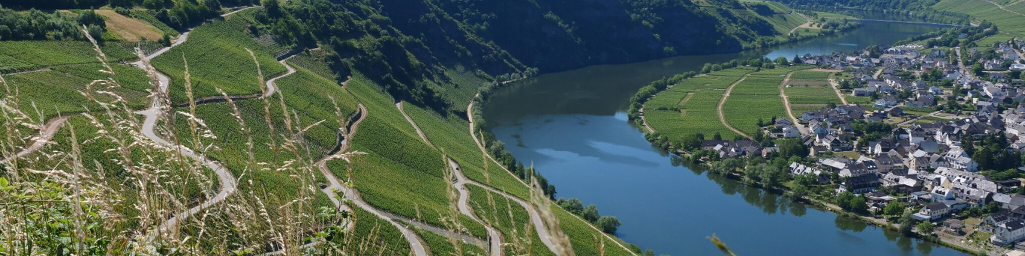
From Morbach, the atmosphere changes. You plunge down to the Moselle. Vines appear endlessly, as if they've always grown here.
At the Minheimer Kapellchen – a small chapel overlooking the valley – you can pause for a moment. Here, a silence reigns that is almost tangible. A place to breathe.
Piesport awaits below, picturesquely situated by the water. A place where the sun always seems to shine. You can feel it: here, people live more slowly, more consciously. A glass of wine beckons, but for now, just sitting and watching the river flow is enough.
Then comes the part that makes motorcyclists' hearts beat faster. After Trittenheim, Mehring, and Bruch (where you can briefly admire the rugged silhouette of Burg Bruch), the roads improve again.
Curves. Hairpins. Climbing, descending, turning, leaning. You're dancing with your machine. You hear nothing but the whooshing wind and the rhythm of your engine.
You drive through forests, over ridges, past fields full of flowers.
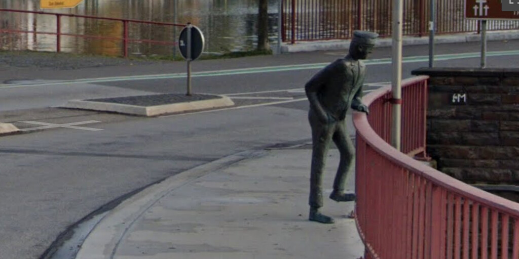
And then: Bullay. There he stands, without explanation, without warning. The "Spitting Man," a man made of stone, spitting water. Comical and strange at the same time. You have to smile. And maybe you think: yes, this is part of it. This crazy world full of beauty and absurdity.
You continue along the Moselle, passing through a few small villages and finally negotiating some beautiful hairpin bends before ending in Liesenich, where you started. The circle is complete.
What remains when the engine dies? Perhaps the smell of a wet forest. The descent along the Moselle in the golden evening light. Or that moment you paused, at the top of a hill, and heard nothing but birdsong and the ticking of your warm engine.
This route isn't a race. It's a ride you'll feel long after you've returned home. For those who love silence, curves, and stories in stone.
The route includes several places where you can grab a bite to eat and drink for yourself and your motorcycle. Are you required to stop here? No, of course you can choose your own stops.
You'll finish the route at the Haus Buchholz parking lot, where you can enjoy a snack and a drink while reflecting on today's journey. Are you required to stop here, yourself and your bike? No, of course you can choose your own stops.
 Links
Links  Usage
Usage Want to download this route?
You can download the route for free without MyRoute-app account. To do so, open the route and click 'save as'. Want to edit this route?
No problem, start by opening the route. Follow the tutorial and create your personal MyRoute-app account. After registration, your trial starts automatically.  Disclaimer
Use of this GPS route is at your own expense and risk. The route has been carefully composed and checked by a MyRoute-app accredited RouteXpert for use on TomTom, Garmin and MyRoute-app Navigation.
Changes may nevertheless have occurred due to changed circumstances, road diversions or seasonal closures. We therefore recommend checking each route before use.
Preferably use the route track in your navigation system. More information about the use of MyRoute-app can be found on the website under 'Community' or 'Academy'.

Rheinland Pfalz
About this region
Rhineland-Palatinate (German: Rheinland-Pfalz, [ˈʁaɪ̯nlant ˈp͡falt͡s] (listen)) is a western state of Germany. It covers 19,846 km2 (7,663 sq mi) and has about 4.05 million residents. It is the ninth largest and sixth most populous of the sixteen states. Mainz is the capital and largest city. Other cities are Ludwigshafen am Rhein, Koblenz, Trier, Kaiserslautern and Worms. It is bordered by North Rhine-Westphalia, Saarland, Baden-Württemberg and Hesse and by the countries France, Luxembourg and Belgium.
Rhineland-Palatinate was established in 1946 after World War II, from parts of the former states of Prussia (part of its Rhineland province), Hesse and Bavaria (its former outlying Palatinate kreis or district), by the French military administration in Allied-occupied Germany. Rhineland-Palatinate became part of the Federal Republic of Germany in 1949 and shared the country's only border with the Saar Protectorate until the latter was returned to German control in 1957. Rhineland-Palatinate's natural and cultural heritage includes the extensive Palatinate winegrowing region, picturesque landscapes, and many castles and palaces.
Read more on Wikipedia
Rhineland-Palatinate was established in 1946 after World War II, from parts of the former states of Prussia (part of its Rhineland province), Hesse and Bavaria (its former outlying Palatinate kreis or district), by the French military administration in Allied-occupied Germany. Rhineland-Palatinate became part of the Federal Republic of Germany in 1949 and shared the country's only border with the Saar Protectorate until the latter was returned to German control in 1957. Rhineland-Palatinate's natural and cultural heritage includes the extensive Palatinate winegrowing region, picturesque landscapes, and many castles and palaces.
View region
 Statistics
  141
141Amount of RX reviews (Rheinland Pfalz)
 51759
51759Amount of visitors (Rheinland Pfalz)
 28863
28863Amount of downloads (Rheinland Pfalz)
 Route Collections in this region
 Top 5 Car and Motorcycle Routes in the Eifel
The Eifel is the eastern part of the medium plateau Eifel-Ardennes. It is located north of the Moselle and west of the Rhine. The largest part is in Germany, a small part is in Belgium, in the East Cantons. The German part of Eifel is located in the federal states of North Rhine-Westphalia and Rhineland-Palatinate. The highest point is the Hohe Acht with 747 meters.
Several chains can be distinguished in the Eifel:
The northernmost part is called the Nordeifel, which in Belgium connects to the High Fens;
To the east of this is the Ahrgebirge, this part is located north of the Ahr in the Ahrweiler district;
South of the Ahr is the Hohe Eifel (or Hocheifel), of which the Hohe Acht (747 m) is the highest point, and also the highest point in the entire Eifel region;
To the west, near the Belgian border, the hills are known as Schneifel, part of the wider Snow Eifel area with peaks reaching up to 698 metres;
South and east of the Hohe Eifel is the Volcano-Eifel, a volcanic area with many crater lakes (Maare).
The southern part of the Eifel is less high. The area is bisected by streams and rivers running southwards. These streams flow into the Moselle. The largest of these rivers is the Kyll; the hills around this river are known as the Kyllwald;
In the south, the Eifel ends in the Voreifel.
In the north of the Eifel there are some large reservoirs. The largest of these is the reservoir in the Roer that was created by the construction of the Roerdal dam.
The Nürburgring is also located in the Eifel, a well-known car circuit for Formula 1 races, among other things. Since 2004, part of the north of the Eifel has become the Eifel National Park. This National Park falls entirely within the German-Belgian nature park High Fens-Eifel. Another part of the Eifel falls within the South Eifel Nature Park.
Well-known throughout the Netherlands and Belgium by car and motorcyclists, so reason enough for the MyRoute app RouteXpert to compile a Top 5 of Car and Motorbike routes for you.
All routes in this collection have been checked and made equal for TomTom, Garmin and MyRoute-app Navigation by a MyRoute-app RouteXpert.
If you think, I have a very nice route that should certainly not be missing from this collection, send it to:
email: routeexpert@myrouteapp.com
Subject: New Route for the Top 5 collection Eifel composed by Hans van de Ven.
The route will then be reviewed and then added to the Top 5. To make the Top 5 also the Top 5, 1 route will have to disappear from the Top 5, you can indicate this when submitting the new route.
Have fun with this collection and while driving one of these routes. Enjoy all the beauty that the Eifel has to offer. Click on “View route” to read the review of the chosen route.
I would like to hear your findings about the route(s).
View Route Collection
Route collection hairpins in the Eifel
This collection is composed of the most beautiful and winding roads in the Eifel. Forget Bundesstraßen, forget the road along the Moselle, if you have driven these roads, you can really say that you have been to the Eifel.
No less than 6 routes and 1,800 kilometers are waiting for you!
No less than 6 routes and 1,800 kilometers are waiting for you!
View Route Collection