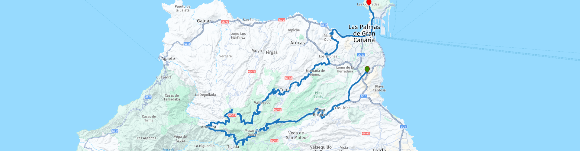
Roundtour from Las Palmas de Gran Canaria via Artenara and Teror

This route was brought to you by:
RouteXpert Jordi Honrubia MRA-RouteXpert
Last edit: 03-06-2025
 Route Summary
 Coloradas and offers an excellent option to explore the diversity of landscapes and the cultural richness of Gran
Canaria. Traveling through populated and unspoiled areas, you will notice the change in temperature as you ascend
more than 1,500 meters above sea level.
Overall, I give this beautiful route a 4 star rating.
 Share this route


Animation

Verdict


Duration
8h 8m

Mode of travel
Car or motorcycle

Distance
99.19 km

Countries

 RouteXpert Review
 The charming capital of this subtropical island can satisfy all cultural and culinary whims with its
stylish bars, restaurants and museums. Added to this is a calendar of lively festivals, a variety of
easy-access day trips, mountains and gigantic dunes. To discover the soul of the city, head to the
historic center of Vegueta, where colonial buildings line narrow cobbled streets.
The route starts in the south of the city and heads to the Santa Brígida neighborhood.
Saint Brigid:
The Santa Brígida neighborhood sits on a beautiful fertile plain populated with fruit trees and vineyards.
But there are also large areas of native plants, such as the holy pine or the strawberry tree, as well as beautiful
palm groves that adorn the residential areas. The surroundings of Santa Brígida also offer spectacular landscapes and
places of archaeological interest, such as the valley of Angostura, the caves of the Canarios and the Frailes, excavated
on the Caldereta volcano, or Los Silos.
You will pass by the hermitage dedicated to the devotion of San José de las Vegas and María, created in 1711 and rebuilt in 1939.
on the foundations of the old oratory.
You can visit the Casa del Vino Museum, which allows visitors to enter a sensorial world with activities
traditional centuries-old.
Leaving Santa Brígida, the road narrows and winds as you head towards the interior of the island with
some great views on the way to Cruz de Tejeda.
Cross of Tejeda:
Cruz de Tejeda, a sombre greenish-grey stone cross carved into a mountain pass at 1,580 m (5,184 ft)
above sea level, which marks the geographical center of Gran Canaria.
At this popular tourist attraction, you will find lively restaurants and bars, shops selling souvenirs and other
local specialties, including excellent honey, and a man who offers donkey rides to children. This is a
nice place to sit, relax and enjoy a cup of coffee. The nearby town of Tejeda is the second most
small island and is surrounded by terraced corn fields, orchards and vegetable crops and is located about
1000 m (3281 ft) above sea level. It is located on the slopes of a crater and has many remains
archaeological sites, such as tombs, caves, rock carvings and paintings. Without the rise of tourism in this area, this town
It would have been deserted long ago, as it is not possible to live on agricultural crops alone on this arid land.
Artenara is the highest town in Gran Canaria and is located on a giant natural balcony surrounded by the steep slopes
ridges and valleys of the Gran Canaria Biosphere Reserve. The Spanish writer Unamuno described the terrain
surrounding like a "petrified storm" and the views towards the iconic Roque Nublo and the Roque Bentaiga, once
sacred to the pre-Hispanic peoples of the island, are spectacular. Artenara is a quiet mountain village and
perfect for taking a break from the bustling resorts and coastal towns of the island. I have suggested a stop
to eat here at the bar restaurant La Majada, where I recommend the papas arrugadas, a traditional potato dish
boiled fish eaten in the Canary Islands. It is usually served with a chili and garlic sauce, called mojo rojo, or as a
accompaniment to meat dishes.
La Atalaya Viewpoint:
From this place you can see the hamlets of Las Cuevas, Caidero and Chajunco. After observing these carefully
neighborhoods, we can deduce that we are in a troglodyte village, where most of the neighbors live in
modern caves that are cool in summer and warm in winter. We also see that the village is in the middle of
pine forests. Without moving from the spot, we can observe the mass of the Tamadaba pine forest and the silhouette of Mount Teide in Tenerife.
There is also a beautiful panoramic view of the town centre, as well as La Cilla Mountain, on the summit of which is
the Sacred Heart of Jesus.
At the Mirador de La Atalaya there are two sculptures, inaugurated in 2007, dedicated to environmental workers.
which made possible the title of World Biosphere Reserve, awarded by UNESCO on June 29, 2005:
Foresta, which evokes the pine forest, and Prótego, which represents the coastal and midland landscape.
Viewpoint of the Gáldar Pine Observatory:
This place, called La Redonda, where the boundaries of the municipalities of Moya, Santa María de Guía and
Gáldar. SpanishThis place is notable for the centuries-old Canary Island pines that give it its name. From here you can see a
wide panoramic view of the north and west of Gran Canaria. The summit gives way to the midlands with a mosaic landscape
where, towards the north, the human presence becomes increasingly evident as we approach the coast.
At our feet is the Caldera de los Pinos de Gáldar, a volcanic crater belonging to the oldest volcanic cycle
recent in the construction of Gran Canaria, like the Montañón Negro volcano, located to the east. They are two peaks
twins with an estimated age of 3,000 years.
The route slowly descends until reaching the historic city of Teror at 543m.
Terror:
A place of pilgrimage par excellence for more than five centuries, the city of Teror has great symbolism
for the islanders by housing the Basilica of the Virgin of the Pine. Our Lady of the Pines is the patron saint of the Diocese of
Canary Islands and a religious reference for generations of Canarians. Considered one of the most beautiful villages in
the island, don't leave Gran Canaria without visiting the cobbled streets of its old town decorated with balconies
traditional, the Plaza de Nuestra Señora de los Pinos or the Basilica, declared a national historical-artistic monument and
Cultural Interest Site. You cannot visit Teror without taking a look at its Basilica. It stands next to the Plaza de Nuestra Señora de la Asunción.
Señora del Pino and its construction began in 1767 although it has been restored on several occasions since then,
between 1968 and 1969.
The last stretch of the route continues downhill and offers great views of the coast as you approach the
La Isleta peninsula and at the end of the route in Las Coloradas.
The Coloradas:
From here you can enjoy the best views of the sunsets over the Confital Bay, which are wonderful.
The Las Coloradas neighborhood is a neighborhood integrated into the Puerto-Canteras district of the city of Las Palmas de Gran Canaria.
Canaria but away from its hustle and bustle, as it is located in the heart of a protected area of the La Canary Peninsula.
Islet.


 Links
Links  Usage
Usage Want to download this route?
You can download the route for free without MyRoute-app account. To do so, open the route and click 'save as'. Want to edit this route?
No problem, start by opening the route. Follow the tutorial and create your personal MyRoute-app account. After registration, your trial starts automatically.  Disclaimer
Use of this GPS route is at your own expense and risk. The route has been carefully composed and checked by a MyRoute-app accredited RouteXpert for use on TomTom, Garmin and MyRoute-app Navigation.
Changes may nevertheless have occurred due to changed circumstances, road diversions or seasonal closures. We therefore recommend checking each route before use.
Preferably use the route track in your navigation system. More information about the use of MyRoute-app can be found on the website under 'Community' or 'Academy'.

Canary Islands
About this region
The Canary Islands (; Spanish: Canarias, pronounced [kaˈnaɾjas]), also known informally as the Canaries, is a Spanish archipelago in the Atlantic Ocean, in a region known as Macaronesia. At their closest point to the African mainland, they are 100 kilometres (62 miles) west of Morocco. They are the southernmost of the autonomous communities of Spain, and are located in the African Tectonic Plate. The archipelago is economically and politically European, and is part of the European Union.The eight main islands are (from largest to smallest in area) Tenerife, Fuerteventura, Gran Canaria, Lanzarote, La Palma, La Gomera, El Hierro and La Graciosa. The archipelago includes many smaller islands and islets, including Alegranza, Isla de Lobos, Montaña Clara, Roque del Oeste, and Roque del Este. It also includes a number of rocks, including those of Salmor, Fasnia, Bonanza, Garachico, and Anaga. In ancient times, the island chain was often referred to as "the Fortunate Isles". The Canary Islands are the southernmost region of Spain, and the largest and most populous archipelago of Macaronesia. Because of their location, the Canary Islands have historically been considered a bridge between the four continents of Africa, North America, South America, and Europe.In 2019, the Canary Islands had a population of 2,153,389, with a density of 287.39 inhabitants per km2, making it the eighth most populous autonomous community of Spain. The population is mostly concentrated in the two capital islands: around 43% on the island of Tenerife and 40% on the island of Gran Canaria.
The Canary Islands, especially Tenerife, Gran Canaria, Fuerteventura, and Lanzarote, are a major tourist destination, with over 12 million visitors per year. This is due to their beaches, tropical to subtropical climate, and important natural attractions, especially Maspalomas in Gran Canaria, Teide National Park, and Mount Teide (a World Heritage Site) in Tenerife. Mount Teide is the highest peak in Spain and the third tallest volcano in the world, measured from its base on the ocean floor. The islands have warm summers and winters warm enough for the climate to be technically tropical at sea level. The amount of precipitation and the level of maritime moderation vary depending on location and elevation. The archipelago includes green areas as well as desert areas. The islands’ high mountains are ideal for astronomical observation, because they lie above the temperature inversion layer. As a result, the archipelago boasts two professional observatories: Teide Observatory on the island of Tenerife, and Roque de los Muchachos Observatory on the island of La Palma.In 1927, the Province of Canary Islands was split into two provinces. In 1982, the autonomous community of the Canary Islands was established. The cities of Santa Cruz de Tenerife and Las Palmas de Gran Canaria are, jointly, the capital of the islands. Those cities are also, respectively, the capitals of the provinces of Santa Cruz de Tenerife and Las Palmas. Las Palmas de Gran Canaria has been the largest city in the Canaries since 1768, except for a brief period in the 1910s. Between the 1833 territorial division of Spain and 1927, Santa Cruz de Tenerife was the sole capital of the Canary Islands. In 1927, it was ordered by decree that the capital of the Canary Islands would be shared between two cities, and this arrangement persists to the present day. The third largest city in the Canary Islands is San Cristóbal de La Laguna (a World Heritage Site) on Tenerife. This city is also home to the Consejo Consultivo de Canarias, which is the supreme consultative body of the Canary Islands.During the Age of Sail, the Canaries were the main stopover for Spanish galleons on their way to the Americas, which sailed that far south in order to catch the prevailing northeasterly trade winds.
Read more on Wikipedia
The Canary Islands, especially Tenerife, Gran Canaria, Fuerteventura, and Lanzarote, are a major tourist destination, with over 12 million visitors per year. This is due to their beaches, tropical to subtropical climate, and important natural attractions, especially Maspalomas in Gran Canaria, Teide National Park, and Mount Teide (a World Heritage Site) in Tenerife. Mount Teide is the highest peak in Spain and the third tallest volcano in the world, measured from its base on the ocean floor. The islands have warm summers and winters warm enough for the climate to be technically tropical at sea level. The amount of precipitation and the level of maritime moderation vary depending on location and elevation. The archipelago includes green areas as well as desert areas. The islands’ high mountains are ideal for astronomical observation, because they lie above the temperature inversion layer. As a result, the archipelago boasts two professional observatories: Teide Observatory on the island of Tenerife, and Roque de los Muchachos Observatory on the island of La Palma.In 1927, the Province of Canary Islands was split into two provinces. In 1982, the autonomous community of the Canary Islands was established. The cities of Santa Cruz de Tenerife and Las Palmas de Gran Canaria are, jointly, the capital of the islands. Those cities are also, respectively, the capitals of the provinces of Santa Cruz de Tenerife and Las Palmas. Las Palmas de Gran Canaria has been the largest city in the Canaries since 1768, except for a brief period in the 1910s. Between the 1833 territorial division of Spain and 1927, Santa Cruz de Tenerife was the sole capital of the Canary Islands. In 1927, it was ordered by decree that the capital of the Canary Islands would be shared between two cities, and this arrangement persists to the present day. The third largest city in the Canary Islands is San Cristóbal de La Laguna (a World Heritage Site) on Tenerife. This city is also home to the Consejo Consultivo de Canarias, which is the supreme consultative body of the Canary Islands.During the Age of Sail, the Canaries were the main stopover for Spanish galleons on their way to the Americas, which sailed that far south in order to catch the prevailing northeasterly trade winds.
View region
 Statistics
  8
8Amount of RX reviews (Canary Islands)
 17297
17297Amount of visitors (Canary Islands)
 395
395Amount of downloads (Canary Islands)
 Route Collections in this region
 Exploring the magnificent roads of Gran Canaria in three days
Nog een weekje vakantie tegoed? En het snertweer zat? Op vier uur vliegen is het, in tegenstelling tot het wisselvallige Nederlandse weer, altijd zomer. En Gran Canaria kan dan wel bekend staan om de massa's zonaanbidders, het blijkt ook een waar walhalla voor de motorrijder!
Deze drie routes zijn prima in één weekend of midweek te rijden. Ze brengen je naar alle hoeken van het eiland waar het maar enigszins interessant is om te rijden. En laten we eerlijk zijn, dat is bijna het hele eiland! Laat je overweldigen door de fantastische krullende wegen, voorzien van strak asfalt, die over het eiland zijn aangelegd, laat je verrassen door de verborgen schatten die aan het massatoerisme voorbij gaan.
Op het eiland zijn meerdere verhuurders van motoren aanwezig waaronder Motor Rental Bike en Pic Y Poc. Voor het meest actuele aanbod en prijzen schiet je een zoekopdracht in bij Google, dan ben je vrijwel zeker dat de data niet verouderd is.
Per route worden in de review enkele bezienswaardigheden besproken. Deze vertellen vaak iets over de geschiedenis van het gebied waarin je rijdt. Leuke weetjes, best leerzaam. Het staat je geheel vrij om deze bezienswaardigheden te bezoeken, je kunt uiteraard ook je eigen interessante punten bepalen.
Maar het belangrijkste waar je waarschijnlijk voor bent afgereisd naar dit gebied, is het geweldige rijden en het schitterende weer. En zoals hierboven al is gezegd, je bevindt je in een waar motorparadijs waarin het fantastisch sturen is!
De routes van deze collectie:
Roundtour Gran Canaria day 1 West - 223km
Roundtour Gran Canaria day 2 North-East - 191km
Roundtour Gran Canaria day 3 South - 245km
Heel veel plezier bij het rijden van deze routes!
View Route Collection