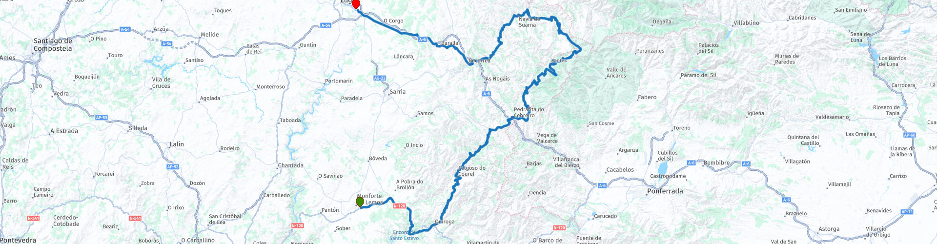
The Ribera Sacra region and Los Ancares to Lugo

This route was brought to you by:
RouteXpert Jordi Honrubia MRA-RouteXpert
Last edit: 14-02-2025
 Route Summary
 This route is a continuation of the magical Ribeira Sacra, now entering the wild heart of the Ancares. Get ready for a feast of the senses: winding roads that hug mountains, viewpoints that will leave you breathless and authentic villages that seem straight out of a storybook.
The exuberant nature of the Ancares will envelop you at every turn, giving you landscapes of breathtaking beauty. The leafy forests, crystal-clear rivers and steep peaks will make you feel in complete communion with nature. And if you are a lover of gastronomy, this route is your paradise: the meats and steaks of the area are a true delight for the palate.
It is an itinerary for the senses with dream roads that will enjoy driving along narrow, winding roads that will take you to hidden places full of charm.
With spectacular viewpoints that invite you to stop at the numerous viewpoints to contemplate unforgettable panoramic views of mountains, valleys and rivers.
Its villages with soul will make you discover the authenticity of the villages of the Ancares, where time seems to have stopped. And its high-altitude gastronomy that will delight you with the delicacies of the area, especially the meats and steaks, which will leave you wanting more.
This route, due to its combination of nature, culture and gastronomy, deserves and I give it 5 stars. It is a unique experience for lovers of road trips and the natural beauty of Galicia."
 Share this route


Animation

Verdict


Duration
7h 49m

Mode of travel
Car or motorcycle

Distance
244.28 km

Countries

 RouteXpert Review
 We will leave Monforte de Lemos after having enjoyed visiting and resting in its parador.
Along this route, you will discover ancient monasteries, Romanesque bridges and castles that tell stories of centuries past. In addition, you will be able to taste local products in traditional restaurants, where Galician gastronomy reaches its maximum expression.
Montforte de Lemos:
Monforte de Lemos, with its Parador as a starting point, invites you to explore one of the most authentic corners of Galicia. The road that connects this town to Ribera Sacra and Los Ancares, which is a true treasure for lovers of history, culture and good food, is a municipality in the south of the province of Lugo (Galicia). The capital of the Terra de Lemos region and the Ribeira Sacra, it is the largest population centre in the province after Lugo.
The municipality occupies a valley between the Miño and Sil rivers and the city is crossed by the Cabe river. With an area of almost 200 km2 and 300 metres above sea level, Monforte de Lemos has always been seen as the natural entrance to Galicia from Castile.
On the N-120 road that takes us to the villages of the Quiroga valley, we will pass by some Miradors where we will want to make a stop until we reach Quiroga.
Quiroga:
Quiroga is bordered to the north by Folgoso do Caurel, to the south by Ribas de Sil and A Pobra de Trives, to the east by La Rúa and Vilamartín de Valdeorras and to the west by A Pobra do Brollón.
To access this beautiful corner of Galician geography, we can do so by the N-120 road (Vigo-Logroño).
Here you will find two museums, one Geological and one Ethnographic.
The Geological Museum of Quiroga is one of the pillars of the Montañas do Courel Geopark and is part of its network of museums and interpretation centres, such as the Devesa da Rogueira Nature Classroom, the Covas de Meiraos interpretation centre and the Ribas de Sil gold mining interpretation centre. It is also the first Galician museum dedicated entirely to the interpretation of geological heritage; it was inaugurated in December 2011 and expanded in September 2020.
The Ethnographic Museum currently houses the ethnographic collection of our Museum, made up of just over 1,000 pieces collected in the territory of the Montañas do Courel UNESCO Global Geopark, which brings together the municipalities of Folgoso do Courel, Ribas de Sil and Quiroga, and is one of the most complete and interesting ethnographic collections in Galicia.
The contents of the Quiroga Ethnographic Museum are related, on the one hand, to the four typical products of the Courel Mountains Geopark: wine, chestnut, oil and honey; on the other, to the four essential materials for the development of life in this environment: stone, iron, wood and fabrics.
Passing Quiroga we will continue to see viewpoints such as the Campodola Viewpoint.
The fabulous Serra do Courel is one of those places in Galicia that should obtain the highest degree of protection to achieve the preservation of all its natural, cultural and archaeological values.
This mountain range is a wonder for the senses, perhaps one of the most undervalued places in Galicia taking into account its exceptional values. Fortunately, it is currently trying to gain momentum thanks to its inclusion as a UNESCO World Geopark under the name of "Montañas do Courel".
Mirador Folgoso do Courel:
One of the best viewpoints in the O Courel area is located at the foot of the LU-651 road in Vilamor. It has a parking area, a sign and a wooden railing to enjoy the view of the mountains.
Castro de la Torre:
It has a good number of castrexo settlements arranged along the top of this beautiful mountain range. Most of them are located on the top of the peaks, choosing those that had the greatest defensive features. The Romans searched for minerals in these areas and therefore almost all the castros have a high degree of Romanization since in the time of Roman domination these castros were related to the mines.
Its toponym is the same as another site in the place of Pacio, near Pedrafita, which is located in some mountains called Monte da Torre. That is why this is sometimes also called Torre do Castro and on some topographic maps it is called that. It is located in a privileged location, at 761, dominating part of the valley of the Lor River. It contains reconstructed quadrangular constructions typical of the Roman conquerors of the 1st and 4th centuries AD.
Alto de San Roque:
The monument to the pilgrim at Alto de San Roque (altitude 1270 m), a work by the Galician sculptor José María Acuña, is a statue placed in 1993 and located in Pedrafita do Cebreiro (Lugo). It is one of the most emblematic points of the French Way, the route that runs through the peninsula from east to west, starting in Roncesvalles and ending in Santiago de Compostela. We will find it while walking the O Cebreiro - Triacastela stage
We will find the splendid statue of the pilgrim after crossing O Cebreiro and Alto de Poio, after which we still have a good climb. The monument at Alto de San Roque invites us to stop on our way to Triacastela to rest, enjoy the incredible mountain landscape that we will find and take advantage of the opportunity to take photos, if there is not too much fog.
The pilgrim monument is one of the most repeated photos of the Camino de Santiago, with a special value if it has snowed heavily when we pass by, since it seems that we see the walker fighting against the elements.
El Cebrero:
Although it is only a small village in the municipality of Pedrafita do Cebreiro (just over 1,000 inhabitants), in the region of Los Ancares, O Cebreiro is an invaluable heritage of the Camino de Santiago, both medieval and recent. It is the first town on the French Way in Galicia, very attractive for its typical pallozas and its pre-Romanesque church from the 9th century. The foundation of this enclave dates back to approximately the year 863, around its hostel to shelter pilgrims after the discovery of the tomb of the Apostle.
In El Cebrero, history is tied to the land, like ivy to the rough rectangular stone bell tower, in a solid and primitive Romanesque style. The Celtic pallozas are still inhabited there, now converted into an ethnographic museum and a refuge for walkers.
Pedrafita de Cebrero:
The history of this municipality is strongly influenced by its importance on the Camino de Santiago. Its role as a crossing point for the Jacobean route and other routes marked its local history.
Pedrafita do Cebreiro was part of the itinerary of the Roman roads, such as the one that led to the interior of ancient Galicia from Astorga through Triacastela. In the Middle Ages, it gave way to the French Way to Santiago and to a Royal Road. In the 19th century, it became part of the N-VI, the first modern access road from the plateau to Galicia. Today, Pedrafita do Cebreiro is the entrance to Galicia of the French Way, the N-VI and the A-6. All this, together with the Miracle of the Holy Grail, which took place in O Cebreiro, made this municipality a mandatory pilgrimage site for centuries.
After Pedrafita we have a road with many winding curves and beautiful views that takes us to the Ancares Lucenses Biosphere Reserve where, from the top of its mountains, we can see the entire reserve.
Ancares Lucenses Biosphere Reserve:
Biosphere Reserves are territories whose objective is to harmonize the conservation of biological and cultural diversity and economic and social development through the relationship of people with nature.
They are established on ecologically representative areas or areas of unique value, in terrestrial, coastal and marine environments, in which the integration of the human population and its activities with conservation are essential.
It extends over 53,664 hectares of the eastern mountains of Lugo, covering the municipalities of Cervantes, Navia de Suarna and Becerreá. It was declared in 2006.
The Reserve forms a territory where the biodiversity of ecosystems is conditioned by its altitudinal contrasts of up to 1,600 metres between its highest elevations and its narrow river valleys such as the Navia, Ser or Rao.
It has been the abrupt orography of the environment that has traditionally made access to these lands difficult and which, together with its low population density, has favoured the conservation of its landscapes and the existence of places where time seems to pass at its own pace.
As regards the most characteristic habitats of the Reserve, the forest masses of species such as chestnuts, oaks, birches, hazelnuts, rowans, holly and yews stand out. Particularly unique are the beech forests such as that of A Pintinidoira, the holm oak grove of Cruzul and the chestnut grove of Agüeira. The Reserve also has areas of dry heaths and brooms that represent the scrubland zones.
The preservation of natural spaces has allowed the Reserve to be a territory with conditions that favour the presence of game species, wolf populations and species in serious danger of extinction such as the brown bear, which has been seen in transit in some places of the Reserve. In the past, Os Ancares was also the refuge of the capercaillie, a bird that due to its high vulnerability is considered extinct in the area.
Within the scope of the Biosphere Reserve are included other areas of the Galician Natura Network such as the ZEC Ancares- Courel or the Cruzul- Agüeira natural space. In addition, Os Ancares is a National Hunting Reserve, Brown Bear Protection Zone, Picturesque Landscape and Special Protection Zone for Birds.
The cultural wealth of the territory is deduced from the condition of Os Ancares as a witness to the passage of entire civilisations since Prehistory. Later, the legacy of Romanisation will take us back to the heritage elements linked to Roman gold mining, such as the castro of Santa María de Cervantes, and to the presence of an important road infrastructure such as the Roman Road XIX of the Antonine Itinerary. There are also impressive vestiges from the Middle Ages, such as the castle of Doiras, the scene of legends that tell us about enchanted princesses.
Piornedo:
In the heart of Os Ancares and almost touching the province of León is the village of Piornedo, belonging to the municipality of Cervantes. This small village is situated at an altitude of 1100 metres on the side of a mountain, at the top of the valley formed by the Rego Veiga Cimeira which falls towards the great valley of Ser.
The peculiarity of this small village of Piornedo lies in the fact that the structure of its houses has been maintained over the centuries without hardly changing, giving the appearance of a pre-Roman village. Its houses, the pallozas, are circular or oval and their roofing is based on rye straw, heather or "piorno or codeso" (adenocarpus complicatus).
This interlaced material formed a roof with great waterproof and thermal properties. The height of the walls varied between one and a half metres and two metres and they had no other opening than small ventilation holes. These are the most primitive dwellings in the north-west of the peninsula and it is said that their predecessors were the houses of the castrexos settlements. Until recently, their area of influence extended from Navia de Suarna to O Courel. Today, their presence is limited to small areas of the Cervantes mountains. The plan of the palloza is delimited by an elliptical wall, formed by two circles of different radii joined by two straight lines tangent to them. The dimensions vary between 12 and 15 metres in length for the major axis and between 5 and 8 for the minor.
The whole of the village of Piornedo is catalogued as BIC and is considered a Historic-Artistic Site. There are several pallozas fitted out as house-museums and some were even inhabited until the 1970s. In Piornedo we would like to highlight the fountain located at the entrance to the village and which has an inscription that says "It was built in 1787. Long live Piornedo." There is another fountain towards the top of Piornedo where we will see an anthropomorphic motif of possible secular origin. Nearby we have the small chapel of San Bartolomeu, of baroque design. From Piornedo there are several routes that run through Os Ancares, such as the one to the neighbouring peak of Mustallar which runs through its glacial valley and takes us to the mountains of León. Piornedo and the entire area of influence must be one of the greatest tourist attractions in Galicia, for its history, architecture and nature.
Balouta viewpoint with the Puerto de Ancares:
Porto de Ancares is a reference point in these mountains. The point of union between León and Lugo, with its 1648 metres of altitude it is located in the middle of the mountain range, connecting valleys and mountains, villages and mountains.
The climb from Balouta overcomes the steep slope characteristic of the Ancares orography. At the top of the pass, the views on both sides are impressive: to the north, from the Balouta viewing point, a wide panoramic view of the peaceful valley that contrasts with the steep peaks; to the south, the Ancares valley, already in León, descends endlessly. At the top, the wind from the mountains, snowfall in winter and a special light that is only found in passes like this.
Also here, the Alto del Mirador de Balouta (1713 m) is a mountain belonging to Sierra Bruteira, a small ridge that links Pico Miravalles with Puerto de Ancares. It is located between the latter and El Gamotal, rising above the Arneiroso and Balouta Valleys.
Navia de Suarna:
The Navia de Suarna Castle, a construction made of slate slabs and linked to the Counts of Altamira, is built on rocks and preserves part of the primitive walls and towers. The existing documents about the fortress show that it already existed in the 11th century, although it was later destroyed by the Irmandiña Revolution and rebuilt four centuries later, losing its military character when it was rebuilt. It is thought that it was originally created to defend the Old Bridge, a civil construction that crosses the Navia River. The current building dates from the 14th century, with a previous vault from the 13th century.
Built in the 14th century but has a previous vault, from the 13th century. It is made of slate slab masonry. It has a pointed arch with a span of 21 metres and a height of 13 metres, it is very high and crosses the river with a domed road, with a 16% gradient, which curves at the ends. High and solid protective walls. Reinforcement was applied to prevent it from collapsing.
The brañas, natural spaces provided with water, were used at certain times of the year for cattle to graze. Those of Pan do Zarco are the best preserved in the Os Ancares mountain range. In the past, cattle were moved to these areas for about 4 months a year and the whole family moved there to live. The plains were used, in addition to pasture, to sow cereals, an important element of the diet of the population of the area.
Leaving from this wonderful town Navia de Suarna we head along the Navia River until finishing the Route in Lugo.


 Links
Links  Usage
Usage Want to download this route?
You can download the route for free without MyRoute-app account. To do so, open the route and click 'save as'. Want to edit this route?
No problem, start by opening the route. Follow the tutorial and create your personal MyRoute-app account. After registration, your trial starts automatically.  Disclaimer
Use of this GPS route is at your own expense and risk. The route has been carefully composed and checked by a MyRoute-app accredited RouteXpert for use on TomTom, Garmin and MyRoute-app Navigation.
Changes may nevertheless have occurred due to changed circumstances, road diversions or seasonal closures. We therefore recommend checking each route before use.
Preferably use the route track in your navigation system. More information about the use of MyRoute-app can be found on the website under 'Community' or 'Academy'.
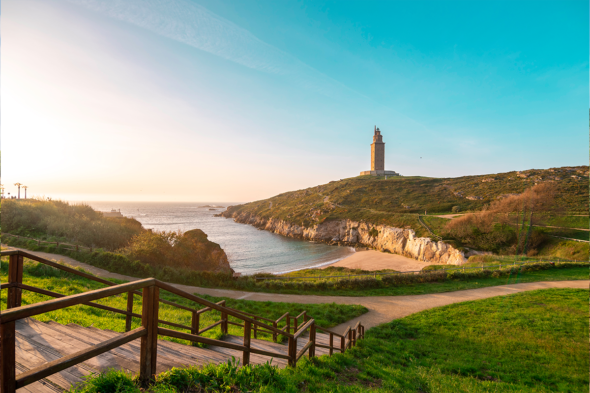
Galicia
About this region
Galicia (; Galician: Galicia [ɡaˈliθjɐ] or Galiza [ɡaˈliθɐ]; Spanish: Galicia, Portuguese: Galiza) is an autonomous community of Spain and historic nationality under Spanish law. Located in the northwest Iberian Peninsula, it includes the provinces of A Coruña, Lugo, Ourense and Pontevedra.
Galicia is located in Atlantic Europe. It is bordered by Portugal to the south, the Spanish autonomous communities of Castile and León and Asturias to the east, the Atlantic Ocean to the west, and the Cantabrian Sea to the north. It had a population of 2,701,743 in 2018 and a total area of 29,574 km2 (11,419 sq mi). Galicia has over 1,660 km (1,030 mi) of coastline, including its offshore islands and islets, among them Cíes Islands, Ons, Sálvora, Cortegada Island, which together form the Atlantic Islands of Galicia National Park, and the largest and most populated, A Illa de Arousa.
The area now called Galicia was first inhabited by humans during the Middle Paleolithic period, and takes its name from the Gallaeci, the Celtic people living north of the Douro River during the last millennium BC. Galicia was incorporated into the Roman Empire at the end of the Cantabrian Wars in 19 BC, and was made a Roman province in the 3rd century AD. In 410, the Germanic Suebi established a kingdom with its capital in Braga (Portugal); this kingdom was incorporated into that of the Visigoths in 585. In 711, the Islamic Umayyad Caliphate invaded the Iberian Peninsula conquering the Visigoth kingdom of Hispania by 718, but soon Galicia was incorporated into the Christian kingdom of Asturias by 740. During the Middle Ages, the kingdom of Galicia was occasionally ruled by its own kings, but most of the time it was leagued to the kingdom of Leon and later to that of Castile, while maintaining its own legal and customary practices and culture. From the 13th century on, the kings of Castile, as kings of Galicia, appointed an Adiantado-mór, whose attributions passed to the Governor and Captain General of the Kingdom of Galiza from the last years of the 15th century. The Governor also presided the Real Audiencia do Reino de Galicia, a royal tribunal and government body. From the 16th century, the representation and voice of the kingdom was held by an assembly of deputies and representatives of the cities of the kingdom, the Cortes or Junta of the Kingdom of Galicia. This institution was forcibly discontinued in 1833 when the kingdom was divided into four administrative provinces with no legal mutual links. During the 19th and 20th centuries, demand grew for self-government and for the recognition of the culture of Galicia. This resulted in the Statute of Autonomy of 1936, soon frustrated by Franco's coup d'etat and subsequent long dictatorship. After democracy was restored the legislature passed the Statute of Autonomy of 1981, approved in referendum and currently in force, providing Galicia with self-government.
The interior of Galicia is characterized by a hilly landscape; mountain ranges rise to 2,000 m (6,600 ft) in the east and south. The coastal areas are mostly an alternate series of rias and beaches. The climate of Galicia is usually temperate and rainy, with markedly drier summers; it is usually classified as Oceanic. Its topographic and climatic conditions have made animal husbandry and farming the primary source of Galicia's wealth for most of its history, allowing for a relative high density of population. With the exception of shipbuilding and food processing, Galicia was based on a farming and fishing economy until after the mid-20th century, when it began to industrialize. In 2018, the nominal gross domestic product was €62,900 million, with a nominal GDP per capita of €23,300. Galicia is characterised, unlike other Spanish regions, by the absence of a metropolis dominating the territory. Indeed, the urban network is made up of 7 main cities (the four provincial capitals A Coruña, Pontevedra, Ourense and Lugo, the political capital Santiago de Compostela and the industrial cities Vigo and Ferrol and other small towns. The population is largely concentrated in two main areas: from Ferrol to A Coruña in the northern coast, and in the Rías Baixas region in the southwest, including the cities of Vigo, Pontevedra, and the interior city of Santiago de Compostela. There are smaller populations around the interior cities of Lugo and Ourense. The political capital is Santiago de Compostela, in the province of A Coruña. Vigo, in the province of Pontevedra, is the largest municipality in Galicia, while A Coruña is the largest Galician city. · .Two languages are official and widely used today in Galicia: the native Galician, a Romance language closely related to Portuguese with which it shares the Galician-Portuguese medieval literature; and Spanish, usually called Castilian. While most Galicians are bilingual, a 2013 survey reported that 51% of the Galician population spoke Galician most often on a day-to-day basis, while 48% most often used Spanish.
Read more on Wikipedia
Galicia is located in Atlantic Europe. It is bordered by Portugal to the south, the Spanish autonomous communities of Castile and León and Asturias to the east, the Atlantic Ocean to the west, and the Cantabrian Sea to the north. It had a population of 2,701,743 in 2018 and a total area of 29,574 km2 (11,419 sq mi). Galicia has over 1,660 km (1,030 mi) of coastline, including its offshore islands and islets, among them Cíes Islands, Ons, Sálvora, Cortegada Island, which together form the Atlantic Islands of Galicia National Park, and the largest and most populated, A Illa de Arousa.
The area now called Galicia was first inhabited by humans during the Middle Paleolithic period, and takes its name from the Gallaeci, the Celtic people living north of the Douro River during the last millennium BC. Galicia was incorporated into the Roman Empire at the end of the Cantabrian Wars in 19 BC, and was made a Roman province in the 3rd century AD. In 410, the Germanic Suebi established a kingdom with its capital in Braga (Portugal); this kingdom was incorporated into that of the Visigoths in 585. In 711, the Islamic Umayyad Caliphate invaded the Iberian Peninsula conquering the Visigoth kingdom of Hispania by 718, but soon Galicia was incorporated into the Christian kingdom of Asturias by 740. During the Middle Ages, the kingdom of Galicia was occasionally ruled by its own kings, but most of the time it was leagued to the kingdom of Leon and later to that of Castile, while maintaining its own legal and customary practices and culture. From the 13th century on, the kings of Castile, as kings of Galicia, appointed an Adiantado-mór, whose attributions passed to the Governor and Captain General of the Kingdom of Galiza from the last years of the 15th century. The Governor also presided the Real Audiencia do Reino de Galicia, a royal tribunal and government body. From the 16th century, the representation and voice of the kingdom was held by an assembly of deputies and representatives of the cities of the kingdom, the Cortes or Junta of the Kingdom of Galicia. This institution was forcibly discontinued in 1833 when the kingdom was divided into four administrative provinces with no legal mutual links. During the 19th and 20th centuries, demand grew for self-government and for the recognition of the culture of Galicia. This resulted in the Statute of Autonomy of 1936, soon frustrated by Franco's coup d'etat and subsequent long dictatorship. After democracy was restored the legislature passed the Statute of Autonomy of 1981, approved in referendum and currently in force, providing Galicia with self-government.
The interior of Galicia is characterized by a hilly landscape; mountain ranges rise to 2,000 m (6,600 ft) in the east and south. The coastal areas are mostly an alternate series of rias and beaches. The climate of Galicia is usually temperate and rainy, with markedly drier summers; it is usually classified as Oceanic. Its topographic and climatic conditions have made animal husbandry and farming the primary source of Galicia's wealth for most of its history, allowing for a relative high density of population. With the exception of shipbuilding and food processing, Galicia was based on a farming and fishing economy until after the mid-20th century, when it began to industrialize. In 2018, the nominal gross domestic product was €62,900 million, with a nominal GDP per capita of €23,300. Galicia is characterised, unlike other Spanish regions, by the absence of a metropolis dominating the territory. Indeed, the urban network is made up of 7 main cities (the four provincial capitals A Coruña, Pontevedra, Ourense and Lugo, the political capital Santiago de Compostela and the industrial cities Vigo and Ferrol and other small towns. The population is largely concentrated in two main areas: from Ferrol to A Coruña in the northern coast, and in the Rías Baixas region in the southwest, including the cities of Vigo, Pontevedra, and the interior city of Santiago de Compostela. There are smaller populations around the interior cities of Lugo and Ourense. The political capital is Santiago de Compostela, in the province of A Coruña. Vigo, in the province of Pontevedra, is the largest municipality in Galicia, while A Coruña is the largest Galician city. · .Two languages are official and widely used today in Galicia: the native Galician, a Romance language closely related to Portuguese with which it shares the Galician-Portuguese medieval literature; and Spanish, usually called Castilian. While most Galicians are bilingual, a 2013 survey reported that 51% of the Galician population spoke Galician most often on a day-to-day basis, while 48% most often used Spanish.
View region
 Statistics
  4
4Amount of RX reviews (Galicia)
 24562
24562Amount of visitors (Galicia)
 128
128Amount of downloads (Galicia)