MTG2 19 Vierzon La Chatre Bourganeuf Argentat

This route was brought to you by:
RouteXpert René Plücken (MRA Master)
Last edit: 12-02-2021
 Route Summary
 climate. It is not for nothing that you see so many motorcyclists there. My previous series of routes in France were based on the route descriptions from the Motortourgids France part 1 made by Bert Loorbach.
This route comes from Motortourgids France part 2 and the original name is "Driving routes to the West; Route description 3: from Loire to the eastern part of the Dordogne".
In Motorbike guide France part 2 a difference has been made between approach routes and trips in a certain area. The approach routes can also be used in combination with the routes from Motortourgids France part 1
The routes are sometimes slightly adjusted based on the tips that Bert Loorbach gives in his description, or because of a different place to spend the night, or to achieve the minimum length of 2 hours for the MRA Library. For each route there is a more detailed description in the review, including options to stay overnight or places of interest en route, which are also indicated with a POI and if possible with a short description
The route is made suitable for Garmin, TomTom, Harley-Davidson BoomBox 2019 and Navigation App, can be downloaded for free and without My-Route-app registration. To do this, first click on the 'Use route' button and then on 'Save as'.
 Share this route


Animation

Verdict


Duration
5h 35m

Mode of travel
Car or motorcycle

Distance
313.44 km

Countries

 RouteXpert Review
 This is the third of three approach routes to the West of France. and can be used as a starting route for one of the other routes in this area as they are described in the Motorbike Guides parts 1 and 2.
Beautiful touring through the countryside to the French west coast or towards lle d'Oléron. Nice to drive around all major cities on only D-roads that get along well. Ideal! This route from the Loire region is very nice as a return trip from one of the most popular destinations in France: the Dordogne (see part 1).
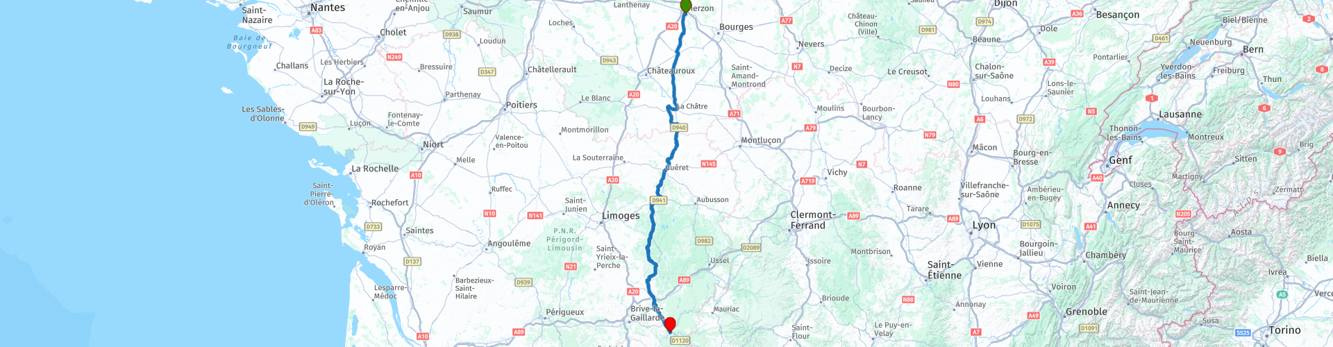
The ride starts in Vierzon, you drive more or less parallel to the highway, straight down. You can then enjoy the Berry and the Creuse, including the special Plateau de Millevaches in the National Nature Park Millevaches de Limousin, to finally arrive in Argentat.
Before the time comes, there are still a lot of miles to go! The Berry is a rural area, rural, quiet, but it is nice to drive on the rolling roads of the heart of rural France. Moreover, the Berry surprisingly offers a rich heritage of culture.
From Vierzon it goes south on the D918 in the direction of Issoudun, which you will quickly get around via the ring road. The next town is La Châtre (RP4), where the writer George Sand was inspired by the gloomy forests around the Indre. There is a museum dedicated to her where you can also see a large collection of stuffed birds.
A very special castle (it seems to come from a comic strip) is located here on a farmyard in the town of Sarzay. This is definitely worth a visit; Le Châteay de Sarzay (RP7), described by George Sand in her novel "Le Meunier d'Angibault", is a medieval castle from the 14th century that at the time had thirty-eight towers and three drawbridges and a man's home flanked by five round towers, moats and also a fortified chapel. A visit to it takes you more on your journey to the Middle Ages !.
After our visit to the Château we take the D41 to get back to the main route via Chassignolles.
When entering the Creuse valley at Guéret (RP9) you notice that the roads are winding. That will continue for a little while, because we are entering the transition from the flatter center to the considerably hilly south. Guéret is already a very old city, but unfortunately little old charm has been preserved. So we drive through the town again to the connection with D940.
After approximately 8 km you take the exit on the right to the D940a. This is a nicer and shorter winding road through a beautiful green hilly landscape to the next town of Bourganeuf (RP12). Here you can insert a lunch break.
Under Bourganeuf we enter, via the Millevaches Plateau, the Parc Naturel Régional de Millevaches (RP13) and Limousin. Located in the foothills of the Massif Central (314000 ha), this Nature Park consists of seven different areas: Vassivière, the Vienne valley, the Monédières, the Sources, the Courtine and the Creuse, the valleys of Haute-Corrèze and the plateau of Eygurande in Flayat. In this untouched and preserved area you will find the Millevaches plateau, the heaths of les Monédières and the peatlands of Bonnefond and Péret Bel Air. At Peyrat Le-Château lies the popular lake of Vassivière, but also the Creuse, the Vienne and the Vézère have their origins here.
From Eymoutíers (RP14) we take the smaller D roads to Chamberet (RP15) again. Here you start a very beautiful part full of nature, about 70 km long. At the picturesque Treígnac (RP16) you cross the Vézère. Argentat is our end station. This place is on the Dordogne and is a nice base for various beautiful trips (see also part 1).
The first part of this approach route to the Dordogne runs on a largely straight road, after the visit to the castle in Sharzay the road changes into a beautiful winding ribbon through a beautiful landscape. Along the way there are a number of sights and nice towns to visit. This route is therefore worth 3 *** stars.


 Links
Links  Usage
Usage Want to download this route?
You can download the route for free without MyRoute-app account. To do so, open the route and click 'save as'. Want to edit this route?
No problem, start by opening the route. Follow the tutorial and create your personal MyRoute-app account. After registration, your trial starts automatically.  Disclaimer
Use of this GPS route is at your own expense and risk. The route has been carefully composed and checked by a MyRoute-app accredited RouteXpert for use on TomTom, Garmin and MyRoute-app Navigation.
Changes may nevertheless have occurred due to changed circumstances, road diversions or seasonal closures. We therefore recommend checking each route before use.
Preferably use the route track in your navigation system. More information about the use of MyRoute-app can be found on the website under 'Community' or 'Academy'.