R19 Roundtour Sirkka to North Cape part 5

This route was brought to you by:
RouteXpert Arno van Lochem - RouteXpert
Last edit: 06-05-2021
 Route Summary
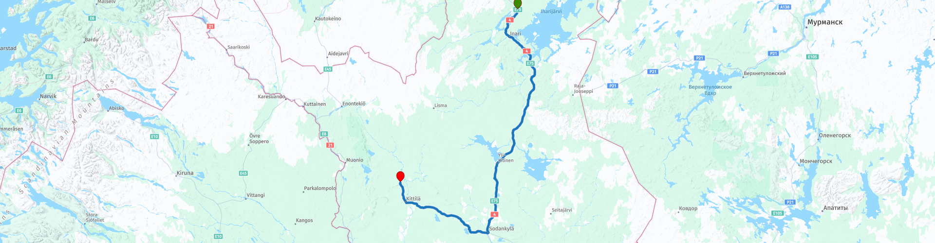
 You can also see this part as the last part of a 5-part tour from Sirkka to the North Cape.
The routes are easy for everyone to drive and are on well-paved roads. It may be necessary to take a single hairpin bend, but these are perfectly doable.
If there is a piece of gravel in the route, a warning will be given and, if possible, a detour will be indicated.
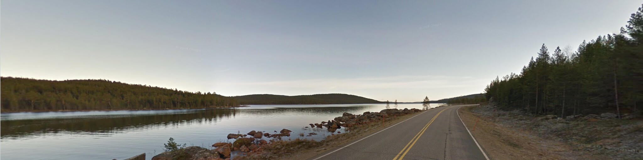
The route starts in Kaamanen. Along the way fantastic landscapes, lots, lots of water and beautiful views, making the road great. Nice to drive. After every turn a different fantastic view. Beautiful and interesting sights include the Sámi museum Siida, Bears Nest Stone and the Tankavaara Gold Museum.
There are not too many catering establishments, which is why it is better to ensure that you have something to eat and drink with you for the road.
The route is 330 kilometers long, a shorter route is indicated, but that means that you will drive more than 50 kilometers or gravel. Please note that this shorter route contains few facilities such as petrol stations or restaurants along the way. So make sure you have a well-filled tank and something to eat and drink on the go.
Beautiful rugged landscape, beautiful scenic views, tight roads and beautiful sights, hence the 4-star rating.
 Share this route


Animation

Verdict


Duration
7h 52m

Mode of travel
Car or motorcycle

Distance
331.74 km

Countries

 RouteXpert Review
 Of all western European countries, the Scandinavian countries probably have the most more or less untouched nature. In addition, they are countries that are easily accessible from the Netherlands. Norway is characterized by, among other things, the fjords and the Trollstigen known to many motorcyclists. And where Sweden is known as wide and peaceful, everyone knows Finland as the land of 1000 lakes. All in all, legitimate reasons to traverse this beautiful nature in the north of Europe by means of a number of routes.
The route starts at the hotel in Kaamanen. There is a gas station on site, so leaving with a full tank does not have to be a problem. A snack for on the go is also available in the local shop.
After more than 25 kilometers you drive along the Saamelaismuseo Siida. The museum consists of an inner part in which the life of the Sami is exhibited. The flora and fauna of Finnish Lapland are also exhibited here.
There is also a large outdoor exhibition. It shows the buildings that the Sami use or have used. Houses and all kinds of utensils, including bear traps and all kinds of boats. If you have not yet visited a Sámi museum in the past routes, this is one of your last chances, the museum has good reviews.
After a possible museum visit you have the choice to take a shorter one. You then drive through a very sparsely populated area where there is little to be found when it comes to petrol stations and / or catering establishments. It saves about 130 kilometers, but keep in mind that this road will turn into gravel at some point. The length of this piece of gravel is around 55 kilometers. Good to drive by the way.
Located in close proximity to Lake Myössäjärvi, about 25 kilometers north of Ivalo, is a bear's nest stone that makes a wonderful stop to visit. At the sight there is a cafeteria and souvenir shop, there is plenty of parking available. Climbing the stairs to this beautiful sight is a great exercise and unforgettable too.
The stairs come out next to a huge boulder, which has quite a few surprises to offer its visitors: in the corner of the boulder is a small entrance. The inside of this stone has been corroded by the melt water, the stone is hollow, naturally rustic and cozy, a wonderful nature stop for a geologist.
The stone is said to have gotten its name (bear's nest stone) from the fact that Lappalainen, lost in a snowstorm, encountered a bear. He came across this stone and went in for protection and fell asleep there. When he woke up, he realized that in that same cave was also the bear he was fleeing from. Fortunately, the bear did not wake up and the man was able to leave the cave after the storm subsided.
After driving about 130 kilometers you will pass Tankavaara. Tankavaara is a village and a tourist attraction in the municipality of Sodankylä. Tankavaara is famous for its gold exploration that started in the 1930s. Since the 1970s, the village has been a tourist attraction with a hotel, restaurant "Old Gold Prospector" and the Gold Prospector Museum.
The International Gold Museum presents the history of Finnish gold, as well as the history of the world's greatest gold rush. A display called Golden World tells the story of gold in more than 20 countries. The open-air museum is housed in several historic buildings and the courtyard is decorated with a large bronze statue of a gold digger by the artist Professor Ensio Seppänen. The museum's stone and mineral collection has more than 2,500 samples from around the world.
In Sodankyla the route passes one of the oldest wooden churches in Finland, the Sodankylän Vanha Kirkko. The church was built in 1689 at the expense of the Royal Majesty, Charles XI. Sodankylä Church was only the third church to be built in Lapland, after the churches of Inari and Kemijärvi. Sodankylä is located in the middle of these two places and the church was intended for the then inhabitants of the present areas Sodankylä, Kittilä, Pelkosenniemi and Savukoski.
Stylistically, the church represents the medieval church building tradition on the one hand and the Ostrobothnic tradition of wooden churches on the other. The church has a gable roof and no towers. The sacristy adjoins the north wall of the church like a protrusion, as does the vestibule on the west side. The interior is unlined and unpainted. The walls are reinforced with Ostrobothnian-type support chests. Interesting details include the water roof ridge crest and streamers, which represent a style layer dating back to the Middle Ages. The inner barrel vault dates back to 1703 and the shell is separated from the rest of the church by modest beetles. The church foyer was built at the end of the 18th century. The church can seat about 220 people. In the spirit of the 18th century, valuable people are buried under the church floor. The best preserved mummy is Abraham Cajander, the pastor's two-week-old son.
When you arrive in Kittilä you have the opportunity to visit two museums. First, here you will find the The Einari Junttila Art Museum. This museum is located in a house built by the artist in the 1930s. The native Kittilä artist Einari Junttila (1901-1975) is best known for his watercolors depicting the nature of Lapland. Opened in 1991, the museum showcases his art and home environment. The museum is owned and maintained by Einari Junttila's daughter, Terttu Junttila.
You will also find the Palso museum in this place. It includes the cottage and studio of Kalervo Palsa (1947-1987). The artist's father Hugo Palsa bought a small farm called Hyrynkangas in 1946 and it is one of the few surviving buildings in the church village of Kittilä that survived the devastation of the Lapland War. The museum is open from the beginning of June to the end of September,
Kalervo Palsa lived in the cottage with his parents and three brothers. Mother Hilja Kenttälä earned extra income for the family by selling liquor and sheltering men working in the area. At a young age, the existing courtyard became an important place for Kalervo Palsa, where he was allowed to write and paint his diary in peace. He called his bare studio Cloud Castle and Gethsemane. The last years of his life Palsa lived there alone, after the death of his mother and brother. On October 4, 1987, he died in his studio after contracting pneumonia.
The Palsa Museum in the center of Kittilä was opened on June 6, 2013. The house was uninhabited since the artist's death and has fallen into disrepair. The Kauko Sorjonen Foundation acquired Palsa buildings and furniture in 2011, and restoration work was carried out the following year. In connection with the work, the paintings on the walls of the studio in Gethsemane have also been preserved.
Afterwards you can enjoy a cup of coffee in one of the available coffee bars, so that you are ready for the last part of this route
The end point of this 330 km route is the Break Sokos Hotel Levi in Sirkka (Levi is the commercial name of Sirkka). This is a hotel in the center with its own parking garage (not free). Bar and restaurant are present again, so the debriefing while enjoying a beer is no problem here either. There is also a sauna.
There is a campsite signposted for campers near the end point: Kittilän lomamökit.
With this last part, the tour from Sirkka to the beautiful North Cape comes to an end. In the following parts you set course to the south. That's easier said than done, there is still a distance of more than 1,750 kilometers to cover before this 26-part tour comes to an end.
Have fun driving this route!


 Links
Links  Usage
Usage Want to download this route?
You can download the route for free without MyRoute-app account. To do so, open the route and click 'save as'. Want to edit this route?
No problem, start by opening the route. Follow the tutorial and create your personal MyRoute-app account. After registration, your trial starts automatically.  Disclaimer
Use of this GPS route is at your own expense and risk. The route has been carefully composed and checked by a MyRoute-app accredited RouteXpert for use on TomTom, Garmin and MyRoute-app Navigation.
Changes may nevertheless have occurred due to changed circumstances, road diversions or seasonal closures. We therefore recommend checking each route before use.
Preferably use the route track in your navigation system. More information about the use of MyRoute-app can be found on the website under 'Community' or 'Academy'.