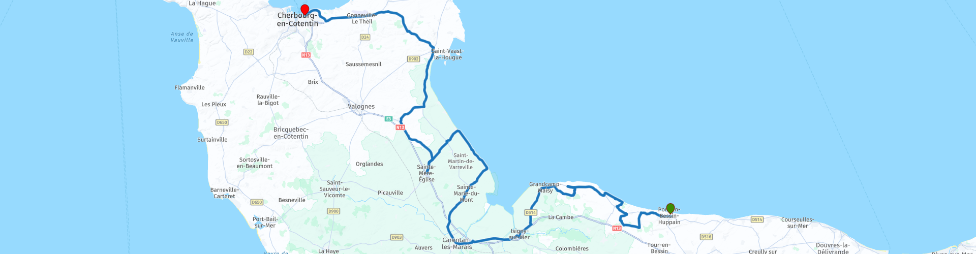
Port en Bessin to Cherbourg via Omaha and Utah beaches

This route was brought to you by:
RouteXpert Nick Carthew - (MRA Master)
Last edit: 23-12-2020
 Route Summary
 Rural and coastal roads with 2 short sections of motorway. Great sites to visit is why I have awarded 4**** stars for this route.
This is only a short route to enable you to reach the ferry port in time for returning to the UK, but there is much to see so don't become too distracted.
 Share this route


Animation

Verdict


Duration
2h 34m

Mode of travel
Car or motorcycle

Distance
134.82 km

Countries

 RouteXpert Review
 Just a short ride from your hotel will take you to Omaha Beach.
Omaha Beach is one of the two American landing areas in Normandy. The 29th Infantry Division and the 1st Infantry Division would be badly mauled in their assault; mined obstacles on the beach and mines in the bluffs, a shingle bank or sea wall to overcome, barbed wire, and concrete fortifications beyond. Today's beach has an art installation called Les Braves to commemorate the fallen. The Omaha Beach Museum can be found 250m inland from the roundabout. A link for their website is below this review.
Omaha Beach linked the U.S. and British beaches. It was a critical link between the Cotentin Peninsula, also known as the Cherbourg Peninsula, and the flat plain in front of Caen. Omaha was also the most restricted and heavily defended beach. For that reason, at least one veteran U.S. Division (lst Infantry Division) was tasked to land there. The terrain was difficult. Omaha beach was unlike any of the other assault beaches in Normandy. Its crescent curve and unusual assortment of bluffs, cliffs and draws were immediately recognizable from the sea. It was the most defensible beach chosen for D-Day; in fact, many planners did not believe it a likely place for a major landing. The high ground commanded all approaches to the beach from the sea and tidal flats. Moreover, any advance made by U.S. troops from the beach would be limited to narrow passages between the bluffs. Advances directly up the steep bluffs were difficult in the extreme. At its western end, the first wave of troops was all but wiped out, and succeeding waves piled up on the sea wall, paralysed for a time. This is why it was referred to as Bloody Omaha.
A little further along the coast is La Pointe du Hoc.
Pointe du Hoc, a strategic element of the Atlantic Wall, was stormed by Colonel Rudder's Rangers on the morning of Tuesday 6th of June 1944. it proved to be one of the toughest battles to be fought during the Normandy Landings: of the 225 Rangers that began the assault, only 90 were still fit to continue their fight for France's Liberation. It was a tough assault and a memorial is in place commemorating Colonel James E Rudder and his men.
The battle for Pointe du Hoc became of one the most heroic moments of the D-Day invasion. It was lionized by the legendary Hollywood film "The Longest Day" and by President Ronald Reagan, who stood on this hallowed ground to deliver one of his most famous speeches, extolling the bravery of the "Boys of Pointe du Hoc" on the 40th anniversary of the largest amphibious assault in the world's history. (see link below)
But a little more than 3 miles down the windswept Normandy coastline, an archaeological dig on a vast swath of farmland is starting to tell another story about what took place that day. A World War II artifact collector and historian accidentally stumbled upon a massive German artillery installation that was buried after the invasion. His discovery, along with a trove of declassified U.S. and British military documents, threatens to alter the narrative of Pointe du Hoc and its importance as a military objective during the D-Day invasion.
Why did the Americans completely bury the Maisy Battery? Perhaps your visit will reveal all! (see link below)
The route takes a big sweep inland now to circumnavigate the flat marshy land of the Douve river. There are opportunities to visit more D Day museums as you pass through the small rural town of Carentan. The town itself saw some heavy fighting and has plenty of stories to tell.
Head back to the coast now and Utah Beach.
Utah Beach was the codename for D-Day’s westernmost landing beach. Here the U.S. 4th Infantry Division came ashore with the task of establishing a bridgehead at the base of the Cotentin peninsula. This was an important assignment in the effort to seize the deep-water port of Cherbourg as quickly as possible. Five hours before the first seaborne landings, U.S. airborne troops were dropped behind the coastal defences. Fighting their way towards the beach, they cleared the enemy positions that threatened the Allied exit from the beaches. The paratroopers managed to prevent any significant counterattacks. The German strongpoint on the beach of La Madeleine was composed of various shelters and bunkers, a grenade launcher and four canons assigned to cover an antitank zone. These modest defences could not withstand the terrible air and naval bombardments of D-Day. They offered little resistance to the American assault forces, even though many units landed nearly 2.000 meters to the southeast from the original plan. At the end of the day, the assault was a total success, with relatively few American casualties. Utah Beach Museum tells the full story. (link below)
Onto the town of Sainte-Mère-Eglise.
During the Normandy invasion, 30 paratroopers landed in the town of Sainte-Mère-Eglise, including 20 on the church square. German soldiers hurled into the attack and a battle raged on for two days. U.S. forces’ resistance was put to the test.
Paratrooper private John Steele of the 82nd Division was hit by shrapnel shortly after he began his descent. He could not use his leg and landed on the church tower around 4.00 am. Beneath him, the battle was raging. John Steele spent two and a half hours hanging from the church steeple. After trying to cut free with a knife, he dropped his gun and decided to play dead to avoid becoming a target of the Germans. He was finally cut free by a soldier named Rudolf May. His wounds were treated and he was taken prisoner by the Germans. John Steele managed to escape three days later. He rejoined the Allies and was transferred to a hospital in England. An effigy of John Steele is maintained to this day, hanging on the church tower.
On leaving Sainte-Mère-Eglise, the route joins the N13, you can choose to stay on this road and go directly to the ferry port at Cherbourg (30 minutes), or stay with the route for a ride through nice rural countryside with a chance to visit Fort de la Hougue at Saint-Vaast-la-Hougue. This section is an hour away from the ferry port without stopping.
Most ferries leave Cherbourg around 17:00 and the routes can be either to Poole or Portsmouth. Choose and book your ferry by using the link below.


 Links
Links  Usage
Usage Want to download this route?
You can download the route for free without MyRoute-app account. To do so, open the route and click 'save as'. Want to edit this route?
No problem, start by opening the route. Follow the tutorial and create your personal MyRoute-app account. After registration, your trial starts automatically.  Disclaimer
Use of this GPS route is at your own expense and risk. The route has been carefully composed and checked by a MyRoute-app accredited RouteXpert for use on TomTom, Garmin and MyRoute-app Navigation.
Changes may nevertheless have occurred due to changed circumstances, road diversions or seasonal closures. We therefore recommend checking each route before use.
Preferably use the route track in your navigation system. More information about the use of MyRoute-app can be found on the website under 'Community' or 'Academy'.