MTG2 09 Roundtrip Auvergne Nebouzat Orcival Monts Dore Murol Puy de Drome

This route was brought to you by:
RouteXpert René Plücken (MRA Master)
Last edit: 05-09-2025
 Route Summary
 This route comes from the French Motorcycle Tour Guide Part 2 and the original name is "Auvergne Route Description 1: Puy de Dôme".
In the French Motorcycle Tour Guide, Part 2, a distinction is made between approach routes and tours within a specific area. The approach routes can also be used in conjunction with the routes from the French Motorcycle Tour Guide, Part 1.
The routes have sometimes been slightly modified based on tips Bert Loorbach provides in his description, or because of a different overnight stay, or to meet the minimum 2-hour time limit for the MRA Library. Each route review includes a more detailed description, including overnight options and points of interest along the way, which are also indicated with a point of interest and, if possible, a short description.
This route is breathtakingly beautiful, with its winding roads, volcanoes, and abundant forests, green meadows, and charming towns and villages where you can stop for a bite to eat, a drink, or simply to soak up some culture. That's why I'm giving this route 5 stars.
 Share this route


Animation

Verdict


Duration
7h 17m

Mode of travel
Car or motorcycle

Distance
118.09 km

Countries

 RouteXpert Review
 Motorcycling here is a true experience, and the best time to do it in this area is from June to September. The craters, pristine landscape, and clear air will make you feel like you've stepped back in time. The thrills of twists and turns never end here! There are plenty of campsites in this area, so finding a place to stay shouldn't be a problem. Links to the other two routes in this area can be found in the review.
This is the review of the first in a series of three routes that wind through the Auvergne. The starting and ending point is Camping Les Dômes in Nébouzat, near the Puy de Dôme. This 1,464-meter-high volcano is one of the youngest in the region and is only ten kilometers as the crow flies from the center of Clermont-Ferrand. The volcano is part of a chain of ancient volcanoes, the Chaîn des Puys, that runs west of Clermont-Ferrand. Some of these volcanoes are rounded, like the Puy de Dôme, and some are hollow. This is due to the way the lava emerged. In the spherical domes, the lava solidified as it emerged, forming a sphere without a visible crater. In the hollow specimens such as the “Puy de la Vache”, about ten kilometers further south, the lava came up with great force and took part of the top with it.
There are also examples of volcanoes within a volcano, such as the Puy de Pariou. Here, a new crater has emerged from an already formed crater, which you can see near the Puy de Dôme. You can drive all the way to the top of the Puy de Dôme on the steep toll road, the Route du Puy de Dôme, for a few euros. Another option is to walk or take the small train.
This was once a sacred place for the Celts, the Gauls, and later the Romans. They built a huge temple there, made of fifty different types of stone, dedicated to Mercury. The remains of this temple are still visible. The view is magnificent. From here, on a clear day, you can see across eleven departments. To fully appreciate it, it's best to visit the summit around dusk. The interplay of sun, light, and clouds is then at its most beautiful. So, we plan the summit trip for the end of this route.
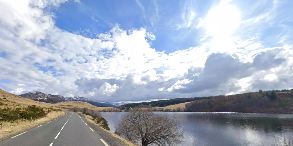
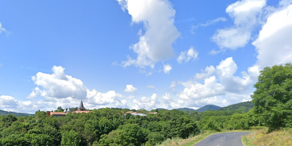
We start our engines and, from Camping Les Dômes, take the D216 to the beautiful village of Orcival, where you can visit the Basilica Notre-Dame d'Orcival, dedicated to Our Lady. We continue south on the winding D27, which becomes the D983 near the Col de Guéry. It's definitely worth stopping here to enjoy the view of the Col, the eponymous lake, Lac de Guéry, and the viewpoint at the twin rocks of the Tuilière and Sanadoire.
We continue our journey via Le Mont-Dore, a well-known thermal spa and a popular ski resort. It lies at an altitude of 1,050 meters, under the watchful eye of the Puy de Sancy, the highest peak of the Monts-Dore and the Massif Central, at 1,885 meters. This is also the birthplace of the Dordogne River, which originates from two small streams, the Dore and the Dogne, which converge here, gathering increasing amounts of water as they flow, to form one of France's most famous rivers. You can choose to stop here for a coffee.
On the next road, the "Col de la Croix Saint-Robert" to "Vallée-de-Chaudefour," it's once again possible to let sparks fly from the footrests. This pass lies in the Monts-Dore mountain range, between the Puy de l'Angle and the Roc de Cuzeau, and is full of delightful bends. This valley, with its sharp granite rocks, was sculpted by glaciers and streams. Now, silence reigns here, and solitary birds of prey circle high above. A rock is named after these birds, "Le Rocher de L'Aigle" (Eagle's Rock). From here, you have a beautiful view of the valley and the Monts-Dore mountain range.
In Vallée-de-Chaudefour, you can choose to stop and hike in this beautiful park, classified as a "National Nature Reserve" since 1991. The stunning landscapes and remarkable biodiversity are unparalleled: streams, waterfalls, grassy meadows, glacial valleys, and magnificent formations such as the Crête du Coq (Rooster's Comb) and the Dent de la Rancune (Tooth of Rancune). If you enjoy holidays surrounded by nature, this unique nature park in Auvergne will undoubtedly exceed your wildest expectations. An additional overnight stay nearby is a good option to consider.
The next town we visit is Besse-en-Chandesse, a charming little town with several black houses built from lava. The best example is Rue de Ia Boucherie. It's definitely worth stopping here to stretch your legs and have a drink or a bite to eat in one of the many cafés and restaurants.
After a short stop, we continue to the town of Murol, nestled among forests and streams, near the beautiful Lake Chambon. Just outside the town lies the enormous castle, "Château de Murol," which seems out of proportion compared to the village. The 13th-century structure resembles an impregnable block of volcanic rock, and that was precisely its intention. Its current purpose is more peaceful, featuring musical spectacles and simulated medieval battles.
After this, the route climbs again via the D213 to the Col de La Ventouse. This pass is located in the Massif Central, in the municipality of Aydat, at an altitude of 964 m and marks the maximum elevation of the D213. Here, we turn onto the D2089 to continue, via the towns of Fontfreyde, St. Genès, and Manson (the original route goes via Laschamp) to the Puy de Dômes (RP20) to enjoy the view and the sunset. We return to the campsite via the "Col de Ia Moreno."
 Links
Links  Usage
Usage Want to download this route?
You can download the route for free without MyRoute-app account. To do so, open the route and click 'save as'. Want to edit this route?
No problem, start by opening the route. Follow the tutorial and create your personal MyRoute-app account. After registration, your trial starts automatically.  Disclaimer
Use of this GPS route is at your own expense and risk. The route has been carefully composed and checked by a MyRoute-app accredited RouteXpert for use on TomTom, Garmin and MyRoute-app Navigation.
Changes may nevertheless have occurred due to changed circumstances, road diversions or seasonal closures. We therefore recommend checking each route before use.
Preferably use the route track in your navigation system. More information about the use of MyRoute-app can be found on the website under 'Community' or 'Academy'.

Auvergne Rhone Alpes
About this region
Auvergne-Rhône-Alpes (ARA; French: [ovɛʁɲ ʁon‿alp] (listen); Arpitan: Ôvèrgne-Rôno-Ârpes; Occitan: Auvèrnhe Ròse Aups; Italian: Alvernia-Rodano-Alpi) is a region in southeast-central France created by the 2014 territorial reform of French regions; it resulted from the merger of Auvergne and Rhône-Alpes. The new region came into effect on 1 January 2016, after the regional elections in December 2015.The region covers an area of 69,711 km2 (26,916 sq mi), making it the third largest in metropolitan France; it had a population of 7,948,287 in 2017, second to Île-de-France. It consists of twelve departments and one territorial collectivity (Lyon Metropolis) with Lyon as the prefecture.
This new region combines diverse geographical, sociological, economic and cultural regions, which was already true of Rhône-Alpes, as well as Auvergne, to a lesser extent. While the old Rhône-Alpes and Auvergne regions each enjoyed a unity defined by axes of communication and the pull of their respective metropoles, the new combination is heterogeneous; it sustained lively opposition from some local officials after its creation.
Read more on Wikipedia
This new region combines diverse geographical, sociological, economic and cultural regions, which was already true of Rhône-Alpes, as well as Auvergne, to a lesser extent. While the old Rhône-Alpes and Auvergne regions each enjoyed a unity defined by axes of communication and the pull of their respective metropoles, the new combination is heterogeneous; it sustained lively opposition from some local officials after its creation.
View region
 Statistics
  129
129Amount of RX reviews (Auvergne Rhone Alpes)
 57261
57261Amount of visitors (Auvergne Rhone Alpes)
 7141
7141Amount of downloads (Auvergne Rhone Alpes)
 Route Collections in this region
 The 24 Most Beautiful Alpine Routes
The Alps, The Alps are a mountain range in Europe, stretching from the French Mediterranean coast in the southwest to the Pannonian Plain in the east. The area of the mountain range is more than 200,000 km².
In other words Passes and Mountain Roads!
Driving through the mountains is great! Especially over the mountain passes with hairpin bends and narrow winding roads. Every bend a different view where you can enjoy. There are many beautiful mountain passes in the Alps.
A selection that has also been incorporated into these routes:
The Stlevio Pass:
The Stelvio Pass, also known as Passo dello Stelvio, is mainly known for the stage in the Giro d'Italia. Due to the length and the difference in height, this pass is seen as one of the toughest tests in cycling. The Stelvio Pass reaches a maximum height of 2758 meters and is therefore one of the highest in the Alps. The pass connects the towns of Bormio and Prato Allo Stelvio. In winter the pass is closed due to heavy snowfall.
The Reschenpass:
The Reschenpass, also known as Passo di Resia, connects the Austrian state of Tyrol with the Italian province of South Tyrol. The pass reaches a maximum height of 1,504 meters and has been one of the most important north-south connections in the Alps in recent centuries. The pass was used long before Roman times. Along the way you will pass several highlights and historical relics. One of the highlights is the Reschensee. This lake was created after the construction of the dam and has completely submerged the village of Graun. The only thing that reminds of that is the clock tower in the middle of the lake.
Col du Galibier:
The French mountain pass Col du Galibier connects the towns of Saint-Michel-de-Maurienne and Briançon via the Col du Lautaret in the south and the Col du Télégraphe in the north. The mountain pass is part of the Tour de France and very much feared, due to the fact that it can only be reached via the other two mountain passes. The pass reaches a maximum height of 2646 meters. From there you can take a walk to the viewpoint at 2704 meters. You can admire the peaks of the Grand Galibier, Mont Blanc and La Meije here.
The Grossglockner High Alpine Road:
With a height of 3798 meters the Grossglockner is the highest mountain in Austria. To fully enjoy this impressive mountain, you can drive over the Grossglockner High Alpine Road and the accompanying pass. The route starts from Bruck am Grossglockner and ends in Heiligenblut. Of course you can drive in two directions. The pass reaches a maximum height of 2504 meters and is closed in winter due to heavy snowfall. Along the way you pass several stops with fun activities, information points, mountain huts and viewpoints. A visit to the Kaiser-Franz-Josefs-Höhe and Pasterzen Glacier is highly recommended.
The Col d'Izoard:
Just like the Col du Galibier, the Col d'Izoard is also part of a stage of the Tour de France. The mountain pass connects Briançon with the valley of the river Guil. The pass is partly located in the Regional Natural Park du Queyras and reaches a maximum height of 2360 meters. What is special about the Col d'Izoard is the barren and rocky landscape. Sometimes it feels like driving a car over the moon! Along the way you can stop at several points to enjoy the beautiful view.
The Bernina Pass:
The Bernina Express is one of the most famous rail trains in Switzerland and the Alps. The route is beautiful and partly included on the UNESCO World Heritage List. Parallel to the railway lies the Bernina pass, which connects the Veltlin valley with the Egandin valley. This beautiful Alpine road has a total length of 56 kilometers and reaches a maximum height of 2328 meters. Along the way you can enjoy views of the Morteratsch Glacier.
The Sella Pass:
The Sella Pass, also known as Passo di Sella, takes you over one of the most impressive mountain ranges in the Dolomites: the Sella massif. The pass connects Valle di Fassa with Val Gardena and reaches a maximum height of 2236 meters. At this height is also the border of the Italian provinces of Trentino and Bolzano. Along the way you can enjoy the view of this spectacular mountain world. Admire, for example, the three peaks of the Sasso Lungo massif, the Sella massif or the peaks of the Marmolada. You can also drive the Sella pass in combination with the Gardena pass, Pordoi pass and Campolongo pass.
The Grimsel Pass:
The Grimsel Pass connects Goms in Wallis with the Halis Valley in the Bernese Oberland. The pass reaches a maximum elevation of 2165 meters and is closed in winter due to snowfall. Over the centuries, the mountain pass has played an important role in trade between Switzerland and Italy. Now it is mainly the reservoirs that have an important function. These are used to generate electricity. The landscape you drive through is rugged, rocky and impressive. On top of the pass is a hotel and a restaurant with a special marmot park. The Dodensee (Totensee) is also located here. This lake owes its name to the many soldiers who died in the time of Napoleon.
The Gotthard Pass:
The Gotthard Pass, also known as Passo del San Gottardo and Saint Gotthard, connects the Swiss towns of Airolo and Andermatt. The mountain pass and associated tunnel are especially known among holidaymakers driving from Switzerland to Italy. But where the majority opt for the tunnel, it is precisely the pass that really completes the holiday. The Gotthard Pass has a length of about 26 kilometers and reaches a maximum height of 2106 meters. The route is beautiful and takes you along old villages and beautiful views.
The Silvretta High Alpine Road and Silvretta Pass:
The Paznaun Valley in Tyrol and the Montafon in Vorarlberg are connected by the Silvretta High Alpine Road. The route has a length of 22.3 kilometers and leads from Galtür to Partenen in 34 hairpin bends, via the 2032 meter high Bielerhöhe. The Silvrettasee is also located at this point, where you can enjoy a lovely walk. The pass is closed in winter due to snowfall.
The Simplon Pass:
Just like the Gotthard Pass, many holidaymakers also travel over the Simplon Pass every year. This mountain pass connects the Rhone Valley in the canton of Valais with the Valle d'Ossola in Piemonte. The pass is open all year round and reaches a maximum height of 2005 meters. Along the way you pass a number of buildings, including the well-known Simplon Hospiz from 1825. The hospiz is managed by the monks of St. Bernard. From the highest point on the pass, all kinds of hiking routes are possible and you will also come across a hotel where you can spend the night.
The Gerlos Pass:
The Gerlos Pass connects the Salzach Valley in the Salzburgerland with the Zillertal Valley in Tyrol. The pass is part of the Gerlos Alpenstraße and runs right through the Hohe Tauern National Park. Along the way you can enjoy beautiful views of the surroundings. The pass has a length of 12 kilometers and reaches a maximum height of 1531 meters. A ride over the Gerlos Pass can be ideally combined with a visit to the Krimmler Wasserfälle.
The Great St. Bernard Pass:
The Great St. Bernard Pass, better known as Col du Grand Saint Bernard, connects the Italian province of Valle d'Aosta with the Swiss canton of Valais. The pass is one of the highest in Switzerland and reaches a maximum height of 2469 meters. Like a number of other mountain passes in this list, the Great St. Bernard Pass has also been used as a connecting road for centuries. The pass is named after the St. Bernard dogs that used to help stranded travelers along with the monks. The pass is closed in winter.
The Timmelsjoch High Alpine Road:
The Timmelsjoch High Alpine Road connects the towns of Sölden in the Ötztal and Meran in South Tyrol. Tolls must be paid on the Hochgurgl - Moos route. Via a mountain road with about 60 hairpin bends you drive through a beautiful mountain world. With the Timmelsjoch Experience you can learn more about the history, the road and the environment via various stations. You can also visit the Top Mountain Crosspoint museum.
Col de l'Iseran:
With a maximum pass height of 2770 meters, the Col l'Iséran is one of the highest mountain passes in the Alps. The pass connects Bourg-Saint-Maurice with Bonneval-sur-Arc. Via a road full of hairpin bends you pass, among other things, Val-d'Isère and a side valley of the Maurienne that lies entirely in the National Park de la Vanoise. You can spot animals such as marmots and chamois and there is also a restaurant with a chapel on top of the pass.
The Gavia Pass:
The Gavia Pass (Italian Passo di Gavia) is a mountain pass in the Italian Alps, in the Lombardy region.
It is one of the highest pass roads in Europe. The road leads through the unspoilt Stelvio National Park. The road was built in the First World War to supply Italian soldiers who fought in the Italian-Austrian border area. The pass height is one of the most beautiful in the Alps. Here is the large Lago Bianco with, to the north, the mountain San Matteo (3684 meters). Lago Nero is slightly lower on the south side of the pass. Here the mountain group of the Adamello determines the view. There are many well-marked walks in the area. During the winter the pass is closed due to the heavy snowfall. The pass is often closed until May and June due to the large amount of snow.
Promoter has made a selection of the 24 Most Beautiful Alpine routes that they have set out in recent years.
The routes go through:
France
Austria
Switzerland
Italy
The most beautiful roads, the most beautiful views, the most beautiful viewpoints. The highest mountains, the fastest descents, hairpin bend after hairpin bend, you name it you can't get enough of it.
If you go on holiday in this region, take advantage of it, ALL routes in this collection have been checked and made equal for TomTom, Garmin and MyRoute-app Navigation by a MyRoute-app RouteXpert.
Have fun with this collection and while driving one of these routes. Enjoy all the beauty that the Alps and the Dolomites have to offer. Click on “View route” to read the review of the chosen route.
I would like to hear your findings about the route(s).
View Route Collection
25 Magnificent trails in France
This MRA route collection contains 25 beautiful motorcycle routes in different parts of France, such as the Ardennes, the Alsace, Vercors, the Drôme, the Ardèche, Cote d'Azure, Gorges du Verdon, the Ariège, the Dordogne and Brittany.
The routes have been carefully created by Bert Loorbach, who is an enthusiastic motorcyclist himself. He lived in France for a year and a half, during which time he devoted himself to mapping the unknown and beautiful back roads of France especially for motorcyclists.
The routes are bundled in the Motortourgids France part 1 of Kosmos publishing house and now also available in MyRouteApp.
I have taken over the routes in MRA and sometimes adjusted them slightly to make them even more interesting for the motorcyclist.
View Route Collection