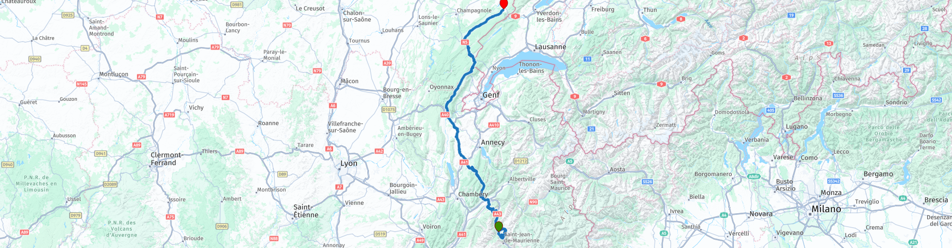
R05 - St Etienne de Cuines to Metabief

Questo percorso è stato creato da:
RouteXpert Arno van Lochem - Senior RX
Ultima modifica: 29-12-2020
 Riepilogo percorso
 Il percorso termina a Metabief, un piccolo paese di campagna nell'est della Francia.
Il percorso è per i motociclisti più esperti visti gli occasionali tornanti stretti. Si desidera una buona gestione del motore!
 Condividi questo percorso


Animation

Verdetto


Durata
6h 11m

Modalità di viaggio
Auto o moto

Distanza
294.72 km

Paesi

 Revisione RouteXpert
 Data la diversità del percorso e gli splendidi dintorni che attraversi, valuto questo percorso con 5 stelle.
Il percorso parte dal B&B Hotels Saint-Étienne-de-Cuines, situato nell'omonima località. Si parte subito bene, dopo un chilometro o due il Col du Chaussy è in programma. Non è di per sé un colle molto alto (1533 metri), ma l'inizio è sicuramente notevole: 17 tornanti in meno di due chilometri. O in realtà dovrei dire "tornanti", è tutto molto stretto. La città ai piedi di questa salita può essere vista ridursi rapidamente con molti colpi di scena.
Una volta in cima, ti verranno presentate splendide viste. Nella parte più alta di questo passo si percorrono ripide scogliere che a volte sono persino sospese sulla strada. Bello da vedere! In discesa si incontrano alcuni tornanti prima di finire sulla D1006.
A Épierre si lascia questa D1006 e si svolta a sinistra per seguire la D207. Questa strada attraversa il Col du Grand Cucheron con un'altezza del passo di 1183 metri. Il passo si trova nella parte settentrionale dei Monti Belledonne e collega la valle della Maurienne con la valle dell'Isère.
Questo passo è presto seguito dal Col de Champlaurent, un passo alto 1097 metri. Bellissimo valico di cui la discesa percorre in gran parte il bosco. Poche viste come risultato, ma in una giornata di sole in estate è molto fresco. Ne vale la pena.
A Saint-Pierre d'Albigny hai la possibilità di rivolgerti a Chateau de Miolans. Il castello di Miolans si trova a 550 metri sul livello del mare ed è classificato monumento storico dal 1944.
La Fortezza di Miolans (francese: Château de Miolans) è un'ex prigione fortezza in una remota area della Savoia in Francia. Occupata sin dal IV secolo d.C., la fortezza gestiva strategicamente il percorso attraverso l'intersezione dei fiumi Isère e Arc (che si è appena passati al RP9 e RP10). La fortezza fu trasformata in prigione dai Conti di Savoia a metà del XVI secolo. Per la sua fama è stato paragonato alla Bastiglia di Parigi.
Il percorso prosegue sulla D911 e poco dopo si incontra il Col du Frêne, a 950 metri di altezza. Solo la salita presenta più tornanti, la discesa è più graduale. È evidente che le Alpi sono alle tue spalle, le montagne si stanno abbassando. D'altra parte, guidi nel Giura, un'area di una bellezza senza precedenti che sicuramente vale la pena.
Per molti chilometri avete seguito la D911, a Pont de Bauges si deve percorrere un breve tratto sulla D5. Dopo circa tre chilometri, svoltare a sinistra sulla D31. Questa strada attraversa il Pont de l'Abime.
Il Pont de l'Abime è un ponte sospeso con una campata di quasi 75 metri. L'altezza (altezza libera) di questo ponte è di 96 metri. Inoltre, il ponte evita una deviazione di quasi 8 chilometri a monte del fiume. Il traffico automobilistico può essere fatto solo in modo alternato a causa della larghezza limitata che non consente il passaggio di veicoli di grandi dimensioni.
Il percorso si snoda più a nord attraverso il Giura. Intorno a te si alternano colline, piccoli borghi e vaste foreste. Non sono strade sterzanti spettacolari (soprattutto se si tiene fede alla velocità ...), ma la varietà del paesaggio rende molto piacevole guidarci. Non dimenticare di fermarti ogni tanto per una foto!
Nel punto in cui la D936 incontra la D1005, c'è la possibilità di fare una breve deviazione dal percorso al Col de la Faucille. Su questo colle si trova anche lo Luge d'Été, dove tra l'altro è stata costruita una pista per slittini. Dal parcheggio puoi già vedere come gira la pista e puoi vedere i piccoli carri che "scivolano" lungo i binari.
Se vuoi una bella vista sul Lago di Ginevra e sulla città che dà il nome al lago, percorri due chilometri più avanti sulla D1005 fino al parcheggio al primo tornante. Sarà ricompensato con una vista fantastica!
Di nuovo sulla D1005, segui questa strada che diventa N5 a Les Rousses. A Hauts de Bienne fai un breve viaggio attraverso il villaggio per visitare possibilmente il Musee de la lunette. Questo museo di occhiali ospita una delle collezioni di montature più prestigiose al mondo. Il museo ti aiuterà anche a capire il funzionamento dell'occhio, l'organo della vista. Con mostre divertenti, imparerai a conoscere le principali condizioni degli occhi e non lasciarti ingannare dalle loro illusioni ottiche.
Il percorso prosegue sulla N5. A Saint-Laurant-en-Grandvaux viene scambiato con la D437. I meandri del paesaggio francese verso nord-est. Non è certo un pezzo noioso, perché c'è ancora molta varietà negli splendidi dintorni. A Gellin prendi l'uscita per la D45. A Saint-Antoine il percorso percorre l'ultimo tratto della D9 che porta a Mètabief, meta finale di questo percorso.
L'Hotel Etoile de Neige, dove finisce il percorso, è un piccolo ma accogliente albergo dove è bene soggiornare. Piscina e sauna sono disponibili, quindi rilassati! Le "birre speciali" come la Leffe Blond erano le migliori!
Divertiti a guidare questo percorso!


 Collegamenti
  Utilizzo
 Vuoi scaricare questo percorso?
Puoi scaricare il percorso gratuitamente senza un account MyRoute-app. Per farlo, apri il percorso e fai clic su 'Salva con nome'. Vuoi modificare questa rotta?
Nessun problema, inizia aprendo il percorso. Segui il tutorial e crea il tuo account MyRoute-app personale. Dopo la registrazione, la tua prova inizia automaticamente.  Disclaimer
L'utilizzo di questo percorso GPS è a tue spese e rischio. Il percorso è stato accuratamente composto e controllato da un RouteXpert accreditato dall'app MyRoute per l'utilizzo su TomTom, Garmin e navigazione dell'app MyRoute.
Ciononostante potrebbero essersi verificati cambiamenti a causa di mutate circostanze, deviazioni stradali o chiusure stagionali. Si consiglia pertanto di controllare ciascun percorso prima dell'uso.
Utilizzare preferibilmente la tracklog del percorso nel sistema di navigazione. Maggiori informazioni sul l'uso dell'app MyRoute può essere trovato sul sito Web in 'Community' o 'Academy'.