R03 Round trip Ribeauville

This route was brought to you by:
RouteXpert Hans van de Ven (Mr.MRA)
Last edit: 18-04-2021
 Route Summary
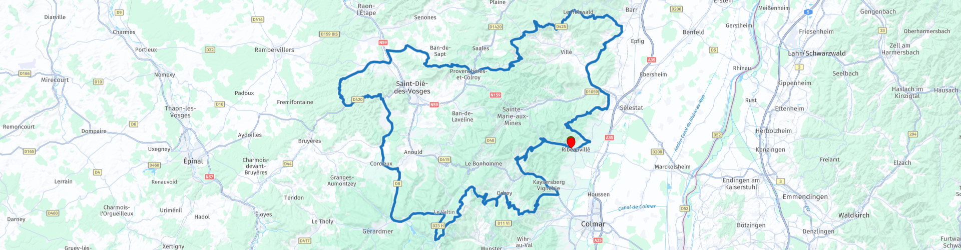
 Start and end point: Ribeauville, Au Cheval Blanc
The route is equalized for Garmin, TomTom and MRA Navigation.
Bon voyage.
 Share this route


Animation

Verdict


Duration
7h 9m

Mode of travel
Car or motorcycle

Distance
255.09 km

Countries

 RouteXpert Review
 Ribeauvillé is a tourist attraction. Many alleys, squares and shops. Colored houses, winegrowers, cafes and restaurants. So one more night in this beautiful town, but first a nice tour. Soon after your departure from Ribeauvillé you will cross the 1st of 8 cols that are included in the route today, namely Col de Fréland. The route winds through the beautiful French landscape and you also pass through some towns such as Ammerschwihr, this wine town has 1,892 inhabitants and is part of the arrondissement of Colmar-Ribeauvillé. Great opportunity to take a picture of these French-German towns. After driving about 75 kilometers, it is time to stretch your legs and provide the inner man with a treat. You are then on the Col de la Schlucht, this mountain pass owes its name to the German word Schlucht, which means mountain gorge.
After coffee it goes towards the Col du Haut Jacques, where you can stop for a moment with the monument of the US 3rd Infantry Division. This memorial commemorates that the US 3rd Infantry Division liberated the Col du Haut Jacques between October 20 and November 10, 1944, at the cost of 148 dead and 822 wounded. After driving another 70 kilometers, it's time to stop again, you can do this at the snack bar in Saint-Michel-sur-Meurthe. After the stop, meander further and successively cross the Col d'Urbeis, Col de la Charbonnière & Col du Kreuzweg, after a short 2 hours drive, you arrive in Le Hochwald, where Auberge a l'Ancienne Grange is located. Nice restaurant to eat and / or drink something.
After this last stop it is still a small 50 KM to meander to Ribeauvillé, but first Col du Schaentzel, once in Ribeauvillé, refuel and go to the hotel, where you can still enjoy the day while enjoying the French delicacies. .
Because I have ridden most of this wonderful to drive route, I rate this route with 4 stars. Enjoy the beautiful views.


 Links
Links  Usage
Usage Want to download this route?
You can download the route for free without MyRoute-app account. To do so, open the route and click 'save as'. Want to edit this route?
No problem, start by opening the route. Follow the tutorial and create your personal MyRoute-app account. After registration, your trial starts automatically.  Disclaimer
Use of this GPS route is at your own expense and risk. The route has been carefully composed and checked by a MyRoute-app accredited RouteXpert for use on TomTom, Garmin and MyRoute-app Navigation.
Changes may nevertheless have occurred due to changed circumstances, road diversions or seasonal closures. We therefore recommend checking each route before use.
Preferably use the route track in your navigation system. More information about the use of MyRoute-app can be found on the website under 'Community' or 'Academy'.

Grand Est
About this region
Grand Est (French: [ɡʁɑ̃t‿ɛst] (listen); Alsatian: Grossa Oschta; Moselle Franconian/Luxembourgish: Grouss Osten;
Rhine Franconian: Groß Oschte; German: Großer Osten [ˈɡʁoːsɐ ˈʔɔstn̩]; English: "Greater East") is an administrative region in Northeastern France. It superseded three former administrative regions, Alsace, Champagne-Ardenne and Lorraine, on 1 January 2016 under the provisional name of Alsace-Champagne-Ardenne-Lorraine (pronounced [alzas ʃɑ̃paɲ aʁdɛn lɔʁɛn]; ACAL or, less commonly, ALCA), as a result of territorial reform which had been passed by the French Parliament in 2014.The region sits astride three water basins (Seine, Meuse and Rhine), spanning an area of 57,433 km2 (22,175 sq mi), the fifth largest in France; it includes two mountain ranges (Vosges and Ardennes). It shares borders with Belgium, Luxembourg, Germany and Switzerland. As of 2017, it had a population of 5,549,586 inhabitants. The prefecture and largest city, by far, is Strasbourg.
The East of France has a rich and diverse culture, being situated at a crossroads between the Latin and Germanic worlds. This history is reflected in the variety of languages spoken there (Alsatian, Champenois, and Lorraine Franconian). Most of today's Grand Est region was considered "Eastern" as early as the 8th century, when it constituted the southern part of the Francian territory of Austrasia. The city of Reims (in Champagne), where Frankish king Clovis I had been baptized in 496 AD, would later play a prominent ceremonial role in French monarchical history as the traditional site of the coronation of the kings of France. The Champagne fairs played a significant role in the economy of medieval Europe as well. Alsace and Lorraine thrived in the sphere of influence of the Holy Roman Empire for most of the Middle Ages and Renaissance, and subject to competing claims by France and German over the centuries.
The region has distinctive traditions such as the celebration of Saint Nicholas Day, Christmas markets, or traditions involving the Easter hare in Alsace and Lorraine. Alsace-Moselle are furthermore subject to local law for historical reasons. With a long industrial history and strong agriculture and tourism (arts, gastronomy, sightseeing), the East of France is one of the top economic producing regions in the country.
Read more on Wikipedia
Rhine Franconian: Groß Oschte; German: Großer Osten [ˈɡʁoːsɐ ˈʔɔstn̩]; English: "Greater East") is an administrative region in Northeastern France. It superseded three former administrative regions, Alsace, Champagne-Ardenne and Lorraine, on 1 January 2016 under the provisional name of Alsace-Champagne-Ardenne-Lorraine (pronounced [alzas ʃɑ̃paɲ aʁdɛn lɔʁɛn]; ACAL or, less commonly, ALCA), as a result of territorial reform which had been passed by the French Parliament in 2014.The region sits astride three water basins (Seine, Meuse and Rhine), spanning an area of 57,433 km2 (22,175 sq mi), the fifth largest in France; it includes two mountain ranges (Vosges and Ardennes). It shares borders with Belgium, Luxembourg, Germany and Switzerland. As of 2017, it had a population of 5,549,586 inhabitants. The prefecture and largest city, by far, is Strasbourg.
The East of France has a rich and diverse culture, being situated at a crossroads between the Latin and Germanic worlds. This history is reflected in the variety of languages spoken there (Alsatian, Champenois, and Lorraine Franconian). Most of today's Grand Est region was considered "Eastern" as early as the 8th century, when it constituted the southern part of the Francian territory of Austrasia. The city of Reims (in Champagne), where Frankish king Clovis I had been baptized in 496 AD, would later play a prominent ceremonial role in French monarchical history as the traditional site of the coronation of the kings of France. The Champagne fairs played a significant role in the economy of medieval Europe as well. Alsace and Lorraine thrived in the sphere of influence of the Holy Roman Empire for most of the Middle Ages and Renaissance, and subject to competing claims by France and German over the centuries.
The region has distinctive traditions such as the celebration of Saint Nicholas Day, Christmas markets, or traditions involving the Easter hare in Alsace and Lorraine. Alsace-Moselle are furthermore subject to local law for historical reasons. With a long industrial history and strong agriculture and tourism (arts, gastronomy, sightseeing), the East of France is one of the top economic producing regions in the country.
View region
 Statistics
  84
84Amount of RX reviews (Grand Est)
 42698
42698Amount of visitors (Grand Est)
 14338
14338Amount of downloads (Grand Est)
 Route Collections in this region
 25 Magnificent trails in France
This MRA route collection contains 25 beautiful motorcycle routes in different parts of France, such as the Ardennes, the Alsace, Vercors, the Drôme, the Ardèche, Cote d'Azure, Gorges du Verdon, the Ariège, the Dordogne and Brittany.
The routes have been carefully created by Bert Loorbach, who is an enthusiastic motorcyclist himself. He lived in France for a year and a half, during which time he devoted himself to mapping the unknown and beautiful back roads of France especially for motorcyclists.
The routes are bundled in the Motortourgids France part 1 of Kosmos publishing house and now also available in MyRouteApp.
I have taken over the routes in MRA and sometimes adjusted them slightly to make them even more interesting for the motorcyclist.
View Route Collection
11 day trip from the Netherlands
8 countries in 11 days; The Netherlands, Germany, Austria, Italy, Switzerland, France, Luxembourg and Belgium. This route collections consists of 10 routes that I have driven with friends in the summer of 2019.
The start is in Geldermalsen Netherlands, the first 7 days you drive through the Netherlands, Germany, Austria, Italy, Switzerland, France and a piece of Luxembourg with overnight stays in hotels.
The last three days you stay in Barweiler (D) in the Eifel and you drive two beautiful tours through the Eifel, Luxembourg and parts of the Belgian Ardennes.
There is no highway in the routes, only beautiful provincial and country roads, many beautiful passes with beautiful panoramas.
Be sure to check whether the passes are open before you leave.
These are routes for experienced drivers.
View Route Collection