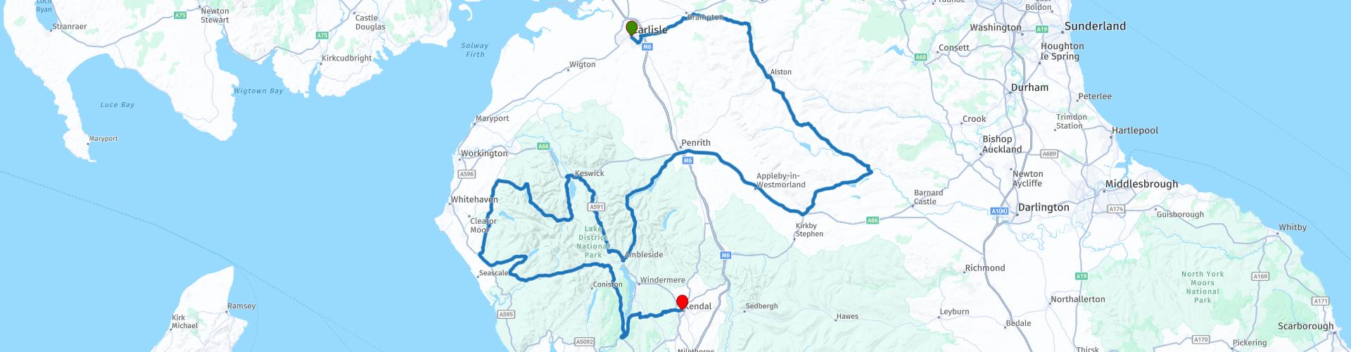
Carlisle to Kendal

This route was brought to you by:
RouteXpert Peter Moerman - RouteXpert
Last edit: 08-04-2021
 Route Summary
 We drove the route ourselves in 2017 as part of a 4-day tour through Northern England and the National Parks within it. This is the 2nd route.
The route is good for everyone to ride in a long day with time to stop and enjoy the beautiful views. However, there are 2 somewhat more difficult passages with steep slopes that require some driving experience.
You must leave on time in the morning in order not to arrive late in the evening. For those who find the route too long, it can easily be shortened by taking the A686 towards Penrith at Alston and resuming the route there. The route will then be approximately 285 km and 9.15 hours. The long route is over 11 hours, but this includes all long and short stops. In practice it takes less time.
The continuation of this route runs from Kendal to York
 Share this route


Animation

Verdict


Duration
11h 36m

Mode of travel
Car or motorcycle

Distance
345.70 km

Countries

 RouteXpert Review
 You can choose the long route of 345 km or the shorter route of 285 km, with the latter you will skip part of the North Pennines.
From Carlisle it is only 15 miles to the North Pennines. North Pennines is the most northerly part of the Pennine Mountains, a four hundred kilometer ridge in central northern England. It contains wetlands and there are highland valleys. North Pennines lies between Carlisle to the east and Darlington to the west. Tyne Valley is the northern limit and Stainmore Gap the southern. The area includes parts of the counties of Cumbria, Durham and Northumberland. In 1988, North Pennines was designated an Area of Outstanding Natural Beauty because of its moorland landscapes (moors) and traces of centuries of agricultural use and lead mining. At nearly 2000 square kilometers, it is the second largest of 40 AONBs in the United Kingdom and Wales. After the descent from the North Pennines we make the short crossing to the Lake District.
The Lake District National Park is a national park in the county of Cumbria in northwest England. It is one of fifteen national parks in the United Kingdom. The park was established in 1951 and covers 2,362 square kilometers. The Lake District is a mountainous region. In this area are all the peaks of England that are higher than 900 meters above sea level. The highest, at 978 meters, is Scafell Pike. The area has been on the Unesco World Heritage List since July 2017. The Lake District has sixteen lakes, mostly elongated in shape, which can be explained by the fact that in the Pleistocene Ice Age the river valleys were transformed by glaciers into wide trough valleys. The most famous lakes are Windermere (14.7 km²), Coniston Water, Ullswater, Thirlmere, Derwent Water and Bassenthwaite Lake. Buttermere, Crummock Water and Loweswater also testify to the natural beauty of the Lake District. Well-known hills are Coniston Old Man, Scafell, Scafell Pike, Skiddaw, Great Gable, and Helvellyn. The hills are rugged and suitable for long walks with lots of natural beauty, including difficult routes that are more suitable for mountaineers. However, if the weather changes while unprepared, it is quite easy to end up in dangerous conditions.
The route winds along some of these lakes and covers a large part of the Lake District. There are parking places at various places and you can enjoy the beautiful surroundings. In the extreme southwest you have a beautiful view of the sea and the enormous complex of the Sellafield nuclear power plant.
Sellafield is a nuclear complex near the town of Seascale on the Irish Sea in northwest England. The complex includes a nuclear waste reprocessing plant and several decommissioned nuclear reactors.As part of the British nuclear weapons program, a nuclear reactor was built near the town of Windscale in 1952 for the production of plutonium for nuclear weapons, followed by a nuclear power plant for the production of electricity. , Calder Hall. Despite a long series of accidents and many protests, the British government decided in 1978 to build a nuclear waste reprocessing plant next to the plant. The reprocessing plant was put into operation in 1994. In March 2003 the Calder Hall power station was closed.
After the coast the route goes inland again through forests and along lakes. The most spectacular part of the route then follows quickly, namely the Hardknott Pass and the Wrynose Pass. This mountain pass is known as the steepest road in England with a gradient of 33% on some parts. The pass is named after Hard Knott, a hill of 549 m, near the highest point of the mountain pass. The road was built by the Romans around 110 AD. laid out under Hadrian's rule. They are not very high, but with a gradient of more than 30% and the sharp hairpin bends a challenge for many. The views are fantastic so don't forget to stop and look back from time to time in a safe place.
The last part of the route goes towards civilization and in Kendal there are several overnight accommodations and dining options. See the POIs for the route. We ourselves spent the night at the Stonecross Manor Hotel in a nice spacious room, but it is located outside the center.
A special tip is restaurant The Black Labrador, about 6 kilometers before Kendal, where we had a delicious meal ourselves. Not really a biker's restaurant but well worth it and well frequented by the locals.
I give this route 4.5 stars because of the attractive surroundings, beautiful sights, the challenging passes and the excellent roads.


 Links
Links  Usage
Usage Want to download this route?
You can download the route for free without MyRoute-app account. To do so, open the route and click 'save as'. Want to edit this route?
No problem, start by opening the route. Follow the tutorial and create your personal MyRoute-app account. After registration, your trial starts automatically.  Disclaimer
Use of this GPS route is at your own expense and risk. The route has been carefully composed and checked by a MyRoute-app accredited RouteXpert for use on TomTom, Garmin and MyRoute-app Navigation.
Changes may nevertheless have occurred due to changed circumstances, road diversions or seasonal closures. We therefore recommend checking each route before use.
Preferably use the route track in your navigation system. More information about the use of MyRoute-app can be found on the website under 'Community' or 'Academy'.