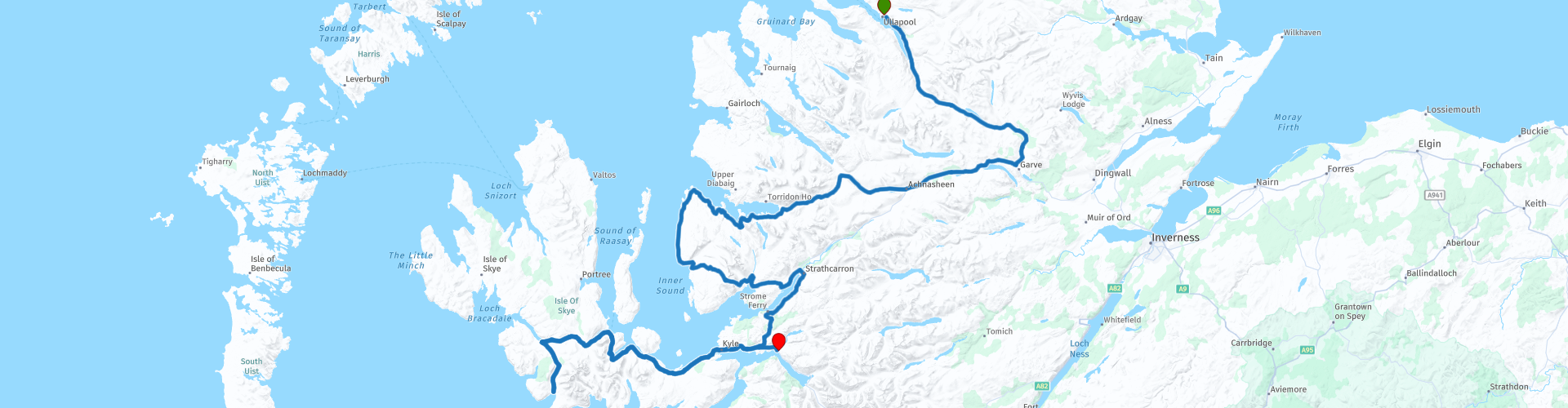
06 Ullapool to Dornie via Applecross and Isle of Skye

This route was brought to you by:
RouteXpert Nick Carthew - (MRA Master)
Last edit: 26-02-2026
 Route Summary
 Unsurpassed coastal scenery, interspersed with mountains and lochs. Some roads are single track but all have been surfaced, some better than others! Applecross Pass can be difficult in bad weather.
The landscape with it's breathtakingly beautiful views is why I have awarded the maximum 5⭐⭐⭐⭐⭐ stars for this route.
 Share this route


Animation

Verdict


Duration
8h 56m

Mode of travel
Car or motorcycle

Distance
353.39 km

Countries

 RouteXpert Review
 The landscape along this route is breathtakingly beautiful and not far from the start at Ullapool you can park in the layby on the left, cross the road and go down the bank into the Corrieshalloch Gorge National Nature Reserve. You can walk out on a viewing platform to see the Falls of Measach, a 46 metre waterfall on the Abhainn Droma river at the head of the mile-long Corrieshalloch Gorge.
Then, after passing Loch Glascarnoch you can take a small turn right to visit Black Water Falls. Just 2 hundred metres to this picturesque spot featuring the Black Water Falls and Silverbridge, an old stone bridge over the water which you can walk down to and underneath. Well worth stopping here to stretch your legs and marvel at the stonemasons' workmanship and the beautifull waterfall.
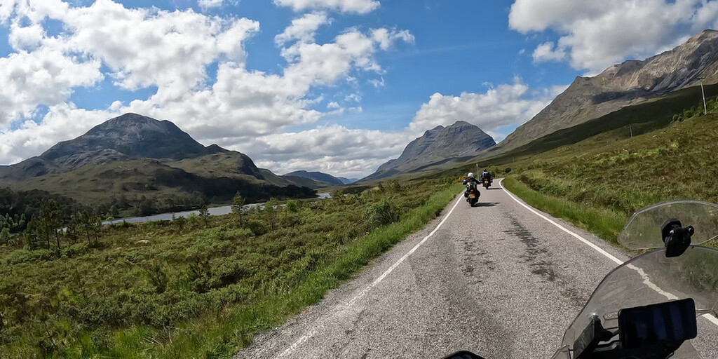
You will now pass a few lochs connected by the River Bran that will take you to the Kinlochewe viewpoint. Looking down Glen Docherty, you'll catch your first sight of stunning Loch Maree, a magnificent fresh water loch dotted with more than 60 islands which contain some of the last fragments of the ancient Caledonian Pine Forest.
You will enter Beinn Eighe National Nature Reserve. With a cluster of mountain peaks, ancient pinewoods, secretive crossbills and soaring golden eagles, it's no wonder that Beinn Eighe was chosen as Britain's first National Nature Reserve. From a distance, the pale scree slopes on the mountain-side look like barren fields of snow, but get up close and you'll be amazed by the diversity of wildlife that thrives on this reserve.
Loch Torridon is a sea loch and your first glimpse of the sea, it is an important prawn and shellfish fishery and is also home to several salmon farms and industrial mussel production.
The beautiful village of Shieldaig would be a finalist in any "most picturesque village in Scotland" competition. Its location is truly superb, on the edge of Loch Shieldaig. It was established in 1800 to attract families to take up fishing for a living and in the process, to help build up a stock of trained seamen who could be called upon by the Royal Navy during the Napoleonic wars. People were attracted to the village by the offer of grants from the Admiralty to support housing and boat-building and Shieldaig flourished.
Now you turn onto the Applecross peninsular, a little caution is required on the single track road as there are animals walking freely. The coastal views are breathtaking with the mountains of the Isle of Skye as a backdrop as you navigate this scenic road to Applecross where I have suggested lunch at the Inside Out catering van (an old American Airstream) parked outside of the Applecross Inn, they serve delicious fish and chips and great coffee.
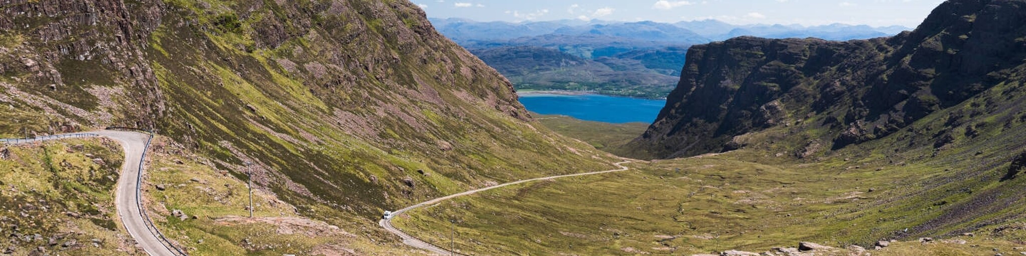
After lunch comes the star of the show, in my eyes the highlight of this route, the iconic Applecross Pass (Bealach na Bà). The road leading to and over Applecross, or the Bealach na Bà is considered as one of best riding routes in the UK. Bealach na Bà, translates from Gaelic as Pass of the Cattle, it was used in earlier days to drive cattle from Applecross and other surrounding settlements. It is single track road that was built in 1822 that twists and turns as it climbs and descends the mountain and is considered to be one of the most challenging rides in Scotland. This area is prone to heavy mist and can be dangerous in low visibility conditions. It has a well-deserved reputation for being dangerous and can be extremely challenging. The best times for riding Bealach na Bà are generally between late April and June and early September to late October.
The views towards the Isle of Skye from the summit on a clear day are awe-inspiring but my favourite view is as you descend on the other side at the layby just by Lenart's Corner. It offers a great place to photograph your bike with the twisting road, mountain gap and Loch Kisshorn as a backdrop.
When you reach the A87 you have a choice to turn right to visit the Isle of Skye or left to check into your hotel.
Crossing over the Skye Bridge and hugging the coast along the shores of sea lochs, you will instantly feel the magic and beauty of Skye. This route visits the road to Glenbrittle, possibly the best scenic road on the Isle of Skye. Throughout the few miles from Carbost to Glen Brittle your attention will increasingly be drawn to the ever more striking mass of the Cuillin Hills ahead of you. This ferocious range of mountains, by far the most challenging for climbing in Scotland, have a jagged greyness that seems completely out of place in its green island setting.
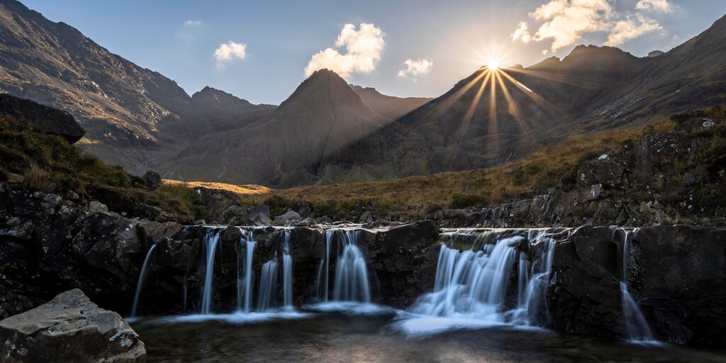
The reason for travelling on the Glen Brittle road is to visit the Fairy Pools.
There is no charge to see the Fairy Pools but there is a charge for parking.
The walk to the pools uses the same route there and back on a purpose-made good gravel path. The complete return distance to the first main waterfall and pool is 2.4km, with the average time to complete the walk being 40 minutes to an hour and a half (with no stops and depending on your level of fitness). Most people will spend some time working their way up the river from the first waterfall exploring the different pools.
A little time and commitment is required but the spectacle of the Fairy Pools is worth it.
I would suggest spending a whole day exploring more of this mystical and mythical land but if time is short, this 4 hour section will give you a good flavour of what the Isle of Skye has to offer.
Enjoy
 Links
Links  Usage
Usage Want to download this route?
You can download the route for free without MyRoute-app account. To do so, open the route and click 'save as'. Want to edit this route?
No problem, start by opening the route. Follow the tutorial and create your personal MyRoute-app account. After registration, your trial starts automatically.  Disclaimer
Use of this GPS route is at your own expense and risk. The route has been carefully composed and checked by a MyRoute-app accredited RouteXpert for use on TomTom, Garmin and MyRoute-app Navigation.
Changes may nevertheless have occurred due to changed circumstances, road diversions or seasonal closures. We therefore recommend checking each route before use.
Preferably use the route track in your navigation system. More information about the use of MyRoute-app can be found on the website under 'Community' or 'Academy'.